Maps of Corse

L ́ Isola di Corsica Divisa nelle sue Provincie

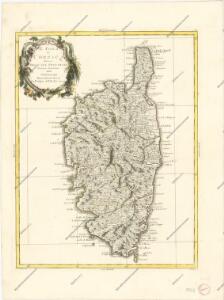
L'ISOLA DI CORSICA
1 : 300000 Korsika (Francie) Robert de Vaugondy, Didier Calcografia della R.C.A.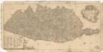
Carta dell isola di Corsica
1 : 700000 Korsika (Francie) Policardi, Domenico Chiesa, Inocenzo Domenico Policardi
Corsica Insula. [Karte], in: Le théâtre du monde, ou, Nouvel atlas contenant les chartes et descriptions de tous les païs de la terre, Bd. 3, S. 55.
1 Karte aus Atlas Blaeu, Willem Janszoon und Blaeu, Joan Blaeu, Willem Janszoon
Corsika
Korsika (Francie) Herzlich, W. Gleditsch

Corsica.
1 : 415000 Covens et Mortier
Insula Corsica olim Regni titulo insignis nunc Genuensis Reipublicae potestati subjecta, juxta recentissimam designationem mappa geographica
1 : 350000 aeri incisa per Matthaeum Seutter Aug. Vind : M. Seutter
Corsica.[Karte] , in: Theatrum orbis terrarum, S. 520.
1 Karte aus Atlas Ortelius, Abraham Vrients, Jan Baptista
Carte de l isle de Corse
1 : 260000 Korsika (Francie) S. Angelo, de Lattré Lattré
Département de la Corse
1 : 250000 Korsika (Francie) Dufour, A. H. Guibert Maison Bouasse
Insula Corsica olim Regni titulo insignis nunc Genuensis Reipublicae potestati subjecta, juxta recentissimam designationem
1 : 350000 Amstelodami : apud J. Cóvens et C. Mortier
CORSICA INSVLA.
[Amsterdam : Joan Blaeu]
Nouvelle carte de l'isle de Corce
France Henri Michelot & Laurent Brémond Gerard van Keulen
A map of the island of Corsica
1 : 1039000
Corsica.
1 : 310000 Robert Laurie & James Whittle
CORSICA | INSVLA
[Amsterdam : Joan Blaeu]
Corsica [Karte], in: Gerardi Mercatoris Atlas, sive, Cosmographicae meditationes de fabrica mundi et fabricati figura, S. 468.
1 Karte aus Atlas Mercator, Gerhard Montanus, Petrus
descriptio Corsicae Insulae. [Karte], in: Gerardi Mercatoris et I. Hondii Newer Atlas, oder, Grosses Weltbuch, Bd. 2, S. 323.
1 Karte aus Atlas Mercator, Gerhard und Hondius, Jodocus Jansson, Jan
Corsica. [Karte], in: Theatrum orbis terrarum, S. 227.
1 Karte aus Atlas Ortelius, Abraham
INSULAE CORSICAE accurata CHOROGRAPHIA TRADITA
1 : 560000 Korsika (Francie) Vogt, J. studio Homannian. Heredum


Dept. De Corsica.
1 : 625000 Levasseur, Victor.
Nouvelle carte de l'isle de Corse : apartenante a la Republique de Genes, presentement divisée & soulevée, sous les ordres du Baron de Neuhoff, elu Roy sous le nom de Theodore Premier
1 : 400000 levé sur les lieux par le capitaine I. Vogt donnée au jour par Renier & Iosue Ottens, geographes a Amsterdam Amsterdam : Renier & Iosue Ottens
Corsica Insula. [Karte], in: Novus Atlas, das ist, Weltbeschreibung, Bd. 3, S. 65.
1 Karte aus Atlas Blaeu, Joan Blaeu, Willem Janszoon
La Corsica
1 : 323000 Korsika (Francie) Paoli, Pasquale