Maps of okres Břeclav

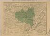
Národnostní mapa Moravy

Národnostní mapa Moravy
1 : 150000 Morava jižní (Česko) Chytil, Alois nákladem Al. Chytila
Der Brünner Kreis
1 : 190000 Brno-oblast (Česko) Schenkl, Conrad Philipp Winiker, Karel von Carl Winiker
Der Brünner Kreis
1 : 192000 Brno-oblast (Česko) Schenkl, Conrad Philipp Winiker, Karel Carl Winiker
Der Brünner Kreis
1 : 192000 Brno-oblast (Česko) Schenkl, Conrad Philipp Winiker, Karel von Carl Winiker
Die Markgraftschaft Mähren
1 : 22000 Brno-oblast (Česko) Schenkl, Conrad Philipp Carl Winiker
[Marchionatus Moraviae circulus Brunnensis]
Brno-oblast jižní (Česko) Müller, Johann Christoph Homann, Johann Baptist Ioh. Baptista Homanno
[Marchionatus Moraviae circulus Brunnensis]
Brno-oblast jižní (Česko) Müller, Johann Christoph Homann, Johann Baptist Ioh. Baptista Homanno
[Marchionatus Moraviae circulus Brunnensis]
Brno-oblast jižní (Česko) Müller, Johann Christoph Homann, Johann Baptist Ioh. Baptista Homanno
[Marchionatus Moraviae circulus Brunnensis]
Brno-oblast jižní (Česko) Müller, Johann Christoph Homann, Johann Baptist Ioh. Baptista Homanno
Circuli Brunnensis pars Meridionalis /
1 : 230000 Mollova mapová sbírka Müller, Johann Christoph Homann, Johann Baptista - dědici
Brno automapa okolí
Generální mapa okresních hejtmanství

Brünn
1 : 200000 Brno-oblast (Česko)
Generální mapa okresních hejtmanství

[Brno a okolí]
Brno-oblast (Česko)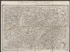
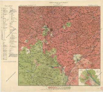
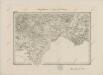
Umgebungen von Wischau und ungrisch Hradisch
1 : 144000 K.K. Militärisches Geographisches Institut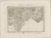
II. vojenské mapování 18
1 : 144000
Mapa okolí brněnského
1 : 150000 Brno-oblast (Česko) Líčka, Josef A. Píša
Die Kaiser Ferdinands-Nordbahn
Břeclav (Česko) Hölzl, Karl Karl Hölzl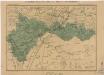
Generální mapa okresních hejtmanství

Mapa okolí brněnského
1 : 75000 Brno-oblast (Česko) Rothröckl, L. odbor Klubu čs. turistů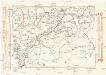
Komunikační mapa země Moravskoslezské
1 : 100000 Hodonín (Česko : oblast) Morslez. zem. výbor
Die Kaiser Ferdinand's Nordbahn
1 : 110000 Brno (Česko) Rohrmann, P. P. Rohrmann
Komunikační mapa země Moravskoslezské
1 : 100000 Znojmo (Česko : oblast) Morslez. zem. výbor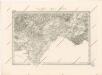
Special - Karte der Markgrafschaft Maehren und des Herzogthums Schlesien
II. vojenské mapování 18
1 : 144000
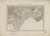
Auspitz und Nikolsburg.
from Spezialkarte der osterreichisch-ungarischen Monarchie.
Goding und Lundenburg.
from Spezialkarte der osterreichisch-ungarischen Monarchie.