Maps of Ruse

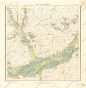
Zimnicea si Petrosani
Lambert-Cholesky sheet 4037 (Gogoşarii)
1 : 20000 Romanian military topographic map sheet under Lambert-Cholensky projection Serviciul Geografic al Armatei geo-spatial.org Serviciul Geografic al Armatei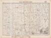
Lambert-Cholesky sheet 4036 (Găujani)
1 : 20000 Romanian military topographic map sheet under Lambert-Cholensky projection Serviciul Geografic al Armatei geo-spatial.org Serviciul Geografic al Armatei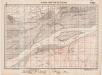
Lambert-Cholesky sheet 4035 (Pietroşani)
1 : 20000 Romanian military topographic map sheet under Lambert-Cholensky projection Serviciul Geografic al Armatei geo-spatial.org Serviciul Geografic al Armatei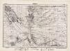
Lambert-Cholesky sheet 3937 (Brînceni)
1 : 20000 Romanian military topographic map sheet under Lambert-Cholensky projection Direcția Topografică Militară geo-spatial.org Direcția Topografică Militară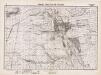
Lambert-Cholesky sheet 3936 (Bragadirul)
1 : 20000 Romanian military topographic map sheet under Lambert-Cholensky projection Serviciul Geografic al Armatei geo-spatial.org Serviciul Geografic al Armatei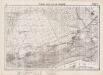
Lambert-Cholesky sheet 3935 (Zimnicia Est)
1 : 20000 Romanian military topographic map sheet under Lambert-Cholensky projection Serviciul Geografic al Armatei geo-spatial.org Serviciul Geografic al Armatei
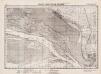
[Batin: Schlacht, 1828]
Bulgarien Batin Russisch-Türkischer Krieg <1828-1829>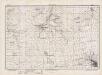
Lambert-Cholesky sheet 4038 (Trestenicu)
1 : 20000 Romanian military topographic map sheet under Lambert-Cholensky projection Direcția Topografică Militară geo-spatial.org Direcția Topografică Militară
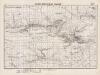
Pereprava russkich vojsk čerez Dunaj u Zimnicy 15 Ījunja 1877 goda
Rumänien Zimnicea Russisch-Türkischer Krieg <1877-1878> Flussüberquerung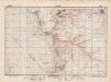
Lambert-Cholesky sheet 3938 (Pielea)
1 : 20000 Romanian military topographic map sheet under Lambert-Cholensky projection Direcția Topografică Militară geo-spatial.org Direcția Topografică Militară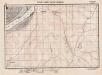
Lambert-Cholesky sheet 4135 (Tristenik)
1 : 20000 Romanian military topographic map sheet under Lambert-Cholensky projection Serviciul Geografic al Armatei geo-spatial.org Serviciul Geografic al Armatei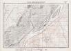
Lambert-Cholesky sheet 4136 (Arsache)
1 : 20000 Romanian military topographic map sheet under Lambert-Cholensky projection Serviciul Geografic al Armatei geo-spatial.org Serviciul Geografic al Armatei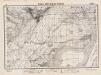
Lambert-Cholesky sheet 4137 (Slobozia)
1 : 20000 Romanian military topographic map sheet under Lambert-Cholensky projection Direcția Topografică Militară geo-spatial.org Direcția Topografică Militară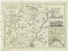
Karte von den durch die Waffen erroberten und durch den Frieden zu Szistow am 4 August 1791 von der ottomanischen Pforte an das Erzhaus Oestreich abgetrettenen Antheilen von Turkisch Kroatien und der Walachey
1 : 170000 Rumunsko Reilly, Franz Johann Josef von F. I. I. von Reilly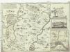
Karte von den durch die Waffen erroberten und durch den Frieden zu Szistow am 4 August 1791 von der ottomanischen Pforte an das Erzhaus Oestreich abgetrettenen Antheilen von Turkisch Kroatien und der Walachey
1 : 170000 Bulharsko Reilly, Franz Johann Josef von F. I. I. von Reilly
Nicopolis - Jantra
Mollova mapová sbírka Marsili, Luigi Ferdinando
[Ruse]
Bulgarien Ruse Russisch-Türkischer Krieg <1828-1829>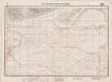
Lambert-Cholesky sheet 3934 (Vardim)
1 : 20000 Romanian military topographic map sheet under Lambert-Cholensky projection Serviciul Geografic al Armatei geo-spatial.org Serviciul Geografic al Armatei
[Donau : Russ. Militäroperation]
Bulgarien Ruse Russisch-Türkischer Krieg <1877-1878>
Lambert-Cholesky sheet 4138 (Stăneşti)
1 : 20000 Romanian military topographic map sheet under Lambert-Cholensky projection Serviciul Geografic al Armatei geo-spatial.org Serviciul Geografic al Armatei
Harta cailor de comunicatie din Judetul Vlaşca
1 : 200000 Rumunsko Ministerul Lucrărilor Publice
Harta cailor de comunicatie din Judetul Teleorman
1 : 200000 Rumunsko Ministerul Lucrărilor Publice
Harta Cailor de Comunicatie din Judetul Vlasca
Rumänien Vlaşca
Bulgarisch-rumänische Grenze
1 : 600000 Bulgarien, Rumänien, Grenze
Generalkarte von Zentraleuropa

XX, uit: General-Karte des oesterreichischen Kaiserstaates mit einem grossen Theile der angrenzenden Länder / durch Josef Scheda ... bearb. und hrsg
1 : 576000 Annotatie geografische gegevens: Maatstokken: oesterreichische Meilen, geografische oder deutsche Meilen, preussische Meilen, türkische Berri, französische Lieues, russische Werste; Maatstok per blad: wiener Klafter, öster. Meilen; Blad XIX: statistische en taalkundige informatie; Blad XIX: legenda [Wien : K.K. Militärisch-Geografisches Institut]
Harta Cailor de Comunicatie din Jud. Teleorman
Rumänien Teleorman
Lambert-Cholesky sheet 3836 (Suhaia)
1 : 20000 Romanian military topographic map sheet under Lambert-Cholensky projection Serviciul Geografic al Armatei geo-spatial.org Serviciul Geografic al Armatei