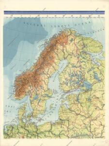
Maps of Scandinavia

Nástěnná mapa Evropy

La Scandinavie.
1 : 4200000 Lapie, M. (Pierre), 1779-1850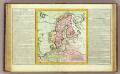
Suede, Dannemarck, Norwege.
1 : 8500000 Clouet, J. B. L. (Jean-Baptiste Louis), b. 1730
Carte generale de toute l'Europe, 2
1 Blatt : 56 x 46 cm J.M. Will
Sweden, Denmark, Norway and Finland.
1 : 6400000 Carey, Mathew
Suede, Danemark.
1 : 4650000 Andriveau-Goujon, J.
Nieuwe kaart van Noord-Europa / door A. de Moor
1 : 3250000 Moor, A. de (fl. 1920) [S.l. : Zijlstra]
Spesielle kart 129-3: Oversigtskart over fà ̧rste ordens trianguleringen og præcisionsnivellementet
1 : 2800000

Sweden & Norway.
1 : 7600000 Tanner, Henry S.
Sweden & Norway.
1 : 7603200 Tanner, Henry S.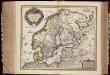
Tabula exactissima Regnorum Sueciae et Norvegiae, nec non Maris Universi Orientalis, terrarumq. adjacentium / summo studio ab Andrea Bureo Sueco in lucem edita ; noviter seria cura, singulariq. zelo, dedicatur humillimè Gustavo Adolpho ... a Nicolao Iohannide Piscatore ; Abraham Goos sculpsit
1 : 4700000 Annotatie: Origineel is Blad 141 in atlas factice; Annotatie geografische gegevens: Met 6 schaalstokken Claes Jansz. Visscher 1586/1587-1652; Andreas Bureus 1571-1646; Abraham Goos ca. 1589/90-1643 [Amsterdam : Nicolaus Johannis Piscator]
Spesielle kart 130-2: Oversigt over tætbebyggelse, stà ̧rre industrielle bedrifter og vigtige gruber ...
1 : 2800000
Suecia, Dania, Et Norvegia, Regna Europae Septentrionalia. [Karte], in: Le théâtre du monde, ou, Nouvel atlas contenant les chartes et descriptions de tous les païs de la terre, Bd. 1, S. 55.
1 Karte aus Atlas Blaeu, Willem Janszoon und Blaeu, Joan Blaeu, Willem Janszoon
Sueciae, Norvegiae, et Daniae, Nova Tabula. [Karte], in: Novus atlas absolutissimus, Bd. 1, S. 42.
1 Karte aus Atlas Janssonius Offizin
Suecia, Dania, Et Norvegia, Regna Europae Septentrionalia. [...] [Karte], in: Theatrum orbis terrarum, sive, Atlas novus, Bd. 1, S. 53.
1 Karte aus Atlas Blaeu, Joan Blaeu, Willem Janszoon
Scandia, Scandinavia.
1 : 3050000 Faden, William, 1750?-1836
Scandinavien bis zur calmarischen Union, 1397.
1 : 6000000 Spruner von Merz, Karl
Tabula exactissima Regnorum Sueciae et Norvegiae, nec non Maris Universi Orientalis [...] [Karte], in: Novus atlas absolutissimus, Bd. 1, S. 45.
1 Karte aus Atlas Janssonius Offizin
Homannův atlas světa
1 : 5000000
Nordeuropa 1871
Nordeuropa Kunz, Andreas ; Röss, Wolf ; Johnen, Bettina ; Moeschl, Joachim Robert
Scandinavien
Neuer Handatlas über alle Theile der Erde Kiepert, Heinrich Verlag von Dietrich Reimer
Schweden und Norwegen
1 : 11400000 Dánsko
Neueste Karte von Schweden und Norwegen
Grosser Hand-Atlas über alle Theile der Erde in 170 Karten Meyer, J. Verlag des Bibliographischen Instituts
Svecia, Dania, Et Norvegia, Regna Europae Septentrionalia [Karte], in: Novus Atlas, das ist, Weltbeschreibung, Bd. 1, S. 39.
1 Karte aus Atlas Blaeu, Joan Blaeu, Willem Janszoon
[63][63] Scandinaviae tabula comprehendens Regnorum Sueciae, Daniae et Norvegiae ..., uit: Atlas sive Descriptio terrarum orbis
Annotatie: Gedigitaliseerde versie. Amsterdam. Heiloo : Picturae (vervaardiger), 2015. tiff-bestand. Gedigitaliseerd: 07-01-2015; Origineel: Universiteitsbibliotheek Vrije Universiteit (XL.05127.-) ; Netherlands; Titelpagina ontbreekt Wit, Frederik de Amsterdam : Frederick de Wit
Der Westhandel Nordosteuropas in der Frühen Neuzeit
Europa (Nordost) Handel

Nordeuropa 1905
Nordeuropa Kunz, Andreas ; Röss, Wolf ; Johnen, Bettina ; Moeschl, Joachim Robert