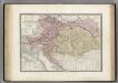
Maps of Carpathian Mountains

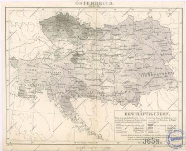
Bez titulu: Östereich

Bez titulu: Östereich

Austria.
1 : 4000000 Colton, G.W.
Bez titulu: Östereich

Austrian Empire.
1 : 4100000 Tanner, Henry S.
Übersichtblatt der Spezialkarte 1:75 000
Šolcova nejnovější politická a železniční cestovní mapa Rakousko – Uherska
Übersichts-Blatt zur Spezial-Karte der österr[eichisch] ung[arischen] Monarchie
Evropa střední K. u. k. Militärgeographisches Institut
Eisenbahnkarte von Oesterreich-Ungarn
1 : 1900000 Budapešť (Maďarsko) Bomsdorff, Theodor von Karl Prochaska
Eisenbahnkarte von Oesterreich-Ungarn
1 : 1900000 Evropa jihovýchodní Bomsdorff, Theodor von Karl Prochaska
Eisenbahnkarte von Oesterreich-Ungarn
1 : 1900000 Budapešť (Maďarsko) Bomsdorff, Theodor von Karl Prochaska
Austria.
1 : 4000000 Colton, G.W.
Österreich-Ungarn und Bosnien-Hercegovina
Eberle, Joseph
Österreichischer Kaiserstaat
1 : 3900000 Evropa jihovýchodní Theinert, A. Flemming, C. C. Flemming
Das Kaiserthum Oesterreich 1844
1 : 2900000 Evropa střední Verlage der k. k. Schulbücher Verschleiss Administration
Storchova nejnovější politická a železniční cestovní mapa Rakousko – Uherska

Österreich-Ungarn 1867 nach dem österreichisch-ungarischen Ausgleich
Österreich-Ungarn Österreichisch-ungarischer Ausgleich Kunz, Andreas ; Moeschl, Joachim Robert
Routenkarte der eisenbahnen von Österreich, Ungarn und Bosnien-Herzegowina
Eberle, Joseph
[Kaart], uit: Übersichtskarte der gewerblichen Unterrichts-Anstalten in Österreich / entw. u. gezeichnet von Karl Peucker ; bearb. von Adolf Müller
1 : 1700000 titelvariant: Die gewerblichen Unterrichts-Anstalten in Österreich; Annotatie: Omslagtitel: Die gewerblichen Unterrichts-Anstalten in Österreich; Opdrachtgever: K.K. Ministerium für Cultus und Unterricht; Met lijst van instellingen voor beroepsonderwijs Peucker, Karl; Müller, Adolf (fl. 1899) Wien : Artaria
Schulkarte von Österreich-Ungarn
Autriche, Hongrie.
1 : 2800000 Levasseur, E.
Übersichtskarte der k. k. österreichischen Staatsbahnen und der im Staatsbetriebe befindlichen Privatbahnen
Procházka, Karel
Prochaska's Eisenbahnkarte von Oesterreich-Ungarn für 1894
1 : 1500000 Evropa jihovýchodní Karl Prochaska
Prochaska's Eisenbahnkarte von Oesterreich-Ungarn für 1892
1 : 1500000 Evropa jihovýchodní Karl Prochaska
Oesterreich-Ungarn Eisenbahn-Karte
1 : 1500000 Budapešť (Maďarsko) Bomsdorff, Theodor von Karl Prochaska
Oesterreich-Ungarn Eisenbahn-Karte
1 : 1500000 Budapešť (Maďarsko) Bomsdorff, Theodor von Karl Prochaska
Oesterreich-Ungarn Eisenbahn-Karte
1 : 1500000 Rakousko-Uhersko Bomsdorff, Theodor von Karl Prochaska
Oesterreich-Ungarn Eisenbahn-Karte
1 : 1500000 Rakousko-Uhersko Bomsdorff, Theodor von Karl Prochaska
Mocnářství Rakousko - Uherské