Maps of Edingen-Neckarhausen

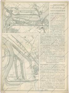
Mannheim

Meßtischblatt [6517] : Ladenburg, 1910
1 : 250000 Ladenburg. - 2. Aufl., erg. 1904, einz. Nachtr. 1910. - 1:25000. - Leipzig: Giesecke & Devrient, 1910. - 1 Kt.
Meßtischblatt 22 : Ladenburg, 1881
1 : 250000 Ladenburg. - 1:25000. - Leipzig: Giesecke & Devrient, 1881. - 1 Kt.
Mannheim

Vorstellung der Linie u[nd] Inondation von Bruchsahl bis Ketsch
1 : 60000 Mollova mapová sbírka Riecke, Gustav Friedrich Homann, Johann Baptista - dědici
Le Flambeau de la Guerre Allumee au Rhin
Mollova mapová sbírka Delisle, Guillaume Schenk, Peter II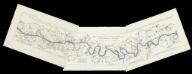
[Lauf des Rheins von Neuburg bis unterhalb Mannheim im Anfange des Jahres 1837] : Tab. 1: Hydrographische Charte vom Lauf des Rheins v. Neuburg bis Sondernheim die im Jahre 1817 angefangen Rectification desselben enthaltend. 2: Hydrographische Carte vom Lauf des Rheins von Sondernheim bis Otterstatt mit Rücksicht auf die Rectification desselben . 3: Hydrographische Carte vom Lauf des Rheins mit Rücksicht auf die Rectification desselben : Distrikte v. Waldsee bis an die Hessischen Grenze
1 : 80000 [S.l.] : Grosh. Bad. Landw. Wochenblatt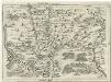
Geographica Provinciarum Sveviae Descriptio =
Mollova mapová sbírka Hurter, Johann Christoph Bodenehr, Gabriel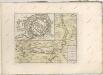
Carte von Linie und Innondation, von Bruchsal bis Kethsch, woselbst die Innondation in Rhein fließet.
1 : 65000 Mollova mapová sbírka Riecke, Gustav Friedrich Bodenehr, Gabriel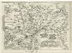
Geographica Provinciarum Sveviae Descriptio =
Mollova mapová sbírka Hurter, Johann Christoph Bodenehr, Johann Georg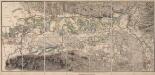
[Topographische Charte der Gegend zwischen Rhein, Neckar und Mayn]
Meister, G.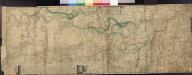
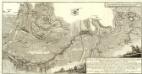
Le Cours Du Rhin Depuis Spire juisqu'à Mayence, les marches et Contremarches de l'Armée Francoise et les Camps y sont marqués Come aussi de l'Armée Alliée du coté du Main l'ann 1743 avec la Situation de l'Odewwald et du Berg Straass
Denis, Ferdinand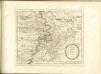
Accurate Special-Charte der Gegend des Rheins, von Ettlingen, Carls Ruhe, Philippsburg, Bruchsal, bis Mannheim, etc. Entworffen
Riecke, Gustav Friedrich; Ostertag, Heinrich Jonas; Cöntgen, Bartolomäus Anton Brönner
Territorium Seculare Episcopatus Wormatiensis Tabula Geographica
1 : 130000 Mollova mapová sbírka Homann, Johann Baptist Homann, Johann Baptista - dědici
Section Worms, uit: Charte von dem Grossherzogtum Hessen und dem Herzogtum Nassau / trigonometrisch aufgenommen und hrsg. von C.L.P. Eckhardt
1 : 200000 titelvariant: Karte von Hessen und Nassau Eckhardt, C. L. P Darmstadt : Joh. Wilh. Heyer
Partie du Cours du Palatinat du Rhin Levesché de Spire et de Worms les Comté de Spanheim et de Linange levée Sur les lieu
1 : 160000 Mollova mapová sbírka Baillieul, Gaspard Bailleul, Gaspard
Exact und Gantz accurater Plan
1 : 570000 Mollova mapová sbírka Geyer, Friedrich W. Berndt, Johann Christoph Geyer, Friedrich
Le Cours du Rhein, depuis Spire jusqu'a Mayence
1 : 180000 Mollova mapová sbírka Fer, Nicolas de Fer, Nicolas de

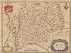
ERPACH | COMITATVS
[Amsterdam : Joan Blaeu]
Special Carte des Rheinlaufes von Speier bis Bingen nebst den angraentzenden Gegenden von beiden Ufern bis an die Gebirge
1 : 250000 Bingen (Německo) Dewarat, Peter Verhelst, Aegid Schwan und Götz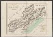
Erpach Comitatus. [Karte], in: Gerardi Mercatoris et I. Hondii Newer Atlas, oder, Grosses Weltbuch, Bd. 1, S. 227.
1 Karte aus Atlas Mercator, Gerhard und Hondius, Jodocus Jansson, Jan
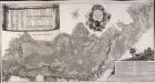
Suevia Universa
1 : 170000 Mollova mapová sbírka Michal, Jacques de Seutter, Matthäus Seutter, Matthäus
Carte Particuliere des Pays qui sont situéz entre le Rhein, la Saare, la Moselle, et la Basse Alsace
1 : 150000 Mollova mapová sbírka Mortier, Pieter Mortier, Pierre
Erpach Comitatus. [Karte], in: Novus atlas absolutissimus, Bd. 2, S. 192.
1 Karte aus Atlas Janssonius Offizin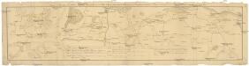
Camps et marches de l'armée imperiale com[m]andée par S.A.S. le prince de Savoye pour retourner de Wesenthal prés de Philippsbourg, et aller passer le Rhein a Mayence, l'armée de France étant campé a Oppenheim prés de céte ville
Mannheim (Německo) Müller, Johann Conrad
Territorium Seculare Episcopatvs Spirensis una cum terris adiacentibus
1 : 140000 Mollova mapová sbírka Blödtner, Cyriak Homann, Johann Baptista - dědici