Maps of Jihočeský

Kraj Českobudějovický

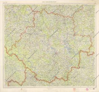
Jihočeský kraj

Jihočeský kraj

Regni Bohemiae Circulus Bechinensis
1 : 264000 Bechyně-oblast (Česko) Müller, Johann Christoph ab Homannianis Heredibus
Regni Bohemiae Circulus Bechinensis
1 : 264000 Bechyně-oblast (Česko) Müller, Johann Christoph ab Homannianis Heredibus
Provincia Bechinensis
Bechyně-oblast (Česko) Bernardi, Augustin Augustin Bernardi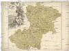
Provincia Bechinensis
Bechyně-oblast (Česko) Müller, Johann Christoph
Regni Bohemiae Circuli Taborensis et Budweisensis...

Regni Bohemiae Circulus Kaurzimensis
1 : 180000 Kouřim-oblast (Česko) Müller, Johann Christoph ab Homannianis Heredibus
Regni Bohemiae Circuli Taborensis et Budweisensis
1 : 200000 Tábor-oblast (Česko) Müller, Johann Christoph ab Homannianis Heredibus
Bechiner Kreis
Bechyně-oblast (Česko) Berndt, Johann Christoph Anton Elsenwanger
Bechiner Kreis
Bechyně-oblast (Česko) Berndt, Johann Christoph Anton Elsenwanger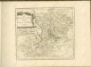

Circulus Budvicensis pars regni Bohemiae
1 : 253000 České Budějovice-oblast (Česko) Henatsch, Ant. Berka, Jan Peter franza [sic]
Circulus Budvicensis pars regni Bohemiae
1 : 253000 České Budějovice-oblast (Česko) Henatsch, Ant. Berka, Jan
Circulus Budvicensis pars regni Bohemiae
1 : 253000 České Budějovice-oblast (Česko) Henatsch, Ant. Berka, Jan Peter franza [sic]
Circulus Budvicensis pars regni Bohemiae
České Budějovice-oblast (Česko) Henatsch, Ant. Berka, Jan Peter franza [sic
Provincia Bechinensis
1 : 217000 Mollova mapová sbírka Erber, Bernardinus Winkler, Johann Christoph Kurzböck, Josef von
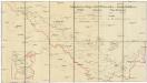
Karte des Taborer und Budweiser Kreises im österreichischen Kronlande Böhmen
1 : 285000 Tábor-oblast (Česko) Obentraut, Maxmilian Friedrich Kretzschmar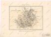
Der Budweiser Kreis
Schutzvereins-Ortsgruppen des Böhmerwaldes und Deutsch-Südböhmens
1 : 200000 Čechy jižní (Česko)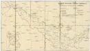
Deutsche Gemeinden u. Pfarren Südböhmens
1 : 200000 Čechy jižní (Česko) Blechinger, L.
Charte vom Budweiser Kreise des Königreiches Böheim
1 : 241000 České Budějovice-oblast (Česko) Kreibich, František Jakub Jindřich Enders, C. W. C.W. Enders
Charte vom Budweiser Kreise des Königreiches Böheim
1 : 241000 České Budějovice-oblast (Česko) Kreibich, František Jakub Jindřich Enders, C. W. C.W. Enders
Charte vom Budweiser Kreise des Königreiches Böheim
1 : 241000 České Budějovice-oblast (Česko) Kreibich, František Jakub Jindřich Enders, C. W. C.W. Enders
Charte vom Budweiser Kreise des Königreiches Böheim
1 : 241000 České Budějovice-oblast (Česko) Kreibich, František Jakub Jindřich Enders, C. W. C.W. Enders
Charte vom Budweiser Kreise des Königreiches Böheim
1 : 241000 České Budějovice-oblast (Česko) Kreibich, František Jakub Jindřich Enders, C. W. C.W. Enders
Darstellung des Gesichtskreises von dem Fürst Iosephs Thurme auf dem Schöninger im Planskerwalde in Böhmen
1 : 330000 Blanský les (Česko) Falta, Joseph Hafner, Joseph
Darstellung des Gesichtskreises von dem Fürst Iosephs Thurme auf dem Schöninger im Planskerwalde in Böhmen
1 : 330000 Blanský les (Česko) Falta, Josef Hafner, Josef