Maps of Italy

Carte Synoptique au tarif de l'Europe centrale trafic voyageurs, des bagages et des colis express

Carte des états slaves rendus indépendants par Samo, et groupés autour de lui (an 625 à 650), en face du royaume réduit des Avars, enserré à l’est par les Khazars et les Bulgares, et au sud et à l’ouest par les Slaves que l’empereur Héraclius avait établis au sud du Danube
Ostmitteleuropa Tschechische Republik Slawen Awaren Samo
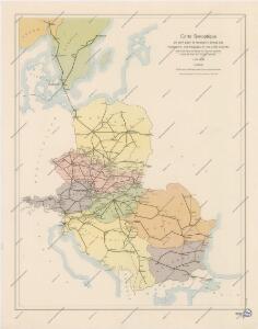
Německo - ruské pohraničí a Balkán

Karta razselenija [sic] Slavjan v IX stol
1 : 12600000 Evropa východní Kočubinskij, Aleksandr Aleksandrovič C.I. Mal'cov
Composite: Central Europe.
1 : 2000000 John Bartholomew and Son
Střední a jihovýchodní Europa v druhé polovici XIV. stol.

Nordischer Krieg 1700 - 1721
Ostmitteleuropa, Nordeuropa, Nordischer Krieg <1700-1721>
Die grossen Friedensschlüsse II (1735 - 1812). Frankreichs, Rußlands und Englands Vorschreiten 1801-1812
1 : 20000000 Mitteleuropa, Osteuropa, Napoleonische Kriege
Národopisná mapa Evropy
Evropa Ryšavý, Jaroslav Mollo, Tranquillo
Conspectus Generalis omnium earum partium quae unquam ad Imperium Francicum vel Franco-Romanum demum Romano-Germanicum diversis temporum periodis pertinuerunt.
1 : 11000000 Mollova mapová sbírka Homann, Johann Baptist Homann, Johann Baptista - dědici
Octava Europe Tabula [Karte], in: [Clavdii Ptholomei Cosmographi ...], S. 278.
1 Karte aus Atlas Nicolaus Germanus [und Ptolemaeus, Claudius]
Ethnographical map of central & south eastern Europe. 1916.
1 : 4000000 First World War ethnographical map of central & south eastern Europe. 1916. War Office
[Octava Europe tabula] [Karte], in: Clavdii Ptholomei Viri Alexandrini Cosmographie, S. 152.
1 Karte aus Atlas Nicolaus Germanus [und Ptolemaeus, Claudius]
Ost- und Mitteleuropa i.d. zweiten Hälfte d. 18. Jahrhunderts. Die polnischen Teilungen
1 : 12000000 Polen-Litauen, Ostmitteleuropa, Teilungen Polens
Polen, Litthauen und das Gebiet des deutsche Ordens in den Jahren 1386 - 1480
1 : 6000000 Polen-Litauen, Preußen (Ordensstaat)
Svět staroslovanský
Evropa střední a východní Milbauer, Emanuel Vlastimil Šafařík, Pavel Josef
Mittel-Europa
1 : 3000000 Evropa střední G. Freytag & Berndt
30. Mitteleuropa nach Beendigung des nordischen Krieges im Jahre 1721
Mitteleuropa, Ostmitteleuropa, Nordischer Krieg <1700-1721>
Ukraine - Franken : heutige administrative Grenzen
Ukraine, Franken, Verwaltungsgliederung Scheidig, Holger
29. Mitteleuropa im Jahre 1650
Mitteleuropa
Map of the Post-Route to & from St. Petersburgh
1 : 24000000 Osteuropa Deutschland Polen Russland Reiseweg Postroute
Mitteleuropa
1 : 3000000 Evropa střední Kartogr. Anstalt G. Freytag & Berndt
Verbreitung der Slaven um 900
Osteuropa Slawen Anton, J.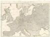
Wege-Karte durch den grösten und wichtigsten Theil Europa's
Evropa Schmidt, Johann Marius Friedrich Kliewer, Heinrich Simon Schropp et Comp.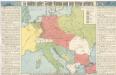
So wollten unsere Feinde Europa nach dem Kriege gestalten

32. Mitteleuropa nach dem Reichsdeputationshauptschluss im Jahre 1803
Mitteleuropa Reichsdeputationshauptschluss
Conspectus Generalis omnium earum partium quae unquam ad Imperium Francicum vel Franco-Romanum demum Romano-Germanicum diversis temporum periodis pertinuerunt.
1 : 11000000 Mollova mapová sbírka Homann, Johann Baptist Homann, Johann Baptista - dědici
Ethnografická mappa
Evropa Merklas, Václav V. Merklas