Maps of Transdanubia

Letecká mapa Evropy

Eisenbahnkarte der k.u.k. oesterreichisch-ungarischen Monarchie

Pannonia svperior svb Romanis ab Avgvsto ad finem saecvli IIII
Panonie Gruber, P. Leop. Grimm, M.
Austria Antiqva Cis Danvbiana Pannonica
1 : 2360000 Mollova mapová sbírka Clüver, Philipp Fuhrmann, Mathias
General Post und Strassen Karte des Herzoghtums Steyermark
1 : 390000 Mariazell (Rakousko) Schulz, R. A. Artaria
General Post und Strassen Karte des Herzoghtums Steyermark
1 : 390000 Mariazell (Rakousko) Schulz, R. A. Artaria
Oesterreich, Steyermark, Illyrien. Ungarn. Comitate: Wieselburg, Oedenburg, Eisenburg, Szalader, Schimegher und Preßburger
Ungarn Verkehrsweg
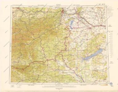
Wien, Graz, Budapest
1 : 750000 Budapešť (Maďarsko : oblast) Karl, Ed. K. u. k. Militärgeographisches Institut
Wien, Graz, Budapest
1 : 750000 Budapešť (Maďarsko : oblast) K.u.k. militär-geographisches Institut
Wien, Graz, Budapest
1 : 750000 Budapešť (Maďarsko : oblast) K. u. k. militär-geographisches Institut
Übersichtskarte von Mittel - Europa

Stiria ducatus
1 : 500000 Štýrsko (Rakousko) Seutter, Matthäus Matth. Seutter

Strassen- und Eisenbahnkarte des oesterreichischen Kaiserthumes
1 : 864000 Blatt 6 Schaller, G. K.K. Militärisch-Geografisches Institut, Karten-Evidenthaltungs-Abteilung
Slovinci ve Štýrsku, v Korutanech, v Kraňsku a v Přímoří
Jaderské moře (oblast) Brož, Josef Československá společnost zeměvědná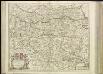
[38][38] Circuli Austriaci pars septentrionalis ..., uit: Atlas sive Descriptio terrarum orbis
Annotatie: Gedigitaliseerde versie. Amsterdam. Heiloo : Picturae (vervaardiger), 2015. tiff-bestand. Gedigitaliseerd: 07-01-2015; Origineel: Universiteitsbibliotheek Vrije Universiteit (XL.05127.-) ; Netherlands; Titelpagina ontbreekt Wit, Frederik de Amsterdam : Frederick de Wit
Post und Eisenbahnkarte der Österreichisch-Ungarischen Monarchie

Das Herzogthum Steyermark
1 : 740000 Štýrsko (Rakousko) Kauperz, Joh. V. bey Joh. V. Kauperz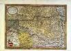
Avstriae dvcatvs chorographia
1 Karte : Kupferdruck ; 31 x 44 cm Lazius; Ortelius s.n.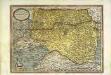
Avstriae dvcatvs chorographia
1 Karte : Kupferdruck ; 31 x 44 cm Lazius; Ortelius s.n.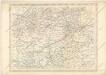
Strassen und Eisenbahnkarte des oesterreichischen Kaiserthumes
Austriae Descirp. [Karte], in: Theatrum orbis terrarum, S. 257.
1 Karte aus Atlas Ortelius, Abraham Vrients, Jan Baptista
[Wien-Ofen].
1 : 576000 Rakousko Blumtritt, H. Oesfeld, C. W.
Karte von Herzogthum Steyermark
1 : 860000 Štýrsko (Rakousko) Florian Mollo
Niederungern
Maďarsko západní Kipferling, Karl Joseph Berken von Ottendorff, Johann im Verlage des Kunst- und Industrie Comptoirs
Niederungern
Maďarsko západní Kipferling, Karl Joseph Berken von Ottendorff, Johann im Verlage des Kunst- und Industrie Comptoirs
Ducatus Stiriae Novissima Tabula
1 : 470000 Mollova mapová sbírka Vischer, Georg Matthaeus Homann, Johann Baptista - dědici
Stiria [Karte], in: Gerardi Mercatoris Atlas, sive, Cosmographicae meditationes de fabrica mundi et fabricati figura, S. 475.
1 Karte aus Atlas Mercator, Gerhard Montanus, Petrus
Stiria [Karte], in: Gerardi Mercatoris et I. Hondii Newer Atlas, oder, Grosses Weltbuch, Bd. 1, S. 349.
1 Karte aus Atlas Mercator, Gerhard und Hondius, Jodocus Jansson, Jan