Maps of Pardubice
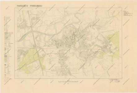
Pardubitz (Pardubice)
Orientační plán královského komorního města Pardubic
1 : 7400 Pardubice (Česko) Mužík, Jan Jan Liebich
Mapa návrhu na úpravu řeky Labe u Pardubic
1 : 2880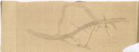
Mapa návrhu na úpravu řeky Labe v Pardubicích
1 : 2880
Indikační skica mapy stabilního katastru pro město Pardubice XII.
1 : 2880
Pardubitschek - c5634-1-002 - Kaiserpflichtexemplar der Landkarten des stabilen Katasters
1 : 2880
Pardubitschek - c5634-1-001 - Kaiserpflichtexemplar der Landkarten des stabilen Katasters
1 : 2880
Indikační skica mapy stabilního katastru pro obec Pardubičky II.
1 : 2880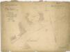
Mapa promýcených porostů Zelenobranského hájenství
1 : 2880
Sádky v Pardubicích
1 : 1000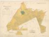
Mapa porostů Zelenobranského hájenství
1 : 2880
Indikační skica mapy stabilního katastru pro město Pardubice XI.
1 : 2880
Obecní lesy města Pardubic, Zelenobranské hájenství
1 : 2880
Indikační skica mapy stabilního katastru pro město Pardubice VI., ad III., ad IX.
1 : 2880
Indikační skica mapy stabilního katastru pro obec Živanice V.
1 : 2880
Indikační skica mapy stabilního katastru pro město Pardubice VI.
1 : 2880
Indikační skica mapy stabilního katastru pro obec Studánka II.
1 : 2880
Studanka - c7497-1-002 - Kaiserpflichtexemplar der Landkarten des stabilen Katasters
1 : 2880
Studanka - c7497-1-001 - Kaiserpflichtexemplar der Landkarten des stabilen Katasters
1 : 2880
Indikační skica mapy stabilního katastru pro město Pardubice III.
1 : 2880
Indikační skica mapy stabilního katastru pro obec Studánka I.
1 : 2880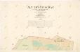
Indikační skica mapy stabilního katastru pro obec Staré Jesenčany I.
1 : 2880
Indikační skica mapy stabilního katastru pro obec Pardubičky I., ad II., III.
1 : 2880
Indikační skica mapy stabilního katastru pro obec Trnová II.
1 : 2880
Pardubitz - c5633-1-006 - Kaiserpflichtexemplar der Landkarten des stabilen Katasters
1 : 2880
Pardubitz - c5633-1-007 - Kaiserpflichtexemplar der Landkarten des stabilen Katasters
1 : 2880
Pardubitz - c5633-1-003 - Kaiserpflichtexemplar der Landkarten des stabilen Katasters
1 : 2880
Pardubitz - c5633-1-009 - Kaiserpflichtexemplar der Landkarten des stabilen Katasters
1 : 2880
Pardubitz - c5633-1-011 - Kaiserpflichtexemplar der Landkarten des stabilen Katasters
1 : 2880
Pardubitz - c5633-1-005 - Kaiserpflichtexemplar der Landkarten des stabilen Katasters
1 : 2880
Pardubitz - c5633-1-002 - Kaiserpflichtexemplar der Landkarten des stabilen Katasters
1 : 2880
Pardubitz - c5633-1-004 - Kaiserpflichtexemplar der Landkarten des stabilen Katasters
1 : 2880
Pardubitz - c5633-1-001 - Kaiserpflichtexemplar der Landkarten des stabilen Katasters
1 : 2880
Pardubitz - c5633-1-010 - Kaiserpflichtexemplar der Landkarten des stabilen Katasters
1 : 2880