Maps of Jihočeský

Generalkarte von Zentraleuropa

Südlicher Theil von Boehmen enthaltend den Klatttauer, Berauner, Taborer, Prachiner und Budweiser Kreis
Čechy jižní (Česko) Kindermann, Joseph Karl Kunst= und Industrie Comptoir
Südlicher Theil von Boehmen enthaltend den Klattauer, Berauner, Taborer, Prachiner und Budweiser Kreis
Čechy jižní (Česko) Kindermann, Joseph Karl im Verlage des Kunst- und Industrie Comptoirs
Regni Bohemiae Circulus Prachinensis
1 : 200000 Prácheňsko (Česko) Müller, Johann Christoph Homannianorum Heredum
Regni Bohemiae Circulus Prachinensis
1 : 200000 Prácheňsko (Česko) Müller, Johann Christoph Homannianorum Heredum
Carte topographique d'Allemagne contenant une partie du Royaume de Boheme
1 : 220000 Jihočeský kraj (Česko) Facius, Johann Gottlieb I. W. A. Iaeger
Carte topographique d'Allemagne contenant une partie du royaume de Boheme, savoir les cercles de Beraun, Kaurzin
1 Karte : Kupferdruck ; 46 x 62 cm Jaeger; Facius se vend chez I. W. A. Iaeger
Jihočeský kraj

Karte des Taborer und Budweiser Kreises im österreichischen Kronlande Böhmen
1 : 285000 Tábor-oblast (Česko) Obentraut, Maxmilian Friedrich Kretzschmar
Kraj Českobudějovický
Militair Karte von Süd-Deutschland in 20 Sectionen
1 : 400000 8. Section Coulon, Alois von A. von Coulon
Allgemeiner Übersichtsplan der böhmischen Kohlenbahn
1 : 347000 Čechy (Česko)
Jihočeský kraj

Regni Bohemiae Circulus Bechinensis
1 : 264000 Bechyně-oblast (Česko) Müller, Johann Christoph ab Homannianis Heredibus
Regni Bohemiae Circulus Bechinensis
1 : 264000 Bechyně-oblast (Česko) Müller, Johann Christoph ab Homannianis Heredibus
Regni Bohemiae Circuli Taborensis et Budweisensis...
Schutzvereins-Ortsgruppen des Böhmerwaldes und Deutsch-Südböhmens
1 : 200000 Čechy jižní (Česko)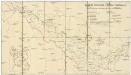
Deutsche Gemeinden u. Pfarren Südböhmens
1 : 200000 Čechy jižní (Česko) Blechinger, L.
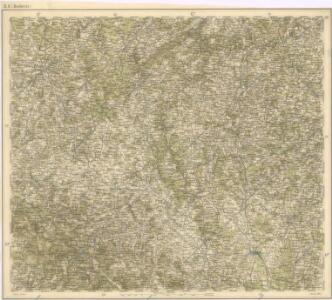
Tabor 117, uit: Special-Karte von Mittel-Europa / nach amtlichen Quellen bearbeitet von W. Liebenow
1 : 300000 titelvariant: W. Liebenow's Mittel-Europa; Annotatie: Titel boven de bladen: W. Liebenow's Mittel-Europa Johannes Wilhelm Liebenow 1822-1897 Frankfurt a. M. : Ludwig Ravenstein
Deutsche Strassenprofilkarte für Radfahre.
Plzeň-oblast (Česko) Scheiner, Josef Mittelbach, R. J.C. Hinrichs
Prachiner Kreis

Prachenský kraj w Kralowstwí českém

Prachenský kraj w Králowství českém
1 : 140000 Prácheňsko (Česko) Loth, Johann Schönfelder, Franz von Friedrich Kretzschmar
Prachenský kraj w Králowství českém
1 : 140000 Prácheňsko (Česko) Loth, Johann Schönfelder, Franz von Friedrich Kretzschmar
Prachenský kraj w Králowství českém
1 : 140000 Prácheňsko (Česko) Loth, Johann Schönfelder, Franz von Friedrich Kretzschmar
Prachiner Kreis

Prachenský kraj w Kralowstwí českém

Regni Bohemiae, Circulus Prachinensis ex Müllerianis...

Prachenský kraj w králowstwí českém
1 : 145000 Jihočeský kraj (Česko) Loth, Johann Schönfelder, Franz von Friedrich Kretzschmar
Special-Karte des Piseker Kreis
1 : 241000 Písek-oblast (Česko) Schmidt, Eduard Wend. Morauer
Special-Karte des Piseker Kreis - resp. politischen Verwaltungsbezirkes im Boehmen
1 : 240000 Písek-oblast (Česko) Schmidt, Eduard Wend. Morauer