Maps of Neustift im Stubaital

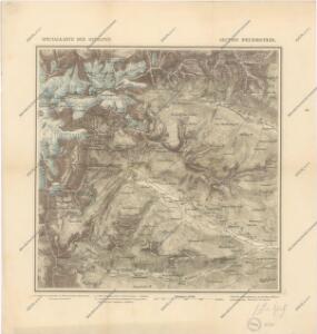
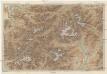
Spezialkarte der Ostalpen

Feuerstein
1 : 50000 Stubaiské Alpy (Itálie a Rakousko : pohoří) Deutscher und Oesterreichischer Alpenverein
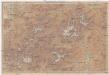
Solden und St. Leonhard (Tirol).
from Spezialkarte der osterreichisch-ungarischen Monarchie.
Brenner-Bahn
1 : 96000 Bolzano (Itálie) Fr. Unterberger's Kunsthandlung
Sterzing und Franzensfeste (Tirol).
from Spezialkarte der osterreichisch-ungarischen Monarchie.
[Stubaier Alpen]
1 : 100000 Stubaiské Alpy (Itálie a Rakousko : pohoří) Freytag & Berndt
Carte du Tyrol
1 : 150000 West-Blatt Anich, Peter par le Dépôt Général de la Guerre
B.Z. - Karte von Oesterreich

Meran
1 : 200000 1 Karte entworfen und bearbeitet von Woerl ; in Stein gestochen unter seiner Leitung ; Lithographie von B. Herder Herder, Freiburg im Breisgau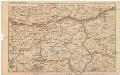
Strecke
Bludenz (Rakousko) K. k. Österreichische Staatsbahnen
Engadin-Orientbahn
1 : 250000 1:250 000 Schweiz Eidgenössisches Topographisches Bureau Eidg. Topographisches Bureau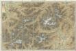
Karte der West - Tiroler und Engadiner – Alpen
Karte der West-Tiroler und Engadiner Alpen
1 : 250000 Engadin (Švýcarsko) Ravenstein, Ludwig L. Ravenstein
Vorarlberg - Oetzthaler Alpen - Brenner
1 : 850000 Bibliographisches Institut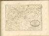

Generalkarte von Zentraleuropa
Karte der West-Tiroler und Engadiner Alpen
1 : 250000 Engadin (Švýcarsko) Ravenstein, Ludwig Geographische Anstalt von L. Ravenstein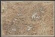
Karte der West-Tiroler und Engadiner Alpen
1 : 250000 Ravenstein, Ludwig Geographische Anstalt von L. Ravenstein
Tirolis
Mollova mapová sbírka Hoffmann, Johannes Hoffmann, Johann
Carte topographique d'Allemagne contenant une partie des Grisons, du comté de Tyrol, du comté de Pludentz, et le comté de Bormio
1 Karte fait par I. W. Iaeger chez l'auteur, Francfort sur le Mein
Atlas Tyrolensis
Mollova mapová sbírka Anich, Peter
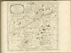
Tirol, Samt denen angrenzend- und einverleibten Ländern nach möglichster Richtigkeit
1 : 470000 Mollova mapová sbírka Riegel, Christoph
Charte des Kanton Basel
1 : 161000 Basilej-město (Švýcarsko : kanton) Herz, W. Gleditsch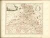

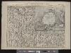
Comitatus Tyrolis Tabula
1 : 1000000 Mollova mapová sbírka Engelbrecht, Christian Pfeffel, Johann Andreas
Comitatus Tyrolis Tabula
1 : 1000000 Mollova mapová sbírka