Maps of Ryükyü Isands

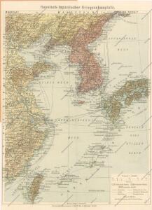
Russisch - Japanische Kriegsschauplatz

China (Östl. Theil), Korea und Japan
Handatlas über alle Theile der Erde und über das Weltgebäude Stieler, Adolf Justus Perthes
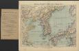
[Ost-China, Korea und Japan]
Adolf Stieler's Handatlas über alle Theile der Erde und über das Weltgebäude Stieler, Adolf Justus Perthes
99-100. Cina Propria, Corea.
1 : 5000000 Touring club italiano
Iaponia [Karte], in: Gerardi Mercatoris Atlas, sive, Cosmographicae meditationes de fabrica mundi et fabricati figura, S. 541.
1 Karte aus Atlas Mercator, Gerhard Montanus, Petrus
Korea, Nordost-China und Süd-Japan
1 : 4500000 Annotatie geografische gegevens: 3 schaalstokken; 3 inzetkrt.: Peking en omgeving. - 1:1.000.000. Tokio en omgeving. - 1:1.000.000. Söul en omgeving. - 1:1.666.666 Glogau : Carl Flemming
Kaart van Oost-Azië / J. Wackie
1 : 5000000 Annotatie: Met versterkte plaatsen (door landmacht en zeemacht); Gegevens verzameld over de periode/Data collected over the period: 1904; Annotatie geografische gegevens: Legenda J. Wackie Amsterdam : J.H. de Bussy
Russisch - Japanische Kriegsschauplatz

Korea, Nordost-China und Süd-Japan
1 : 4500000 Korea Carl Flemming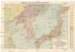
Dmychova mapa rusko-japonského bojíště [sic]
1 : 5000000 Asie východní Dmych, Josef J. Dmych
JAPANESE EMPIRE
Korea, Nordost-China und Süd-Japan
1 : 4500000 [...] bearbeitet von A. Herrich Glogau : Carl Flemming

Mapa k rusko-žaponské válce
1 : 6400000 Japonsko Roudný, R.
Pecheli, Xansi, Xantung, Honan, Nanking, In plaga Regni Sinensis inter Septentrionem ac Orientem Ceciam versus sitae Provinciae. [Karte], in: Novus atlas absolutissimus, Bd. 6, S. 127.
1 Karte aus Atlas Janssonius Offizin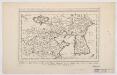
Carte du Katay : ou, Empire de Kin, pour servir a l'histoire de Jenghiz Khan ; raportée dans l'histoire generale des voyages, tirée de l'Anglois = Kaart van Kitay, of 't Ryk der Kin, dienende tot de historie van Jenghiz Khan, uit de Engelsche in dit Bestek gebragt
1 : 1500000 Bellin, Jacques Nicolas, 1703-1772 Pierre de Hondt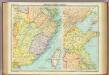
Eastern China - political.
1 : 3000000 John Bartholomew and Son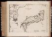
Iaponia Regnvm
1 : 4000000 Annotatie: Cum privilegio Sacrae Caesarae Majestatis & Ordinum Belgicae Foederatae; Origineel is Blad 197 in atlas factice; Annotatie geografische gegevens: Met 2 schaalstokken Amsterdam : Joannes Blaeu]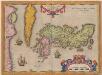
Iaponiae Insulae Descriptio. [Karte], in: Theatrum orbis terrarum, S. 301.
1 Karte aus Atlas Ortelius, Abraham
Iaponia Regnum [Karte], in: Novus atlas Sinensis, S. 240.
1 Karte aus Atlas Martini, Martino Blaeu, Joan
IAPONIA | REGNVM.
[Amsterdam : Joan Blaeu]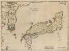
Iaponia Regnum. [Karte], in: Novus atlas absolutissimus, Bd. 11, S. 238.
1 Karte aus Atlas Janssonius Offizin
Položenīe storon vo 2j polovině marta 1904 g.
China Mandschurei Russisch-Japanischer Krieg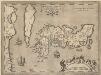
Iaponiae Insulae Descriptio. [Karte], in: Theatrum orbis terrarum, S. 396.
1 Karte aus Atlas Ortelius, Abraham Vrients, Jan Baptista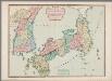
The Empire of Japan divided into seven principal parts and subdivided into sixty six kingdoms : with the Kingdom of Corea, from Kempfer and the Portuguese
Annotatie: Uit: General atlas. - London : Robert Sayer, 1790; Lit.: Japan mit den Augen des Westens gesehen / hrsg. von Lutz Walter, p. 198; Tooley's dictionary of mapmakers, 1979, p. 380 London : Laurie & Whittle
Pecheli, Xansi, Xantung, Honan, Nanking, in plaga Regni Sinensis inter Septentrionem ac Orientem Ceciam versus sitae provinciae
1 : 3200000 Amstelodami : venales apud P. Schenk et G. Valk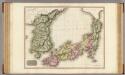
Japan.
1 : 2770000 Pinkerton, John, 1758-1826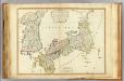
Japan, Korea.
1 : 3000000 Robert Laurie & James Whittle
Japan
1 : 6000000 Arrowsmith, Aaron Jr.