Maps of Landkreis Cham
Mappa geographica regni Bohemiae in duodecim circulos divisae ...
Müllerova mapa Čech
1 : 132000
Taus 116, uit: Special-Karte von Mittel-Europa / nach amtlichen Quellen bearbeitet von W. Liebenow
1 : 300000 titelvariant: W. Liebenow's Mittel-Europa; Annotatie: Titel boven de bladen: W. Liebenow's Mittel-Europa Johannes Wilhelm Liebenow 1822-1897 Frankfurt a. M. : Ludwig Ravenstein
165. Cham, uit: Topographische Uebersichtskarte des Deutschen Reiches / herausgegeben v. d. Kartogr. Abt. d. Königl. Preuß. Landesaufnahme
1 : 200000 titelvariant: Topogr. Übersichtskarte des Deutschen Reiches; Annotatie: Titel boven bladen ook: Topogr. Übersichtskarte des Deutschen Reiches; Annotatie geografische gegevens: Op elk blad twee maatstokken: 10 Kilometer = 5,5 cm; 1 geogr. Meile = 3,6 cm; Legenda onder op elk blad Königlich Preußische Landesaufnahme. Kartographische Abtheilung [S.l : Königlich Preußische Landesaufnahme, Kartographische Abtheilung]
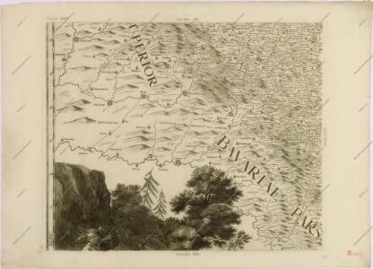
Bairische Landtafeln XXIIII. Darinnē das hochlöblich Furstenthumb Obern unnd Nidern Bayrn sambt der Obern Pflaz Erz unnd Stifft Salzburg Eichstet unnd andern mehrern anstossenden Herschafftē]
1 : 145000 Mollova mapová sbírka Apian, Philipp Amman, Jost Apian, Petrus
exhibet Continuationem Partis Palatinatus Super: Regiminis Straubing: et Villam Jmperialem Augusta Tiberii
1 : 150000 Mollova mapová sbírka Buna, Wilhelm C. Broenner, Heinrich Ludwig
Pars II. exhibet continuationem partis palatinatus super: regiminis Straubing: et villam jmperialem Augusta Tiberii
1 Karte : 54 x 52 cm Heinrich Ludwig Broenner
Fischerei-Karte des Radbusa-Gebietes
Radbuza-oblast (Česko) Schubert, Ottokar Deutsche agrarische Druckerei
Taus und Klattau.
from Spezialkarte der osterreichisch-ungarischen Monarchie.
Klentsch.
from Spezialkarte der osterreichisch-ungarischen Monarchie.
Generální mapa okresního hejtmanství Domažlického
1 : 220000 Domažlice-oblast (Česko) Wagner, Jan Eduard F. Kytka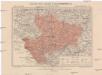
Generální mapa okresního hejtmanství Klatovského
1 : 220000 Klatovy-oblast (Česko) Wagner, Jan Eduard F. Kytka
Podrobná mapa Království českého
1 : 100000 Furth im Wald (Německo) Srp, Jan Jaroslav Bursík
Taus und Klattau
1 : 75000 Domažlice (Česko : oblast) K. u. k. Militärgeographisches Institut
III. vojenské mapování 4249
1 : 75000
Hospodářská mapa revíru Podzámčí
1 : 5835
Podrobná mapa království Českého: Brod n. L.-Sv. Kateřina


Eisenstein und Viechtach
1 : 75000 Železná Ruda (Česko : oblast) Brunner K. u. k. militär-geographisches Institut
Eisenstein und Viechtach
1 : 75000 Železná Ruda (Česko : oblast) K. u. k. Militärgeographisches Institut
Klatovy
1 : 75000 Klatovy-oblast (Česko) Vojenský zeměpisný ústav
Klatovy
1 : 75000 Klatovy (Česko : oblast) Vojenský zeměpisný ústav
III. vojenské mapování 4350
1 : 75000
III. vojenské mapování 4250
1 : 75000
Mapa Šumavy
1 : 50000 Královský Hvozd (Česko) KČST
Kleneč p. Čerchovem
1 : 75000 Klenčí pod Čerchovem-oblast (Česko) Vojenský zeměpisný ústav
Železná Ruda a Viechtach
1 : 75000 Německo Vojenský zeměpisný ústav
Klentsch
1 : 75000 Klenčí pod Čerchovem (Česko : oblast) K. u. k. Militärgeographisches Institut
Klatovy a okolí
1 : 75000 Klatovy (Česko : oblast) Vojenský zeměpisný ústav