Maps of Sudetes Mountains

General-Karte des Königreiches Böhmen...

Koenigreich Boehmen...

[Česko]
Česko
Übersichtskarte der Aerarialstrassen, Eisenbahnen, dann der floss... in Böhmen
Hydrografische Uibersichtskarte der Flüsse, Bäche und sonstigen Gewässer im Königreiche Boehmen
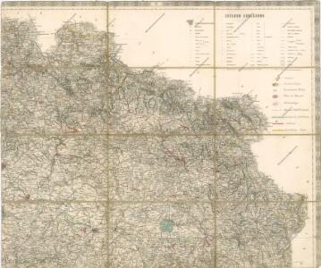
Karte des Bunzlauer- Jičiner- und Königgrätzer Kreises im oestreichischen Kronlande Boehmen
1 : 287000 Hradec Králové-oblast (Česko) Obentraut, Maxmilian Friedrich Kretzschmar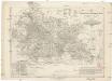
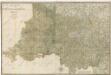
Karte des Bunzlauer- Jičiner- und Königgrätzer Kreises im oestreichischen Kronlande Boehmen
1 : 287000 Hradec Králové-oblast (Česko) Obentraut, Maxmilian Friedrich Kretzschmar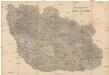
Detail-Operations-Karte für den Krieg in Böhmen 1866
1 : 290000 Česko
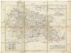
Regni Bohemiae Circuli Biczoviensis et Regionhradecensis...
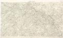
Detail - Karte des nordöstlichen Böhmens

Partie de la Boheme du nord est
Chrudim-oblast (Česko) Kindermann, Joseph Karl Benedict, Ant. im Verlage des Kunst- und Industrie Comptoirs
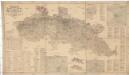
Nordöstlicher Theil von Boehmen enthaltend den Bunzlauer, Bidschower, Königgrätzer, Chrudimer, Czaslauer und Kaurzimer Kreis
1 : 540000 Chrudim-oblast (Česko) Kindermann, Joseph Karl Benedict, Ant. Kunst und Industrie Comptoir
Atlas Bohemiae
Spezial Karte für Verkehr, landwirtschaftliche, Montan u. gewerbliche Industrie des Bezirkes der Handels und Gewerbekammer Reichenberg
1 : 150000 Liberec-oblast (Česko) Daniel, N. N. Daniel
Královehradecká dieceze
1 : 250000
Uebersichts-Karte des Eisenbahnzuges der Süd-Norddeutschen Verbindungsbahn von Pardubitz nach Reichenberg
Liberec (Česko : oblast)
Sect. 20: Görlitz, uit: Geologische Karte des Deutschen Reichs in 27 Blaettern / [von] Richard Lepsius ; Red. von C. Vogel
1 : 500000 Annotatie: Blad 18 ontbreekt; Een aantal bladen op linnen; Een aantal bladen gereviseerd 1913-1914; Annotatie geografische gegevens: Met schaalstokken o.a. in kilometers; Legenda Carl Vogel 1828-1897 Gotha : Justus Perthes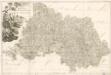
M. Provincia Reginohradecensis et Comitatus Glacensis

Region Královehradecký
1 : 350000
Königgrätz (Schweidnitz)
1 : 300000 Čechy východní (Česko) Hübl Frokr
Region Královehradecký
1 : 350000
Kriegsschauplatz Nordböhmen 1866
1 : 200000 Čechy severní (Česko) K. u. k. militär-geographisches Institut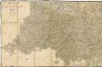
Bidschower und Konigrätzer Kreis...
Bidschower und Konigrätzer Kreis...
[Nordostböhmen]
1 : 750000 Čechy severovýchodní (Česko)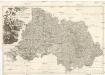
PROVINCIA REGINOHRADECENSIS et COMITATUS GLACENSIS
Hradec Králové-oblast (Česko) Bernardi, Augustin Augustin Bernardi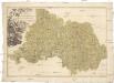
Provincia Reginohradecensis et comitatus Glacensis
Kladsko-oblast (Polsko) Müller, Johann Christoph Winkler
[Dvcatvs Silesiae tabvla altera Svperiorem Silesiam]
Horní Slezsko Hase, Johann Matthias ar les Heritie[rs de Homann
Karte des Sudeten zum Gebrauch für Reisende
1 : 500000 Krkonoše (Česko a Polsko) Schweitzer Gumprecht, A. A. Gumprecht