Maps of Mohácsi járás

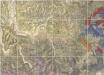
A Dunavölgy Átnézeti Térképe, Carte d ́ensemble del la Vallée du Danube XIX.

Mohacs und Villany.
from Spezialkarte der osterreichisch-ungarischen Monarchie.
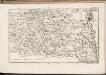
Bataszek und Pecsvarad.
from Spezialkarte der osterreichisch-ungarischen Monarchie.
Mohács
1 : 75000 Mohács
Battaszék
1 : 75000 Komitat Tolna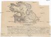
Mohácsiütközet terve
Mohács (Maďarsko)
Bataille de Mohacz
Nouvel atlas physique politique et historique de l'Empire ottoman et des états limitrophes en Europe, en Asie et en Afrique, en quarante feuilles Hellert, J.J. Bellizard, Dufour et Cie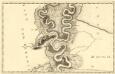
Sectio. IX Mohács - Vrangos
Mollova mapová sbírka Marsili, Luigi Ferdinando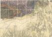
Geologische Karte von Dr. Vadász (Nr. 3, Nr.5)
Geologische Karte von Dr. Vadász (Nr. 3, Nr.5)

Schlacht b. Mohacs 1526
Mohács Schlacht bei Mohács <1526>
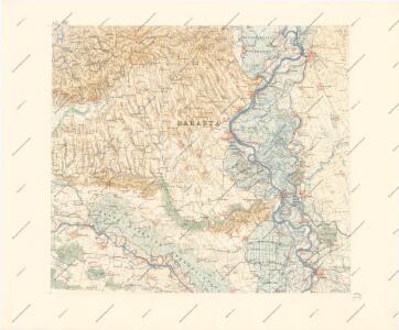
Baranya vármegye térképe
1 : 385000 Baranya (Maďarsko : župa) Kogutowicz, Manó Magyar Földrajzi Intézet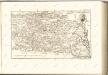
C. Baranyiensis
Ungarn Komitat Baranya
Comitat Baranya
1 : 290000 Baranya (Maďarsko : župa)
Comitat Baranya
1 : 288000 Baranya (Maďarsko : župa)
Mohač - Pečuj
1 : 200000 Pécs (Maďarsko) Kartografska radionica
Zombor.
from Spezialkarte der osterreichisch-ungarischen Monarchie.
Baja.
from Spezialkarte der osterreichisch-ungarischen Monarchie.
Funfkirchen.
from Spezialkarte der osterreichisch-ungarischen Monarchie.
Osijek
1 : 75000 Osijek (Kroatien)
Zombor
1 : 75000 Sombor, Wojwodina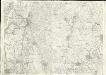
Baja
1 : 75000 Baja
Esseg, Darda und Valpovo.; Spezialkarte der osterreichisch-ungarischen Monarchie.
from Spezialkarte der osterreichisch-ungarischen Monarchie. Austro-Hungarian Monarchy. Militärgeographisches Institut.,
Harkany und Miholjac-Dolnji.; Spezialkarte der osterreichisch-ungarischen Monarchie.
from Spezialkarte der osterreichisch-ungarischen Monarchie. Austro-Hungarian Monarchy. Militärgeographisches Institut.,
Harkány
1 : 75000 Harkány
Fünfkirchen
1 : 75000 Pécs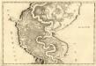
Fulna - Mohacz
Mollova mapová sbírka Marsili, Luigi Ferdinando
Umgebung von Esseg
1 : 75000 Osijek (Chorvatsko) K. u. K. Militärgeographisches Institut