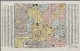
Maps of Halle-Vilvoorde

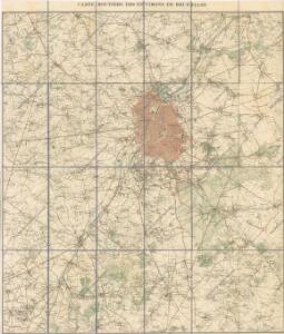
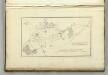
Carte routiere des environs de Bruxelles
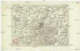
Carte particuliere des environs de Bruxelles et Vilvorden
1 : 163000 Brusel (Belgie) Covens & Mortier
Secvnda Pars Brabantiae cuius urb primaria Brvxellae
1 : 130000 Mollova mapová sbírka Langren, Michael Florent van Bleau, Willem Janszon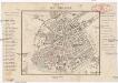
Bruxelles
Brusel (Belgie) Kruse, Friedrich Brügner, C.
Plan parcellaire de la commune de Braine-l'Alleud : avec les mutations
1 : 5000 Royal Library of Belgium Map Room Popp, Philippe Christian (1805-1879) Popp, Philippe Christian (1805-1879)
Plan parcellaire de la ville de Vilvorde : avec les mutations
1 : 5000 Royal Library of Belgium Map Room Popp, Philippe Christian (1805-1879) Popp, Philippe Christian (1805-1879)
Plan parcellaire de la commune de Leeuw-St-Pierre : avec les mutations
1 : 5000 Royal Library of Belgium Map Room Popp, Philippe Christian (1805-1879) Popp, Philippe Christian (1805-1879)
Plan parcellaire de la commune de Tervueren : avec les mutations
1 : 5000 Royal Library of Belgium Map Room Popp, Philippe Christian (1805-1879) Popp, Philippe Christian (1805-1879)
Plan parcellaire de la commune de Grimberghen : avec les mutations
1 : 5000 Royal Library of Belgium Map Room Popp, Philippe Christian (1805-1879) Popp, Philippe Christian (1805-1879)
Plan parcellaire de la commune de Haecht : avec les mutations
1 : 5000 Royal Library of Belgium Map Room Popp, Philippe Christian (1805-1879) Popp, Philippe Christian (1805-1879)
Die Schlacht bei La Belle-Alliance am 18ten Juny 1815
1 : 25000 Brügner, Carl; Brose, Karl Heinrich; Prêtre, Jean Gabriel Prêtre
Plan parcellaire de la commune de Over-Yssche : avec les mutations
1 : 5000 Royal Library of Belgium Map Room Popp, Philippe Christian (1805-1879) Popp, Philippe Christian (1805-1879)
Plan parcellaire de la commune de Rhode-St-Genèse : avec les mutations
1 : 5000 Royal Library of Belgium Map Room Popp, Philippe Christian (1805-1879) Popp, Philippe Christian (1805-1879)
Carte de Belgique au 20.000e / Institut Cartographique Militaire = Kaart van België op een 20.000e
1 : 20000 titelvariant: Kaart van België op een 20.000e; Annotatie: Titel afkomstig van legenda; Gedeeltelijk in zwart-wit of bruindrukuitvoering; Incompleet; Voor aanwezige bladen zie overzichtsblad Institut Cartographique Militaire, Brussel Bruxelles : Institut Cartographique Militaire
Plan parcellaire de la commune de Meysse : avec les mutations
1 : 5000 Royal Library of Belgium Map Room Popp, Philippe Christian (1805-1879) Popp, Philippe Christian (1805-1879)
Plan parcellaire de la commune de Uccle : avec les mutations
1 : 5000 Royal Library of Belgium Map Room Popp, Philippe Christian (1805-1879) Popp, Philippe Christian (1805-1879)
Plan parcellaire de la commune de Wolverthem : avec les mutations
1 : 5000 Royal Library of Belgium Map Room Popp, Philippe Christian (1805-1879) Popp, Philippe Christian (1805-1879)
Plan parcellaire de la commune de Merchtem : avec les mutations
1 : 5000 Royal Library of Belgium Map Room Popp, Philippe Christian (1805-1879) Popp, Philippe Christian (1805-1879)
[Kaart], uit: Plan de Bruxelles et faubourgs
1 : 12500 titelvariant: Bruxelles et ses faubourgs; Annotatie: Omslagtitel: Bruxelles et ses faubourgs Bruxelles : A. de Boeck
Plan parcellaire de la commune de Anderlecht : avec les mutations
1 : 5000 Royal Library of Belgium Map Room Popp, Philippe Christian (1805-1879) Popp, Philippe Christian (1805-1879)
Plan parcellaire de la commune de Watermael-Boitsfort : avec les mutations
1 : 5000 Royal Library of Belgium Map Room Popp, Philippe Christian (1805-1879) Popp, Philippe Christian (1805-1879)
Plan parcellaire de la commune de Brusseghem : avec les mutations
1 : 5000 Royal Library of Belgium Map Room Popp, Philippe Christian (1805-1879) Popp, Philippe Christian (1805-1879)
Plan parcellaire de la commune de Hoeylaert : avec les mutations
1 : 5000 Royal Library of Belgium Map Room Popp, Philippe Christian (1805-1879) Popp, Philippe Christian (1805-1879)
Plan parcellaire de la commune de Ohain : avec les mutations
1 : 5000 Royal Library of Belgium Map Room Popp, Philippe Christian (1805-1879) Popp, Philippe Christian (1805-1879)
Bataille de Mont Saint Jean.
1 : 60000 Melish, John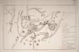
Plan der glorreichen Schlacht bey La belle Alliance am 18ten Juny 1815
Umpfenbach, Johann Wilmans
Plan der glorreichen Schlacht bei La Belle Alliance am 18ten Juni 1815
Waterloo (Belgie) Industrie Comtpoirs
Plan parcellaire de la commune de Assche : avec les mutations
1 : 5000 Royal Library of Belgium Map Room Popp, Philippe Christian (1805-1879) Popp, Philippe Christian (1805-1879)