Maps of Aberdeen
Deeside, Sheet 17 - Bartholomew's "Half Inch to the Mile Maps" of Scotland
1 : 126720 Topographic maps John Bartholomew & Son, Ltd John Bartholomew & Son, Ltd
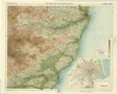
Aberdeen & Deeside, Sheet 17 - Bartholomew's "Half Inch to the Mile Maps" of Scotland
1 : 126720 Topographic maps Bartholomew, John George John Bartholomew & Co
The Sea coast from Fiffnesse to Montros / was Survey'd by Mr. Mar, an injenious Marriner [sic] of Dundee. Sea coast from Fife Ness to Montrose.
Marr, John, fl. 1660-1720 Collins, Greenvile, fl. 1669-1698
The coast of Scotland from the Red-head to Aberdeen. Survey'd by John Adair.
Adair, John, ca. 1650-1722
Aberdeen, Banff 4 S.
1 : 95000 Thomson, John
Stonehaven - OS One-Inch Map
1 : 63360 Topographic maps Ordnance Survey Ordnance Survey
Aberdeen - Bartholomew's 'Survey Atlas of Scotland'
1 : 126720 Topographic maps John Bartholomew & Son, Ltd John Bartholomew & Son, Ltd
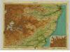
Kincardine Shire.
Thomson, John, 1777- ca. 1840 Johnson, William, fl. 1806-1840
A Map of Kincardineshire.
Garden, William, fl. 1771-1806
Stonehaven & Brechin (51) - OS One-Inch map
1 : 63360 Topographic maps Ordnance Survey Ordnance Survey
Stonehaven & Brechin (51) - OS One-Inch map
1 : 63360 Topographic maps Ordnance Survey Ordnance Survey
Ballater - OS One-Inch Map
1 : 63360 Topographic maps Ordnance Survey Ordnance Survey
Banchory - OS One-Inch map
1 : 63360 Topographic maps Ordnance Survey Ordnance Survey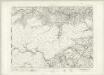
Banchory - OS One-Inch map
1 : 63360 Topographic maps Ordnance Survey Ordnance Survey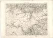
Banchory - OS One-Inch map
1 : 63360 Topographic maps Ordnance Survey Ordnance Survey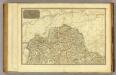
Angusshire N.
1 : 100000 Thomson, John
Aberdeen (45) - OS One-Inch map
1 : 63360 Topographic maps Ordnance Survey Ordnance Survey
Aberdeen (45) - OS One-Inch map
1 : 63360 Topographic maps Ordnance Survey Ordnance Survey
Volume 2: Sheet 67 - Stonehaven
1 : 63360 Farquharson, J.
Stonehaven - OS One-Inch map
1 : 63360 Topographic maps Ordnance Survey Ordnance Survey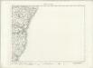
Stonehaven - OS One-Inch map
1 : 63360 Topographic maps Ordnance Survey Ordnance Survey
Stonehaven - OS One-Inch map
1 : 63360 Topographic maps Ordnance Survey Ordnance Survey
Forfar - OS One-Inch map
1 : 63360 Topographic maps Ordnance Survey Ordnance Survey
Forfar - OS One-Inch map
1 : 63360 Topographic maps Ordnance Survey Ordnance Survey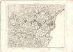
Forfar - OS One-Inch map
1 : 63360 Topographic maps Ordnance Survey Ordnance Survey
Glen Clova & Lochnagar (50) - OS One-Inch map
1 : 63360 Topographic maps Ordnance Survey Ordnance Survey
Glen Clova & Lochnagar (50) - OS One-Inch map
1 : 63360 Topographic maps Ordnance Survey Ordnance Survey
NJ50 - OS 1:25,000 Provisional Series Map
1 : 25000 Topographic maps Ordnance Survey Ordnance Survey
NO59 - OS 1:25,000 Provisional Series Map
1 : 25000 Topographic maps Ordnance Survey Ordnance Survey