Maps of Newham
London VIII.NE - OS Six-Inch Map
1 : 10560 Topographic maps Ordnance Survey Ordnance Survey
Essex (1st Ed/Rev 1862-96) LXXIV.9 (includes: Barking) - 25 Inch Map
1 : 2500 Topographic maps Ordnance Survey Ordnance Survey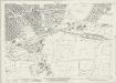
Essex (New Series 1913-) n LXXXVI.8 (includes: Barking) - 25 Inch Map
1 : 2500 Topographic maps Ordnance Survey Ordnance Survey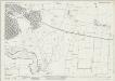
Essex (New Series 1913-) n LXXXVI.8 (includes: Barking) - 25 Inch Map
1 : 2500 Topographic maps Ordnance Survey Ordnance Survey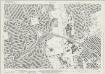
Essex (New Series 1913-) n LXXXVI.3 (includes: Barking; East Ham; Ilford) - 25 Inch Map
1 : 2500 Topographic maps Ordnance Survey Ordnance Survey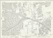
Essex (New Series 1913-) n LXXXVI.3 (includes: Barking; East Ham; Ilford) - 25 Inch Map
1 : 2500 Topographic maps Ordnance Survey Ordnance Survey
London (Edition of 1894-96) XLIV (includes: Barking; East Ham; Ilford) - 25 Inch Map
1 : 2500 Topographic maps Ordnance Survey Ordnance Survey
Essex (New Series 1913-) n LXXXVI.7 (includes: Barking; East Ham) - 25 Inch Map
1 : 2500 Topographic maps Ordnance Survey Ordnance Survey
Essex (New Series 1913-) n LXXXVI.4 (includes: Barking; Ilford) - 25 Inch Map
1 : 2500 Topographic maps Ordnance Survey Ordnance Survey
Essex (New Series 1913-) n LXXXVI.4 (includes: Barking; Ilford) - 25 Inch Map
1 : 2500 Topographic maps Ordnance Survey Ordnance Survey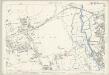
Essex (1st Ed/Rev 1862-96) LXXIII.12 (includes: Barking; East Ham) - 25 Inch Map
1 : 2500 Topographic maps Ordnance Survey Ordnance Survey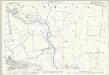
Essex (1st Ed/Rev 1862-96) LXXIV.13 (includes: Barking; Borough Of Woolwich) - 25 Inch Map
1 : 2500 Topographic maps Ordnance Survey Ordnance Survey
London VIII.6 - OS London Town Plan
1 : 1056 Topographic maps Ordnance Survey Ordnance Survey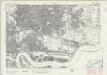
London Sheet L - OS Six-Inch Map
1 : 10560 Topographic maps Ordnance Survey Ordnance Survey
London Sheet L - OS Six-Inch Map
1 : 10560 Topographic maps Ordnance Survey Ordnance Survey
Essex LXXIV.SW - OS Six-Inch Map
1 : 10560 Topographic maps Ordnance Survey Ordnance Survey
Essex LXXIII.SE - OS Six-Inch Map
1 : 10560 Topographic maps Ordnance Survey Ordnance Survey
Essex (1st Ed/Rev 1862-96) LXXIII.16 (includes: Barking; East Ham) - 25 Inch Map
1 : 2500 Topographic maps Ordnance Survey Ordnance Survey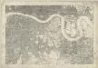
Kent I - OS Six-Inch Map
1 : 10560 Topographic maps Ordnance Survey Ordnance Survey
TQ48 - OS 1:25,000 Provisional Series Map
1 : 25000 Topographic maps Ordnance Survey Ordnance Survey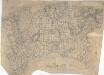
Dagenham
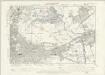
1 : 21120 This rough field sketch, or 'foul' copy, was produced on several pieces of irregularly cut paper joined together and laid on the verso of the triangulation map for southern England. Covering the north side of the Thames, East Ham and Ilford are to the left, and Rainham to the right. The drawing is dominated by a patchwork of field boundaries, with open dotting indicating unproductive enclosed land. The detail recorded here was incorporated in the 'fair' map OSD 132, titled 'Barking'.
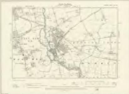
Barking, Essex
1 : 21120 This plan of the north side of the Thames shows Barking and Ilford to the left, on the banks of the Roding, and Rainhham and Hornchurch to the right. A patchwork of field boundaries dominate the landscape, with open dotting depicting unproductive enclosed land. Pencil lines intersect across the plan, recording the angular measurements taken by the surveyor to calculate the distances between fixed points in the landscape.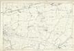
Essex LXXIV - OS Six-Inch Map
1 : 10560 Topographic maps Ordnance Survey Ordnance Survey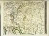
An exact survey of the city's of London Westminster , III
1 Blatt : 53 x 71 cm John Rocque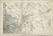
Essex LXXIII - OS Six-Inch Map
1 : 10560 Topographic maps Ordnance Survey Ordnance Survey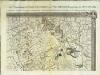
An exact survey of the city's of London Westminster , IV
1 Blatt : 53 x 71 cm John Rocque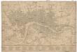
Bowles's new pocket plan of the cities of London and Westminster, with the borough of Southwark
Londýn (Anglie) Herzberg Bowles, Carington Carington Bowles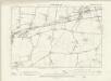
Essex LXXIV.NW - OS Six-Inch Map
1 : 10560 Topographic maps Ordnance Survey Ordnance Survey
Insurance Plan of London East District Vol. G: sheet E
1 : 7200 This detailed 1900 plan of London is one of a series of thirty-five sheets in an atlas originally produced to aid insurance companies in assessing fire risks. The building footprints, their use (commercial, residential, educational, etc.), the number of floors and the height of the building, as well as construction materials (and thus risk of burning) and special fire hazards (chemicals, kilns, ovens) were documented in order to estimate premiums. Names of individual businesses, property lines, and addresses were also often recorded. Together these maps provide a rich historical shapshot of the commercial activity and urban landscape of towns and cities at the time. The British Library holds a comprehensive collection of fire insurance plans produced by the London-based firm Charles E. Goad Ltd. dating back to 1885. These plans were made for most important towns and cities of the British Isles at the scales of 1:480 (1 inch to 40 feet), as well as many foreign towns at 1:600 (1 inch to 50 feet). Chas E Goad Limited Chas E Goad Limited