Maps of Ashford

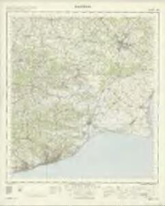
Hastings - OS One-Inch Map
1 : 63360 Topographic maps Ordnance Survey Ordnance Survey
The description of Romney Marsh, Walland, Marshy, Denge and Gulforde marsh, with the divisions of their waterings, heads, armes, principal sewers and their gutts
This is a map of the Romney Marsh area, dating from around 1590. It shows the network of sewers and waterways in the area and is principally concerned with drainage. The locations of bridges are carefully recorded. The topography of the landscape is depicted with hills, trees, churches, towns, villages and windmills shown pictorially. A small island in the sea records the location where a village once stood. Camber castle is shown and the draughtsman has attempted to indicate the actual architectural features of the castle.
A Chart of Rye Harbour, the Island of Oxney, and the Adjacent Country
This is a map of Rye Harbour and the Isle of Oxney, dating from around 1600. Positioned on the estuary of the River Rother, Rye affords a clear view of the Romney Marches, making it a valuable post for coastal defence. Places are represented by elevation views of buildings. The concern with coastal defence at this date was due to England’s continuing war with Spain. Although the Spanish Armada was defeated in 1588 Philip II attempted further invasions during the 1590’s. A scale bar showing ‘myles and furlonges’ is included. The practical use of this map is hinted at by the differentiation in the presentation of domestic townscape views, shown in pictorial elevation, and the plan form that represents Camber Castle, a defensive military structure. A scale bar showing ‘myles and furlonges’ is included.
Tenterden (Hills) - OS One-Inch Revised New Series
1 : 63360 Topographic maps Ordnance Survey Ordnance Survey
Tenterden (Outline) - OS One-Inch Revised New Series
1 : 63360 Topographic maps Ordnance Survey Ordnance Survey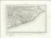
Hastings (Outline) - OS One-Inch Revised New Series
1 : 63360 Topographic maps Ordnance Survey Ordnance Survey
Hastings (Hills) - OS One-Inch Revised New Series
1 : 63360 Topographic maps Ordnance Survey Ordnance Survey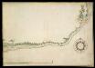
Survey of the Sussex Coast, from Barnham Mille to Rye
This is part of a survey of the Sussex coast made by Sir Thomas Palmer Knight and Walter Coverte and records the section of the coast from Barnham Mille to Rye. Sir Thomas Palmer Knight and Walter Coverte were Deputy Lieutenants of Sussex and its coast line. This survey was made in the reign of Queen Elizabeth, in the year 1578 and is endorsed almost certainly by Nicholas Reynolds 1587. It contains five coloured maps of the coast and inland places of Sussex from Thorney and Selsey Bill to Winchelsea and Camber Castle. Details include compass roses and scale bars in colour. It includes a scale bar showing 'Englishe Myles': 6 miles = 190mm, equating to approximately 1:50688 miles. This survey by Palmer and Covert was commissioned in order to build up defences against the Spanish Armada. Since the accession of the Protestant Elizabeth I the Anglo-Spanish relaionship had deteriorated. Raids on transatlantic shipping by English seamen such as Francis Drake and England’s support of the Protestant rebellion in the Spanish ruled Netherlands inflamed matters further and the Catholic Philip II was induced to invade. The survey is drawn in ink and colour washes on vellum, and features descriptions of coastal locations. The concern with defence is apparent here as the draughtsman has included the beacon network of the area. Windmills in the area are also noted. Due to their height these could also be used as vantage points. Locations of battery's or arsenal stores are recorded by a group of three triangles. Camber Castle is also shown. This was one of the defences built to defend the coast after Francis I of France and Charles V, Holy Roman Emperor and King of Spain signed a peace treaty in 1538, making an invasion of England by their combined forces probable. Information is recorded in a secretary hand with the title and place names in italic. Palmer, Sir Thomas, Coverte, Walter and Reynolds, Nicholas
Hastings 8
1 : 31680 Produced against the background of the Napoleonic Wars, these Ordnance Survey drawings exhibit a hightened interest in defence, particularly along the vulnerable south coast. Military barracks are recorded at Hastings, 'Bopeep' and Bexhill. A faded aquamarine wash defines the coastline from Pevensey Bay to Hastings, with red circles indicating observation stations used to plot the distinctive features of the land being surveyed. Inland, agricultural land (delineated by field boundaries) and woodland dominate the landscape.
A topographical-map, of the county of Kent, 18
1 Blatt : 54 x 71 cm A. Dury, W. Herbert
A topographical-map, of the county of Kent, 23
1 Blatt : 54 x 71 cm A. Dury, W. Herbert
Hythe (Kent)
Drawing of the area in Kent to the west of Hythe and south of Ashford. The drawing is quite worn, making it hard to read. The Hythe coastline is indicated by a blue line. Romney Marsh is shown as a patchwork of green fields. The layout of an orchard at Westernhanger is represented by tiny drawings of individual trees. Detail such as this reveals the meticulousness of the Ordnance Survey.Near Ruckinge, a dot and pencil line are annotated "Military Canal". The Royal Military Canal was built in 1806, stretching for 28 miles from Hythe to Cliff End. It was built as a third line of defence against Napoleon, in combination with the Royal Navy patrol of the English Channel and the line of 74 Martello Towers along the south coast. The pencil line on this drawing, leading from Ruckinge across Romney Marsh to the coast, does not correspond to the actual position of the finished canal. The project had to wait five years after the drawing was produced before the government granted final approval.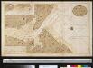
Afteekening van de rivier Rije Camber met alle desselfs dieptens en merken int Canaal even binnen de Hoofden
England Gerard van Keulen
Rye (Sussex)
This plan of the Sussex coast from Fairlight to Rye Bay is made up of two separate sheets of paper joined together, with detail extending over the joins. It was drawn on rectangular sheet lines and is enclosed by a black border. Fields are coloured brown where cultivated, and green or black where untilled. Stone structures are coloured red, something particularly noticeable in the depiction of buildings in the major settlements of Winchelsea and Rye. Produced against the background of the Napoleonic Wars, the drawings exhibit the concern with defence, particularly along the vulnerable south coast. A military battery is documented at Pier Head below Rye. This drawing was produced before the digging of the Royal Military Canal was approved by the government.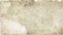
Cranbrook (Kent)
1 : 21120 Drawing showing the area around Cranbrook in Kent. Green washes distinguish cultivated land and woodland from uncultivated land. Relative relief is indicated by shading and brushwork interlining - a technique known as hachuring. One of the notable features of the Ordnance Survey is the attention paid to accurately recording relief, an important issue in planning military campaigns.
Dungeness (Kent)
1 : 31680 This plan of the Dungeness promontory in Kent is drawn on rectangular sheet lines and enclosed by a black border. Fields are coloured brown where cultivated, and green or blank if untilled. Stonework buildings or structures are drawn in red ink at major settlements like Lydd and New Romney. Produced against the background of the Napoleonic Wars, the drawing exhibits the concern with defence, particularly along the vulnerable coastal stretch. Numerous military batteries are documented at Abnor and along the coastline towards Romney Sands.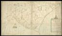
The plat of Romney Marsh, Describing as well the Common Watercourses, with Their Heads, Armes, Pinocks, Bridges, and Principal Gutt
This is a plan of Romney marsh, north of the Rhee Wall dating from around 1592. also describing the common watercourses with their heads, armes, pinocks, bridges and principall gutt, also the high (can't read) and lanes within the same shewing likewise thee true places of the parish churches, dwelling-hou. It shows the communication routes of high ways and lanes and the location of parish churches. Common watercourses are indicated, along with the location of their heads. Romney marsh is one of the largest areas of coastal marshland in England. Due to its nature as wet land adequate drainage of the area is a consideration, reflected by the attention given to water courses here. This map is a derivative of a drainage map attributed to Thomas Langdon.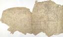
Chilham, Kent 17
This drawing comprises several sheets of paper joined together. Although roads and field boundaries are shown, much other detail is missing from the drawing and no indication of relief is indicated. Major settlements are named and individual buildings are delineated in red or black, indicating stone or wood structures. A pencil note in the bottom right corner records the publication date and status of the drawing as a proof.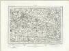
Maidstone (Outline) - OS One-Inch Revised New Series
1 : 63360 Topographic maps Ordnance Survey Ordnance Survey
Maidstone (Hills) - OS One-Inch Revised New Series
1 : 63360 Topographic maps Ordnance Survey Ordnance Survey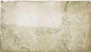
Charing, Kent(002OSD000000017U00375000)
The dominant feature of this drawing is the use of different shades of green to distinguish fields and woods. The draughtsman has depicted individual trees and recorded the position of clearings in Chilham Park. Such detail is testimony to the meticulousness of the Survey. The Stone Street Causeway, a Roman road, is shown to the left of the plan. Connecting Lympne to Canterbury, it is likely to have been the route taken by Henry II's men on their way to murder Archbishop Thomas Becket in Canterbury Cathedral on 29 December 1170.
Dunge Ness (Outline) - OS One-Inch Revised New Series
1 : 63360 Topographic maps Ordnance Survey Ordnance Survey
Folkestone (Hills) - OS One-Inch Revised New Series
1 : 63360 Topographic maps Ordnance Survey Ordnance Survey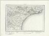
Folkestone (Outline) - OS One-Inch Revised New Series
1 : 63360 Topographic maps Ordnance Survey Ordnance Survey
A topographical-map, of the county of Kent, 13
1 Blatt : 54 x 71 cm A. Dury, W. Herbert
A topographical-map, of the county of Kent, No. 24
1 Blatt : 54 x 71 cm A. Dury, W. Herbert
A topographical-map, of the county of Kent, 17
1 Blatt : 54 x 71 cm A. Dury, W. Herbert
Charing, Kent(002OSD000000017U00376000)
This rough sketch was produced in the field. Crosshatching indicates relief and generalised representations of treetops describe woodland.
Fairlight (East Sussex)
1 : 21120 This outline plan in black and white ink follows the East Sussex coastline from Fairlight, at the bottom, to Beckley and Northiam, at the top. Such drawings represent the halfway point between the original protraction and the 'fair copy', and give no indication of relative relief. Triangles ruled in red ink cover the map, revealing the angular measurements taken to plot the location of individual topographical features.