Maps of West Sussex

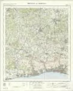
Brighton and Worthing - OS One-Inch Map
1 : 63360 Topographic maps Ordnance Survey Ordnance Survey
London passenger transport map
Ordnance Survey
Guildford
1 : 63360 Ordnance Survey Office
Guildford
1 : 63360 Ordnance Survey Office
Guildford
1 : 63360 Ordnance Survey Office
West Grinstead
1 : 31680 The ochre-coloured Roman road, Stane Street, runs from Pulborough at the bottom left of the map to Rudgwick at the top right. Windmills proliferate throughout the area and are represented in elevation. The physical condition of the plan is poor and place names are difficult to read because the manuscript is dirty, worn and ripped. Budgen, Thomas
Brighton (Hills) - OS One-Inch Revised New Series
1 : 63360 Topographic maps Ordnance Survey Ordnance Survey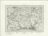
Brighton (Outline) - OS One-Inch Revised New Series
1 : 63360 Topographic maps Ordnance Survey Ordnance Survey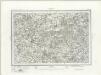
Horsham (Outline) - OS One-Inch Revised New Series
1 : 63360 Topographic maps Ordnance Survey Ordnance Survey
Horsham (Hills) - OS One-Inch Revised New Series
1 : 63360 Topographic maps Ordnance Survey Ordnance Survey
Steyning
1 : 31680 This plan presents a seciton of the South Downs coastline from Littlehampton at the bottom left to Old Shoreham at bottom right. The meandering River Arun forms the left-hand boundary. Produced against the background of the Napoleonic Wars, the drawing shows the vulnerable south coast heavily defended against invasion. Barracks are noted at Littlehampton, near Arundel Bridge and Steyning. The draughtsman has recorded the iron-age hill fort at Cissbury Ring and the foundations of a Roman-British temple at Chanctonbury Ring, even though the documentation of archaeological details did not become obligatory until 1816. Budgen, Thomas
Cranleigh
1 : 31680 Turnpike roads, shown in faded yellow ochre, run from Guildford at the top of the map to Witley in the centre left and "Aldfold" in the bottom left. Black-ink figures record the mileage along these routes. Tollgates are marked "TG". A dotted symbol depicts the untilled agricultural land that dominate the landscape around the valley of the River Wye, from Guildford to Godalming. The stippling technique commonly used to depict rough pasture is used here for the many heaths and commons of the undulating Surrey lowlands. Budgen, Thomas
Cuckfield 16
1 : 21120 This drawing is in very poor condition and difficult to interpret. Field boundaries are recorded. Relief is indicated by cross-hatching and shading, with the summits of inclines left bare, to give an impression of the undulating landscape.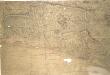
Lewes
1 : 31680 .This plan of the South Downs coastline runs from Kingston by Sea at the bottom left to Telscombe at the bottom right., The,vulnerable south coast was heavily defended against invasion., Barracks are recorded at New Shoreham and Lewes, with a series of batteries at Brighthelmston., The draughtsman also documented Anglo-Saxon defensive mounds at Poor Man's Wall and the Devil's Dyke, even though the recording of archaeological details did not become obligatory until 1816. Budgen, Thomas
Ditchling
1 : 31680 This plan of the Sussex Weald shows Cowfold and Henfield to the left, with Fetching and Newick to the right. The map is in very poor condition and difficult to read. Field boundaries are recorded, with disconnected pencil strokes indicating relief ('hachures') only faintly discernible. Budgen, Thomas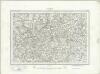
Haslemere (Outline) - OS One-Inch Revised New Series
1 : 63360 Topographic maps Ordnance Survey Ordnance Survey
Haslemere (Hills) - OS One-Inch Revised New Series
1 : 63360 Topographic maps Ordnance Survey Ordnance Survey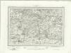
Chichester (Outline) - OS One-Inch Revised New Series
1 : 63360 Topographic maps Ordnance Survey Ordnance Survey
Chichester (Hills) - OS One-Inch Revised New Series
1 : 63360 Topographic maps Ordnance Survey Ordnance Survey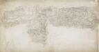
East Grinstead 19
1 : 31680 A blue watercolour wash has been used here to describe relief, with the summits of hills left bare. Dense forestation in the area is indicated by rashes of small trees. Main communication routes are coloured buff-yellow, conforming to military cartographic convention. A red pecked line describes the county boundary.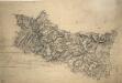
Chiddingfold
1 : 31680 .A turnpike road, coloured ochre yellow, forms a boundary from Hascombe at the top right of the map to 'Aldfold' at the bottom. Common land and dense woodland dominate the region to the left around Hindhead Valley and the Devil's Punchbowl.Commonland is indicated by open dotting. Woods and trees could provide hindrance or cover for the movement of a regiment, so these are recorded in painstaking detail. Individual trees are depicted with a small vertical stem and a shadow at the base. There are also more general representations of groups of treetops. Budgen, Thomas
Worthing (Outline) - OS One-Inch Revised New Series
1 : 63360 Topographic maps Ordnance Survey Ordnance Survey
Worthing (Hills) - OS One-Inch Revised New Series
1 : 63360 Topographic maps Ordnance Survey Ordnance Survey
Ockley
1 : 31680 The plan of this undulating lowland region of Surrey is intersected by the Stane Street Causeway. At the top right of the plan is the Anstiebury Camp hillfort. This ancient site is denoted by a large circle and a cross, although the recording of archaeological details did not become obligatory until 1816. Clusters of treetops dominate the map, which also illustrates several windmills. Budgen, Thomas
TQ24 - OS 1:25,000 Provisional Series Map
1 : 25000 Topographic maps Ordnance Survey Ordnance Survey
TQ23 - OS 1:25,000 Provisional Series Map
1 : 25000 Topographic maps Ordnance Survey Ordnance Survey
TQ22 - OS 1:25,000 Provisional Series Map
1 : 25000 Topographic maps Ordnance Survey Ordnance Survey
TQ14 - OS 1:25,000 Provisional Series Map
1 : 25000 Topographic maps Ordnance Survey Ordnance Survey
TQ21 - OS 1:25,000 Provisional Series Map
1 : 25000 Topographic maps Ordnance Survey Ordnance Survey