Maps of Surrey

London SW - OS One-Inch Map
1 : 63360 Topographic maps Ordnance Survey Ordnance Survey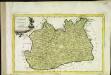
Provincia di Surrey
1 Karte : Kupferdruck ; 18 x 29 cm Zatta presso Antonio Zatta
An accurate map of the county of Surrey
1 Karte : Kupferdruck ; 51 x 69 cm Bowen; Hinton sold by I. Hinton at the Kings Arms in St Pauls Church Yard
Svrria vernacule Svrrey
1 Karte : Kupferdruck ; 36 x 48 cm Blaeu Joan Blaeu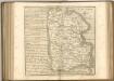
Hampton Court 20
1 : 31680 This drawing of London and the surrounding Thames countryside provides a fascinating blueprint of Regency London. The layouts of the ornamental gardens and tree-lined avenues of Hampton Court and nearby Bushy Park are shown in detail. These contrast with the depiction of Kew Gardens, which is left blank within its boundaries. The Ordnance Survey Letter Book records: "When the Ordnance Survey of the vicinity of Brentford was made, The Surveyor was not permitted to enter Kew Gardens." At that time, King George III was recuperating at Kew from bouts of mental illness: the king's privacy and security took primacy over mapmaking. Stanley, William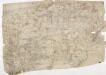
Detail from OSD 127 (Hampton Court), showing Kingston, Richmond and Twickenham
This drawing of London and the surrounding Thames countryside provides a fascinating blueprint of Regency London. The layouts of the ornamental gardens and tree-lined avenues of Hampton Court and nearby Bushy Park are shown in detail. These contrast with the depiction of Kew Gardens, which is left blank within its boundaries. The Ordnance Survey Letter Book records: "When the Ordnance Survey of the vicinity of Brentford was made, The Surveyor was not permitted to enter Kew Gardens." At that time, King George III was recuperating at Kew from bouts of mental illness: the king's privacy and security took primacy over mapmaking. Stanley, William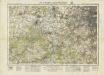
England and Wales [OS of]
Ordnance Survey
London passenger transport map
Ordnance Survey
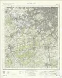
Guildford
1 : 63360 Ordnance Survey Office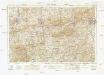
Guildford
1 : 63360 Ordnance Survey Office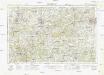
Guildford
1 : 63360 Ordnance Survey Office
Cranleigh
1 : 31680 Turnpike roads, shown in faded yellow ochre, run from Guildford at the top of the map to Witley in the centre left and "Aldfold" in the bottom left. Black-ink figures record the mileage along these routes. Tollgates are marked "TG". A dotted symbol depicts the untilled agricultural land that dominate the landscape around the valley of the River Wye, from Guildford to Godalming. The stippling technique commonly used to depict rough pasture is used here for the many heaths and commons of the undulating Surrey lowlands. Budgen, Thomas
Reigate 2
1 : 31680 A dashed black-ink line runs along the boundary of Surrey and Sussex at the bottom of this plan of the North Downs., The bottom right of the manuscript carries a blue- rubber stamp from the 1950s, indicating that the plan was held in the Ordnance Survey Medium and Small Scales Division. Budgen, Thomas
A new correct map of Middlesex
Warburton, John, Bland, Joseph and Smyth, Payler
London passenger transport map
Ordnance Survey
Reigate (Hills) - OS One-Inch Revised New Series
1 : 63360 Topographic maps Ordnance Survey Ordnance Survey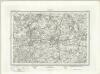
Reigate (Outline) - OS One-Inch Revised New Series
1 : 63360 Topographic maps Ordnance Survey Ordnance Survey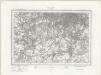
South London (Outline) - OS One-Inch Revised New Series
1 : 63360 Topographic maps Ordnance Survey Ordnance Survey
South London (Hills) - OS One-Inch Revised New Series
1 : 63360 Topographic maps Ordnance Survey Ordnance Survey
Carte topographique de le comté de Middlesex, 3
1 Blatt : 53 x 70 cm John Rocque
The first sheet of an actual survey of Berkshire
1 Blatt : 68 x 52 cm publish'd according to act of parliament by John Rocque chorographer to their royal Highnesses the late and present Prince of Wales etc. in the Strand
MILNE'S PLAN of the CITIES of LONDON and WESTMINSTER, circumjacent TOWNS and PARISHES &c. laid down from a TRIGONOMETRICAL SURVEY taken in the YEARS 1795-1799
This is one of six sheets forming Milne's map of the area twenty miles around London. It was the first to make use of the 'Trygonometrical Survey' founded in 1791. This sheet covers the area to the west and south-west of the capital. It shows all the field boundaries and indicates land use with a complex system of letters and colours. The key is featured on the top corners. The borders of the map are divided in minutes and seconds, giving scale, angles of observations and magnetic variations. Thomas Milne trained as an estate surveyor and worked on the first Ordnance Survey map of Kent. Milne, Thomas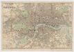
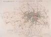
Philip's new plan of London, 1873
1 : 18900 George Philip & Son George Philip & Son
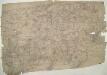
Chobham
1 : 31680 .This map is in poor repair. Its edges are dirty and damaged, and a join is visible where the drawing has been torn. Triangulation points can be seen at the map's boundaries, along with a series of stitch holes. Silk tape was wound through these holes to protect the map in the field. .The drawing details a large number of commons, including Pirbright, Ham Haw and Ockham. These are depicted by patterns of open dotting. Basingstoke Canal also features. It was completed in 1794, only a few years before this map was drawn. Blue washes, used to depict water, have faded. The town of Chertsey appears towards the top right, along with the ruins of Chertsey Abbey. The abbey was founded in AD666, as a house for the Benedictine Order, and dissolved in 1537. Budgen, Thomas
Horsham (Outline) - OS One-Inch Revised New Series
1 : 63360 Topographic maps Ordnance Survey Ordnance Survey
Horsham (Hills) - OS One-Inch Revised New Series
1 : 63360 Topographic maps Ordnance Survey Ordnance Survey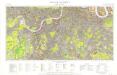
Great Britain [Second land utilisation survey] 1:25,000
Coleman, Alice Isle of Thanet Geographical Association
How to travel in and around London by railway
London : M. Vigers