Maps of Somerset

Minehead - OS One-Inch Map
1 : 63360 Topographic maps Ordnance Survey Ordnance Survey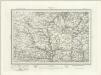
Dulverton (Outline) - OS One-Inch Revised New Series
1 : 63360 Topographic maps Ordnance Survey Ordnance Survey
Dulverton (Hills) - OS One-Inch Revised New Series
1 : 63360 Topographic maps Ordnance Survey Ordnance Survey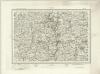
Tiverton (Outline) - OS One-Inch Revised New Series
1 : 63360 Topographic maps Ordnance Survey Ordnance Survey
Tiverton (Hills) - OS One-Inch Revised New Series
1 : 63360 Topographic maps Ordnance Survey Ordnance Survey
Tiverton, Devon
The Ordnance Survey drawings show a greater preoccupation with the lie of the land than earlier maps. Relative relief and natural cover were important considerations in the planning of military strategies. The heavy brushwork interlining ('hachuring') on this drawing makes many place names and details difficult to interpret. The Ex River is shown running through the area. Part of the river forms the county boundary between Devon and Somerset, shown here by a red dotted line.
Minehead
Relief is depicted in this drawing by short lines ('hachures') rendered in blue-grey watercolour. The boundary between cartography and landscape painting is bridged somewhat in drawings such as this. Many of the drawing instructors for the Ordnance Survey were accomplished artists. Main communication routes are coloured yellow and marked at intervals of one mile.
Dunster
A section of the English south coast from Dunster to Watchet is covered by this drawing. Sand is indicated by a speckled grey wash, with grey shapes signifying rocks. Although it was not compulsory to include archaeological sites at the time of this map's survey, the draughtsman has noted an iron age settlement near Wiviliscombe as an 'Ancient Camp'. Several quarries are also marked,including a slate quarry at Oakhampton Wood.
Cullompton
The heavy colour washes used to depict relief make this plan difficult to interpret. These Ordnance Survey drawings show a greater preoccupation with the lie of the land than any previous maps - testimony to the military impetus of the project. Inclines are indicated by interlining ('hachuring'), with the summits left bare. The boundary of Devon and Somerset is shown by a red pecked line. A note in the margin of the paper provides a key to the plan's interpretation.
Minehead (Hills) - OS One-Inch Revised New Series
1 : 63360 Topographic maps Ordnance Survey Ordnance Survey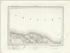
Minehead (Outline) - OS One-Inch Revised New Series
1 : 63360 Topographic maps Ordnance Survey Ordnance Survey
Milverton
This drawing covers the boundary between Devon and Somerset. A red pecked line running across the Black Down Hills indicates the border. Dark brushwork interlining ('hachuring') describes relief, making certain place names and details hard to distinguish. Settlements are indicated by red blocks. The draughtsman has drawn individual trees in gardens and orchards. The sandbanks of the River Culm are described by dots. Major communication routes are tinted yellow, following military cartographic practice. Those crossing uncultivated land are drawn with a pecked line.
Lydiard St. Laurence
1 : 21120 This drawing covers part of Somerset. The narrow ridge of the Quantock Hills, depicted on the left by brushwork interlining, runs north west from Taunton Deane Vale for 19km to the Bristol Channel coast. At the top of the sheet, white rocks are indicated along the coastline of Bridgewater Bay. Woodland, heathland, formal parkland and arable land are distinguished by symbols.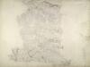
North Molton, Devon
Much of this drawing,is dominated by,the open land of the downs.,Relief is indicated by shading and brushwork interlining ('hachures') but there is no numerical,record of trigonometrical altitudes. Paths on the moor are distinguished from roads by their pecked lines; roads,through villages are indicated by parallel lines. Hewitt, John
Taunton (Hills) - OS One-Inch Revised New Series
1 : 63360 Topographic maps Ordnance Survey Ordnance Survey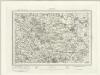
Taunton (Outline) - OS One-Inch Revised New Series
1 : 63360 Topographic maps Ordnance Survey Ordnance Survey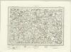
Wellington (Outline) - OS One-Inch Revised New Series
1 : 63360 Topographic maps Ordnance Survey Ordnance Survey
Wellington (Hills) - OS One-Inch Revised New Series
1 : 63360 Topographic maps Ordnance Survey Ordnance Survey
SS84 - OS 1:25,000 Provisional Series Map
1 : 25000 Topographic maps Ordnance Survey Ordnance Survey
SS83 - OS 1:25,000 Provisional Series Map
1 : 25000 Topographic maps Ordnance Survey Ordnance Survey
SS82 - OS 1:25,000 Provisional Series Map
1 : 25000 Topographic maps Ordnance Survey Ordnance Survey
SS94 - OS 1:25,000 Provisional Series Map
1 : 25000 Topographic maps Ordnance Survey Ordnance Survey
SS81 - OS 1:25,000 Provisional Series Map
1 : 25000 Topographic maps Ordnance Survey Ordnance Survey
SS93 - OS 1:25,000 Provisional Series Map
1 : 25000 Topographic maps Ordnance Survey Ordnance Survey
SS92 - OS 1:25,000 Provisional Series Map
1 : 25000 Topographic maps Ordnance Survey Ordnance Survey
ST04 - OS 1:25,000 Provisional Series Map
1 : 25000 Topographic maps Ordnance Survey Ordnance Survey
SS91 - OS 1:25,000 Provisional Series Map
1 : 25000 Topographic maps Ordnance Survey Ordnance Survey
ST03 - OS 1:25,000 Provisional Series Map
1 : 25000 Topographic maps Ordnance Survey Ordnance Survey
ST02 - OS 1:25,000 Provisional Series Map
1 : 25000 Topographic maps Ordnance Survey Ordnance Survey


