Maps of Winkleigh

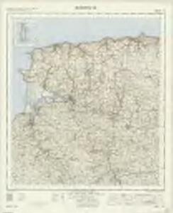
Barnstaple - OS One-Inch Map
1 : 63360 Topographic maps Ordnance Survey Ordnance Survey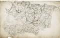
Barnstaple, Devon
The indication of land relief and attention to communication routes on this plan conform to the military and cartographic standards employed by the West Country survey. The south of England was the area most vulnerable to invasion, especially during the Napoleonic conflicts between 1793 and 1815. Accurate mapping of the Devonshire coastline was, therefore, of great military significance. Towards the left of the plan, the sand dunes of Braunton Burrows stretch southwards from the sea at Barnstaple Bay towards Appledore and Bideford.
South Molton, Devon
This relief on this drawing,is indicated by dense interlining ('hachures'), with,the summits of hills left blank. The drawing has been made on three pieces of paper mounted as one sheet., Dirty, worn and creased, the manuscript is difficult to decipher. ,A pencil note at the base of the drawing reads "To survey from * to * as ...by...the Farms as named."
Roborough
Topography and areas of natural shelter were both of great importance in planning,any military campaign., To this end, inclines and woodland are clearly indicated on this drawing., The main communication routes are highlighted in yellow., Some roads have been pin-marked along their lengths, proof that the draughtsman used measuring dividers to plot the exact course of the roads., The dates of draughting and the scale of the drawing have been recorded in pencil on the bottom right of the sheet. Hewitt, John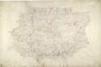
South Molton
1 : 31680 This drawing is delicately shaded and subtly coloured, with yellow-tinted communication routes and red-ink stone buildings. Indistinct triangulation lines, corresponding to focal points of the drawing, appear on the reverse of the manuscript. A rough pencil circle is drawn around South Molton, the largest settlement in the area.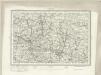
Barnstaple (Outline) - OS One-Inch Revised New Series
1 : 63360 Topographic maps Ordnance Survey Ordnance Survey
Barnstaple (Hills) - OS One-Inch Revised New Series
1 : 63360 Topographic maps Ordnance Survey Ordnance Survey
Chulmleigh (Hills) - OS One-Inch Revised New Series
1 : 63360 Topographic maps Ordnance Survey Ordnance Survey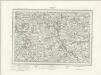
Chulmleigh (Outline) - OS One-Inch Revised New Series
1 : 63360 Topographic maps Ordnance Survey Ordnance Survey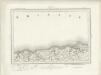
Ilfracombe (Outline) - OS One-Inch Revised New Series
1 : 63360 Topographic maps Ordnance Survey Ordnance Survey
Ilfracombe (Hills) - OS One-Inch Revised New Series
1 : 63360 Topographic maps Ordnance Survey Ordnance Survey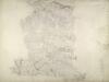
North Molton, Devon
Much of this drawing,is dominated by,the open land of the downs.,Relief is indicated by shading and brushwork interlining ('hachures') but there is no numerical,record of trigonometrical altitudes. Paths on the moor are distinguished from roads by their pecked lines; roads,through villages are indicated by parallel lines. Hewitt, John
SS44 - OS 1:25,000 Provisional Series Map
1 : 25000 Topographic maps Ordnance Survey Ordnance Survey
SS43 - OS 1:25,000 Provisional Series Map
1 : 25000 Topographic maps Ordnance Survey Ordnance Survey
SS42 - OS 1:25,000 Provisional Series Map
1 : 25000 Topographic maps Ordnance Survey Ordnance Survey
SS54 - OS 1:25,000 Provisional Series Map
1 : 25000 Topographic maps Ordnance Survey Ordnance Survey
SS41 - OS 1:25,000 Provisional Series Map
1 : 25000 Topographic maps Ordnance Survey Ordnance Survey
SS53 - OS 1:25,000 Provisional Series Map
1 : 25000 Topographic maps Ordnance Survey Ordnance Survey
SS52 - OS 1:25,000 Provisional Series Map
1 : 25000 Topographic maps Ordnance Survey Ordnance Survey
SS64 - OS 1:25,000 Provisional Series Map
1 : 25000 Topographic maps Ordnance Survey Ordnance Survey
SS51 - OS 1:25,000 Provisional Series Map
1 : 25000 Topographic maps Ordnance Survey Ordnance Survey
SS63 - OS 1:25,000 Provisional Series Map
1 : 25000 Topographic maps Ordnance Survey Ordnance Survey
SS62 - OS 1:25,000 Provisional Series Map
1 : 25000 Topographic maps Ordnance Survey Ordnance Survey
SS74 & Parts of SS75 - OS 1:25,000 Provisional Series Map
1 : 25000 Topographic maps Ordnance Survey Ordnance Survey
SS61 - OS 1:25,000 Provisional Series Map
1 : 25000 Topographic maps Ordnance Survey Ordnance Survey
SS73 - OS 1:25,000 Provisional Series Map
1 : 25000 Topographic maps Ordnance Survey Ordnance Survey
SS72 - OS 1:25,000 Provisional Series Map
1 : 25000 Topographic maps Ordnance Survey Ordnance Survey
SS71 - OS 1:25,000 Provisional Series Map
1 : 25000 Topographic maps Ordnance Survey Ordnance Survey
Somerset XXXII.SW & SE - OS Six-Inch Map
1 : 10560 Topographic maps Ordnance Survey Ordnance Survey