Maps of Bedfordshire

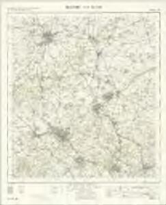
Bedford and Luton - OS One-Inch Map
1 : 63360 Topographic maps Ordnance Survey Ordnance Survey
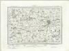
The county of Bedford
1 Karte : Kupferdruck ; 68 x 45 cm Jefferys s.n.
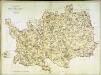
An accurate map of the county of Bedford
1 Karte : Kupferdruck ; 68 x 50 cm Bowen; Hinton sold by I Hinton at the Kings Arms in St. Pauls Church Yard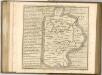
A topographical map of Hartford-Shire
1 Karte : Kupferdruck ; 52 x 70 cm Dury; Andrews Andrew Dury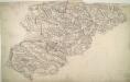
Luton
The boundaries of the counties of Bedfordshire, Buckinghamshire, and Hertfordshire are marked on this plan by pecked red lines. Red dots within circles indicate trigonometrical points from which the surveyor took angular measurements to plot topographical features of the landscape. Hyett, William
Bedfordiensis comitatvs; anglis Bedford Shire
2 Karten auf einem Blatt : Kupferdruck ; Bildgrösse 42 x 53 cm Blaeu Joan Blaeu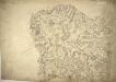
Baldock
1 : 31680 The prehistoric Icknield Way runs from just left of Hitchin at the bottom of this plan to Royston at the top right. Earthworks and Roman roads are described, as is the New Inn near Caldecote. Inns provided important stopping points for food, accommodation, and a change of horse. The River Cam which rises near Ashwell depicted in blue. Hyett, William
Woburn
1 : 31680 This county boundary of Bedfordshire and Buckinghamshire is depicted as a black dotted line at bottom left. Down the right of the sheet, many triangulation points are marked in red ink. Toll roads are highlighted in yellow, with turnpikes indicated along their routes. A section of the Watling Street, between Dunstable and Little Brickhill, is indicated near the bottom of the sheet. This Roman road ran from London to Wroxeter in Wales, via St. Albans. Symbols distinguish different types land use, while shading is used to indicate relief. Hyett, William
London passenger transport map
Ordnance Survey
Hatfield
1 : 31680 This map is not drawn with north at the top. Potters Bar appears at the bottom left, almost on a level with Hertford at the bottom right. The remains of the Old Royal Palace of Hatfield are shown near the centre of the map. This was the home of Elizabeth I (1533-1603) prior to her accession to the throne. Also featured is Hatfield, the house built in 1611 by the first Earl of Salisbury, Robert Cecil (1563-1612). A poorhouse is marked just outside the town. Hyett, William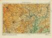
Hertford& St Albans
Ordnance Survey
Hitchin (Hills) - OS One-Inch Revised New Series
1 : 63360 Topographic maps Ordnance Survey Ordnance Survey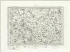
Hitchin (Outline) - OS One-Inch Revised New Series
1 : 63360 Topographic maps Ordnance Survey Ordnance Survey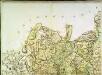
A topographical map of Hartford-Shire, 2
1 Blatt : 53 x 72 cm A. Dury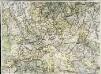
A topographical map of Hartford-Shire, 5
1 Blatt : 53 x 72 cm A. Dury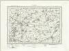
Biggleswade (Outline) - OS One-Inch Revised New Series
1 : 63360 Topographic maps Ordnance Survey Ordnance Survey
Biggleswade (Hills) - OS One-Inch Revised New Series
1 : 63360 Topographic maps Ordnance Survey Ordnance Survey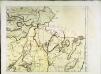
The county of Bedford, 4
1 Blatt : 53 x 72 cm s.n.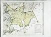
The county of Bedford, 6
1 Blatt : 53 x 72 cm s.n.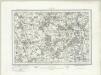
Hertford (Outline) - OS One-Inch Revised New Series
1 : 63360 Topographic maps Ordnance Survey Ordnance Survey
Hertford (Hills) - OS One-Inch Revised New Series
1 : 63360 Topographic maps Ordnance Survey Ordnance Survey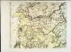
The county of Bedford, 5
1 Blatt : 53 x 72 cm s.n.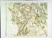
The county of Bedford, 3
1 Blatt : 53 x 72 cm s.n.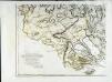
The county of Bedford, 7
1 Blatt : 53 x 72 cm s.n.
Caxton
1 : 31680 .Caxton was a parish along the Ermine Street, the Roman road from Chichester in West Sussex to York via Lincoln. The road forms the western boundary of the plan and is highlighted in buff. To the right of this boundary is the market and parish town of St. Neots, situated on the east bank of the navigable River Ouse. Here, a stone bridge, built in 1588 from the ruins of an old abbey, connects Huntingdonshire with Bedfordshire. Along the River Ouse, about a mile north of St Neots and partly in the parish of Little Paxton, are the premises of the St. Neots Paper Mill Company. Hyett, William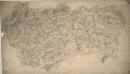
Bedford
1 : 31680 This drawing follows the River Ouse as it meanders through part of Bedfordshire. Flood plains, grazing meadows, hedgerows, ancient woods and water mills are some of the prominent features of the Ouse Valley represented on the map. Hyett, William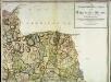
A topographical map of Hartford-Shire, 3
1 Blatt : 53 x 72 cm A. Dury
Bedford (Hills) - OS One-Inch Revised New Series
1 : 63360 Topographic maps Ordnance Survey Ordnance Survey