Maps of Herefordshire

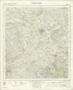
Hereford - OS One-Inch Map
1 : 63360 Topographic maps Ordnance Survey Ordnance Survey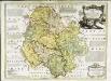
An accurate map of Hereford Shire
1 Karte : Kupferdruck ; 51 x 69 cm Bowen; Tinney sold by I. Tinney at the Golden Lion in Fleet street
Herefordia comitatvs
1 Karte : Kupferdruck ; 39 x 48 cm Blaeu Joan Blaeu
Usk(002OSD000000003U00162000)
1 : 31680 .The Monnow Valley, down the right side of the sheet, forms a natural break in defences along the border of southern Wales.,Depicted along the valley are the Norman,castles of Grosmont, Skenfirth, Tregets and Monmouth, which,once guarded the routes between Herefordshire and Wales. ,Monmouth was of particular importance, lying exactly on the border where the river Monnow joins the Wye. Iron roads, the horse railroads pre-dating the locomotive era, feature at lower right. Highlighted,in ochre, these were probably added,to the plan some time after its official completion. Budgen Charles
Weobly
1 : 31680 The right-hand portion of this manuscript features several annotated red crosses. These represent observation and trigonometrical stations from which angular measurements were been taken. To the far left, red-ink lines describe the Monmouth River, highlighting it as the boundary separating Herefordshire and Monmothshire. The borders of the published sheet can be seen in pencil. Budgen, Thomas
New map of the county of Hereford, 3
1 Blatt : 71 x 58 cm s.n.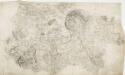
Hereford 22
1 : 31680 Below the city of Hereford, near the top of the sheet, the River Wye flows,through a winding river channel,across a broad floodplain with few major settlements. The floodplain is mostly farmland, dotted by,very small areas of woodland and marsh., The main river banks are lined irregularly with tall alder and willow trees, illustrated on this plan. Budgen, Thomas
New map of the county of Hereford, 4
1 Blatt : 71 x 58 cm s.n.
Hereford (Outline) - OS One-Inch Revised New Series
1 : 63360 Topographic maps Ordnance Survey Ordnance Survey
Hereford (Hills) - OS One-Inch Revised New Series
1 : 63360 Topographic maps Ordnance Survey Ordnance Survey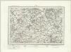
Ross (Outline) - OS One-Inch Revised New Series
1 : 63360 Topographic maps Ordnance Survey Ordnance Survey
Ross (Hills) - OS One-Inch Revised New Series
1 : 63360 Topographic maps Ordnance Survey Ordnance Survey
Monmouth (Hills) - OS One-Inch Revised New Series
1 : 63360 Topographic maps Ordnance Survey Ordnance Survey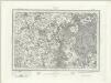
Monmouth (Outline) - OS One-Inch Revised New Series
1 : 63360 Topographic maps Ordnance Survey Ordnance Survey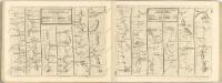

Bromyard
Most of the common land in Hertsfordshire is included in this map, which covers Bromyard Down, Badley Wood, and Bringsty Common. Sutton Walls, an Iron Age hillfort, is north of the River Lugg. Budgen, T.
Bromyard
Most of the common land in Hertsfordshire is included in this map, which covers Bromyard Down, Badley Wood, and Bringsty Common. Sutton Walls, an Iron Age hillfort, is north of the River Lugg. Budgen, T.
SO35 - OS 1:25,000 Provisional Series Map
1 : 25000 Topographic maps Ordnance Survey Ordnance Survey
SO34 - OS 1:25,000 Provisional Series Map
1 : 25000 Topographic maps Ordnance Survey Ordnance Survey
SO33 - OS 1:25,000 Provisional Series Map
1 : 25000 Topographic maps Ordnance Survey Ordnance Survey
SO45 - OS 1:25,000 Provisional Series Map
1 : 25000 Topographic maps Ordnance Survey Ordnance Survey
SO32 - OS 1:25,000 Provisional Series Map
1 : 25000 Topographic maps Ordnance Survey Ordnance Survey
SO44 - OS 1:25,000 Provisional Series Map
1 : 25000 Topographic maps Ordnance Survey Ordnance Survey
SO31 - OS 1:25,000 Provisional Series Map
1 : 25000 Topographic maps Ordnance Survey Ordnance Survey
SO43 - OS 1:25,000 Provisional Series Map
1 : 25000 Topographic maps Ordnance Survey Ordnance Survey
SO42 - OS 1:25,000 Provisional Series Map
1 : 25000 Topographic maps Ordnance Survey Ordnance Survey
SO54 - OS 1:25,000 Provisional Series Map
1 : 25000 Topographic maps Ordnance Survey Ordnance Survey
SO41 - OS 1:25,000 Provisional Series Map
1 : 25000 Topographic maps Ordnance Survey Ordnance Survey
SO53 - OS 1:25,000 Provisional Series Map
1 : 25000 Topographic maps Ordnance Survey Ordnance Survey