Maps of Carmarthenshire

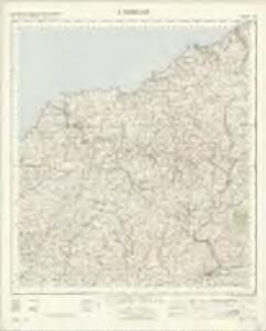
Cardigan - OS One-Inch Map
1 : 63360 Topographic maps Ordnance Survey Ordnance Survey
Cardigan
1 : 31680 This plan of part of Cardiganshire shows the county town on the,north bank of the,River Teify as it,enters Cardigan,Bay. Further inland, the landscape is dominated by moorland and the peaks of the Presely Mountains, represented by dense brushwork interlining ('hachuring'). The huge blue stones,that make up,the ancient ceremonial site of Stonehenge came from these mountains -,a journey of some 200 miles. Budgen, Thomas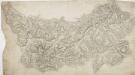
Newcastle-in-Emlyn
1 : 31680 This plan of North Carmarthenshire shows the Teify Valley at the top, with settlements, enclosed farmland and densely wooded areas dominating the valley landscape. Mynydd Llanllwni and Pencarreg depicted at the bottom of the sheet form the valley's distinctive backdrop. Rising steeply from the valley, the rounded and open plateau summit of Mynydd Llanllwni contains extensive areas of moorland and common land, represented by open dots on the plan. Budgen, Thomas
Llangranog (Hills) - OS One-Inch Revised New Series
1 : 63360 Topographic maps Ordnance Survey Ordnance Survey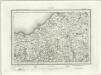
Llangranog (Outline) - OS One-Inch Revised New Series
1 : 63360 Topographic maps Ordnance Survey Ordnance Survey
Newcastle Emlyn (Hills) - OS One-Inch Revised New Series
1 : 63360 Topographic maps Ordnance Survey Ordnance Survey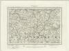
Newcastle Emlyn (Outline) - OS One-Inch Revised New Series
1 : 63360 Topographic maps Ordnance Survey Ordnance Survey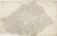
Lampeter
1 : 31680 This plan of Cardigan Bay and part of the county of Cardiganshire shows Lampeter and other settlements at lower left along the River Teify Valley. Pointed rocks below sharp cliffs, characteristic of the Cardiganshire coastline, are illustrated in elevation. Budgen, Thomas
Carmarthen(002OSD000000010U00136000)
1 : 31680 Sand dunes and marshland dominate the landscape of Carmarthen Bay on the Bristol Channel at the bottom of this chart. The map is drawn on three sheets pieced together with detail extending over the joins. Place names are difficult to read where the drawing is ripped and worn, but the path of the River Taff is clearly plotted from centre left of the map, crossing the county until it reaches the sea at Laugharne. Archaeological details are documented even though this did not become obligatory until 1816. Budgen, Thomas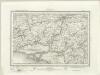
Carmarthen (Outline) - OS One-Inch Revised New Series
1 : 63360 Topographic maps Ordnance Survey Ordnance Survey
Carmarthen (Hills) - OS One-Inch Revised New Series
1 : 63360 Topographic maps Ordnance Survey Ordnance Survey
Carmarthen(002OSD000000010U00137000)
1 : 31680 This plan comprises two sheets joined together, depicting Carmarthen Bay on the Bristol Channel and the upper tidal reaches of the River Towy. The irregularly shaped paper is so worn that much of the detail is now erased. Sand dunes and marshland dominate the landscape of the Cefn Sidan Sands at the bottom of the chart and a faded aquamarine wash remains visible on the Rivers Taf and Towy. Budgen, Thomas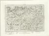
Cardigan (Outline) - OS One-Inch Revised New Series
1 : 63360 Topographic maps Ordnance Survey Ordnance Survey
Cardigan (Hills) - OS One-Inch Revised New Series
1 : 63360 Topographic maps Ordnance Survey Ordnance Survey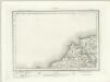
Cardigan (Outline) - OS One-Inch Revised New Series
1 : 63360 Topographic maps Ordnance Survey Ordnance Survey
Cardigan (Hills) - OS One-Inch Revised New Series
1 : 63360 Topographic maps Ordnance Survey Ordnance Survey
SN14 & Parts of SN15 - OS 1:25,000 Provisional Series Map
1 : 25000 Topographic maps Ordnance Survey Ordnance Survey
SN25 & Parts of SN15 - OS 1:25,000 Provisional Series Map
1 : 25000 Topographic maps Ordnance Survey Ordnance Survey
SN13 - OS 1:25,000 Provisional Series Map
1 : 25000 Topographic maps Ordnance Survey Ordnance Survey
SN24 - OS 1:25,000 Provisional Series Map
1 : 25000 Topographic maps Ordnance Survey Ordnance Survey
SN12 - OS 1:25,000 Provisional Series Map
1 : 25000 Topographic maps Ordnance Survey Ordnance Survey
SN35 & Parts of SN36 - OS 1:25,000 Provisional Series Map
1 : 25000 Topographic maps Ordnance Survey Ordnance Survey
SN23 - OS 1:25,000 Provisional Series Map
1 : 25000 Topographic maps Ordnance Survey Ordnance Survey
SN11 - OS 1:25,000 Provisional Series Map
1 : 25000 Topographic maps Ordnance Survey Ordnance Survey
SN34 - OS 1:25,000 Provisional Series Map
1 : 25000 Topographic maps Ordnance Survey Ordnance Survey
SN22 - OS 1:25,000 Provisional Series Map
1 : 25000 Topographic maps Ordnance Survey Ordnance Survey
SN33 - OS 1:25,000 Provisional Series Map
1 : 25000 Topographic maps Ordnance Survey Ordnance Survey
SN21 - OS 1:25,000 Provisional Series Map
1 : 25000 Topographic maps Ordnance Survey Ordnance Survey
SN45 - OS 1:25,000 Provisional Series Map
1 : 25000 Topographic maps Ordnance Survey Ordnance Survey