Maps of Pembrokeshire

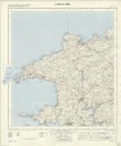
Fishguard - OS One-Inch Map
1 : 63360 Topographic maps Ordnance Survey Ordnance Survey
Pembroke - OS One-Inch Map
1 : 63360 Topographic maps Ordnance Survey Ordnance Survey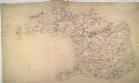
Haverfordwest
1 : 31680 This plan of the north Pembrokeshire coast and St David's Peninsula shows the low, gentle hills that characterise the peninsular landscape. The coast is illustrated with pointed rocks below the cliffs. Aber-Eiddy, indicated near the top margin of the sheet, is the only landing place along this stretch of a coastline battered by rough tides and strong winds. To the left of the sheet is the city of St David's. Named after the patron saint of Wales, it was a place of Christian pilgrimage during the Middle Ages. Two journeys to St David's equalled one journey to Rome, and hundreds of British pilgrims flocked each year to the shrine at St David's Cathedral. Budgen, Tomas
St David's (Outline) - OS One-Inch Revised New Series
1 : 63360 Topographic maps Ordnance Survey Ordnance Survey
St David's (Hills) - OS One-Inch Revised New Series
1 : 63360 Topographic maps Ordnance Survey Ordnance Survey
Milford (Outline) - OS One-Inch Revised New Series
1 : 63360 Topographic maps Ordnance Survey Ordnance Survey
Milford (Hills) - OS One-Inch Revised New Series
1 : 63360 Topographic maps Ordnance Survey Ordnance Survey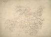
Fishguard
1 : 31680 This plan shows North Pembrokeshire and the Fishguard Bay, with Llanllowar Mountain and other peaks of the Preseli Mountains near the right margin of the sheet. Fishguard was the scene of the last invasion of Britain. In 1797, French warships were fired on by the cannons of Fishguard Fort, indicated in red just outside the town. Budgen, Thomas
Milford Haven
1 : 31680 This plan of the Cleddau estuary shows the new towns and dockyards at Milford Haven and Pembroke Dock. In 1790, Parliament granted Sir William Hamilton permission to build a new port on the north bank of the Cleddau estuary. Quaker whalers from Nantucket settled in Milford Haven in 1793. Four years later, the Navy Board established a dockyard here to build warships. Near the right margin of the sheet, on the south bank of the Cleddau, the new town of Pembroke Dock is indicated by the letter ''F''. Founded in 1814, and reliant on industry generated by the dockyard, Pembroke Dock flourished as the original New Town of the 19th century. Budgen, Thomas
Ports & Harbours on the South-West Coast of England.
Fullarton, A. & Co.
Tenby
1 : 31680 This plan of the Pembrokeshire coast shows the deep-sea port of Tenby at lower right and the River Cleddau Valley, with its broad tidal estuary flowing into Milford Haven, at lower left. Tidal rivers, called 'pills' on this plan, are a peculiar feature of the south Pembrokeshire landscape. Along the banks of one of the pills is the small settlement of Carew with the remains of an 11th-century castle and tidal mill indicated. Budgen, Thomas
Cardigan (Outline) - OS One-Inch Revised New Series
1 : 63360 Topographic maps Ordnance Survey Ordnance Survey
Cardigan (Hills) - OS One-Inch Revised New Series
1 : 63360 Topographic maps Ordnance Survey Ordnance Survey
Haverfordwest (Outline) - OS One-Inch Revised New Series
1 : 63360 Topographic maps Ordnance Survey Ordnance Survey
Haverfordwest (Hills) - OS One-Inch Revised New Series
1 : 63360 Topographic maps Ordnance Survey Ordnance Survey
Plan of Milford Haven
This is a plan of Milford Haven in Wales. It is perhaps associated with proposals in the mid 1590’s for using Milford Haven as a naval base against a Spanish invasion of the Bristol Channel and the Severn. The purpose of the plan seems to be to illustrate roads and anchorages in the Haven which are indicated by ships and a galley at anchor. The map betrays concern with invasion by sea as the coast line is shown in elevation whereas no inland detail is recorded. In August 1595 the Earl of Essex advised the Queen, against the enemy’s design upon Wales and the River of Severn. The Anglo- Spanish relationship had steadily deteriorated since the accession of the Protestant Elizabeth I. Raids on transatlantic shipping by English seamen such as Francis Drake and England’s support of the Protestant rebellion in the Spanish ruled Netherlands had brought tensions with Spain to a crescendo culminating in the events of the Spanish Armada. Although the Spanish Armada was defeated by the English in 1588 England remained at war with Spain for many years and further attempts to invade were made by Philip II with a second Armada’ dispersed in October 1596.
SM83 & Parts of SM73 & SM84 - OS 1:25,000 Provisional Series Map
1 : 25000 Topographic maps Ordnance Survey Ordnance Survey
SM72 & Parts of SM73 - OS 1:25,000 Provisional Series Map
1 : 25000 Topographic maps Ordnance Survey Ordnance Survey
SM82 - OS 1:25,000 Provisional Series Map
1 : 25000 Topographic maps Ordnance Survey Ordnance Survey
SM70 & Parts of SM71 - OS 1:25,000 Provisional Series Map
1 : 25000 Topographic maps Ordnance Survey Ordnance Survey
SM93 & Parts of SM94 - OS 1:25,000 Provisional Series Map
1 : 25000 Topographic maps Ordnance Survey Ordnance Survey
SM81 - OS 1:25,000 Provisional Series Map
1 : 25000 Topographic maps Ordnance Survey Ordnance Survey
SN04 - OS 1:25,000 Provisional Series Map
1 : 25000 Topographic maps Ordnance Survey Ordnance Survey
SM92 - OS 1:25,000 Provisional Series Map
1 : 25000 Topographic maps Ordnance Survey Ordnance Survey
SM80 - OS 1:25,000 Provisional Series Map
1 : 25000 Topographic maps Ordnance Survey Ordnance Survey
SN03 - OS 1:25,000 Provisional Series Map
1 : 25000 Topographic maps Ordnance Survey Ordnance Survey
SM91 - OS 1:25,000 Provisional Series Map
1 : 25000 Topographic maps Ordnance Survey Ordnance Survey
SN02 - OS 1:25,000 Provisional Series Map
1 : 25000 Topographic maps Ordnance Survey Ordnance Survey
SM90 - OS 1:25,000 Provisional Series Map
1 : 25000 Topographic maps Ordnance Survey Ordnance Survey