Maps of St Edmundsbury

Bury St Edmunds - OS One-Inch Map
1 : 63360 Topographic maps Ordnance Survey Ordnance Survey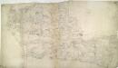
E. Harling
1 : 31680 The words 'Trig Point' are noted to the far left of the drawing, below Bodney. They indicate points from which angular measurements were taken in order to plot accurately the location of prominent landscape features. The pencil interlining ('hachuring') and shading that indicate relief have been lightly applied, leaving the road network clearly visible. The detail with which the roads are rendered is indicative of the Ordnance Survey's military imperative. Metcalf, Edward B.
Bury St Edmunds
The landscape here still reflected its medieval character in the early nineteeth century, as is seen through the dominance of named common fields, heaths and warrens. Eldon Field, Downham Warren, and Cutford Heath are just a few of the large labelled tracts of land appearing on this map. Stanley, William.
Thetford (Hills) - OS One-Inch Revised New Series
1 : 63360 Topographic maps Ordnance Survey Ordnance Survey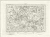
Thetford (Outline) - OS One-Inch Revised New Series
1 : 63360 Topographic maps Ordnance Survey Ordnance Survey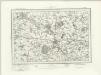
Bury St Edmunds (Outline) - OS One-Inch Revised New Series
1 : 63360 Topographic maps Ordnance Survey Ordnance Survey
Bury St Edmunds (Hills) - OS One-Inch Revised New Series
1 : 63360 Topographic maps Ordnance Survey Ordnance Survey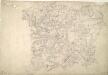
Stow Market
1 : 31680 This is a plan of the Gipping Valley in Suffolk. The circular hole in the top left-hand margin indicates that an 'Ordnance Office Copy' blind stamp has been removed from the manuscript. The die has cut through the paper causing the stamp to fall out. Pencil rays intersect across the map, evidence of measurements taken by the surveyor between fixed triangulation points. Stanley, William
Bury St. Edmunds
1 : 31680 .Built in 1795 to display the paintings and silverware of the fourth Earl of Bristol, Ickworth House is depicted near the top left of the map along the road leading south-west to Haverhill. The abbey of Bury St Edmunds is indicated by a cross. The abbey, built shortly after the Norman Conquest of 1066, housed a thriving monastic community until its dissolution in 1539. A prison and windmills are noted outside Bury St Edmunds. Metcalf, Edward B.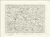
Eye (Outline) - OS One-Inch Revised New Series
1 : 63360 Topographic maps Ordnance Survey Ordnance Survey
Eye (Hills) - OS One-Inch Revised New Series
1 : 63360 Topographic maps Ordnance Survey Ordnance Survey
Diss (Hills) - OS One-Inch Revised New Series
1 : 63360 Topographic maps Ordnance Survey Ordnance Survey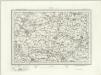
Diss (Outline) - OS One-Inch Revised New Series
1 : 63360 Topographic maps Ordnance Survey Ordnance Survey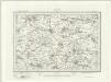
Swaffham (Outline) - OS One-Inch Revised New Series
1 : 63360 Topographic maps Ordnance Survey Ordnance Survey
Swaffham (Hills) - OS One-Inch Revised New Series
1 : 63360 Topographic maps Ordnance Survey Ordnance Survey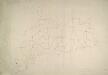
Eye
1 : 31680 This unfinished drawing of the Suffolk lowlands shows only the network of roads around Eye. A few of the roads and settlements have been inked in. Stanley, William
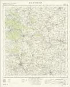
TM09 - OS 1:25,000 Provisional Series Map
1 : 25000 Topographic maps Ordnance Survey Ordnance Survey
TM08 - OS 1:25,000 Provisional Series Map
1 : 25000 Topographic maps Ordnance Survey Ordnance Survey
TL99 - OS 1:25,000 Provisional Series Map
1 : 25000 Topographic maps Ordnance Survey Ordnance Survey
TM07 - OS 1:25,000 Provisional Series Map
1 : 25000 Topographic maps Ordnance Survey Ordnance Survey
TM15 - OS 1:25,000 Provisional Series Map
1 : 25000 Topographic maps Ordnance Survey Ordnance Survey
TL98 - OS 1:25,000 Provisional Series Map
1 : 25000 Topographic maps Ordnance Survey Ordnance Survey
TM06 - OS 1:25,000 Provisional Series Map
1 : 25000 Topographic maps Ordnance Survey Ordnance Survey
TL89 - OS 1:25,000 Provisional Series Map
1 : 25000 Topographic maps Ordnance Survey Ordnance Survey
TL97 - OS 1:25,000 Provisional Series Map
1 : 25000 Topographic maps Ordnance Survey Ordnance Survey
TM05 - OS 1:25,000 Provisional Series Map
1 : 25000 Topographic maps Ordnance Survey Ordnance Survey
TL88 - OS 1:25,000 Provisional Series Map
1 : 25000 Topographic maps Ordnance Survey Ordnance Survey
TL96 - OS 1:25,000 Provisional Series Map
1 : 25000 Topographic maps Ordnance Survey Ordnance Survey
TL87 - OS 1:25,000 Provisional Series Map
1 : 25000 Topographic maps Ordnance Survey Ordnance Survey