Maps of Bromyard and Winslow

Ludlow - OS One-Inch Map
1 : 63360 Topographic maps Ordnance Survey Ordnance Survey
Bishop's Castle
1 : 31680 The River Clun Valley dominates the right-hand section of this plan of Shropshire. To the left is Clun Forest, famous for the sheep of the same name. The plan shows a section of the Offa's Dike running from top left towards bottom right. Extending 176 miles along the English border from the northern Welsh coast south to Chepstow,this great earth bank is eight miles longer than Hadrian's Wall. Unlike Hadrian's Wall, it was never garrisoned. Budgen, Thomas
Actual Survey of the County of Salop
Rocque, John
Actual survey of the county of Salop, 3
1 Blatt : 71 x 53 cm John Rocque
Presteigne
1 : 31680 The Roman road, south to Hereford and beyond, runs across the Arrow Valley and Shobdon Marshes from top to bottom of this plan., At lower right, the River Arrow joins the River Lugg south of Leominster., The surrounding countryside appears intensively farmed., Throughout this region of Herefordshire,,based on rich red clay, farmland,dominates,in a,landscape of,well-hedged fields scattered,with small woods and threaded by,streams and brooks. Budgen, Thomas
New map of the county of Hereford, 1
1 Blatt : 71 x 58 cm s.n.
New map of the county of Hereford, 2
1 Blatt : 71 x 58 cm s.n.
Much Wenlock
1 : 31680 This plan,of,part of East Shropshire is dominated by Wenlock Edge., Running from the bottom left of the drawing to the top right, this,heavily,wooded,limestone ridge,extends for 16 miles across Shropshire.,,It shelves steeply into the patchwork fields of Ape Dale on its,western face, and,slopes gently into the Corve Dale to the east., The remains of the ancient Long Forest are also noted. Stevens, Henry
Bromyard
Most of the common land in Hertsfordshire is included in this map, which covers Bromyard Down, Badley Wood, and Bringsty Common. Sutton Walls, an Iron Age hillfort, is north of the River Lugg. Budgen, T.
Bromyard
Most of the common land in Hertsfordshire is included in this map, which covers Bromyard Down, Badley Wood, and Bringsty Common. Sutton Walls, an Iron Age hillfort, is north of the River Lugg. Budgen, T.
Church Stretton (Hills) - OS One-Inch Revised New Series
1 : 63360 Topographic maps Ordnance Survey Ordnance Survey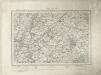
Church Stretton (Outline) - OS One-Inch Revised New Series
1 : 63360 Topographic maps Ordnance Survey Ordnance Survey
Ludlow (Hills) - OS One-Inch Revised New Series
1 : 63360 Topographic maps Ordnance Survey Ordnance Survey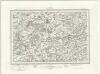
Ludlow (Outline) - OS One-Inch Revised New Series
1 : 63360 Topographic maps Ordnance Survey Ordnance Survey
Cleobury Mortimer
1 : 31680 The two smooth humps of Brown Clee Hill dominate the landscape east of Ludlow. With its summit rising to 1,772 ft, Brown Clee is the highest point in Shropshire and was,an iron-age settlement, hosting three hillforts.,Below Brown Clee, the plan shows another isolated hill fort at Titterstone Clee.,At an altitude of,1,750 ft,,this fort is one of the highest and largest in Britain. , Stevens, Henry
Hereford (Outline) - OS One-Inch Revised New Series
1 : 63360 Topographic maps Ordnance Survey Ordnance Survey
Hereford (Hills) - OS One-Inch Revised New Series
1 : 63360 Topographic maps Ordnance Survey Ordnance Survey
SO39 - OS 1:25,000 Provisional Series Map
1 : 25000 Topographic maps Ordnance Survey Ordnance Survey
SO38 - OS 1:25,000 Provisional Series Map
1 : 25000 Topographic maps Ordnance Survey Ordnance Survey
SO37 - OS 1:25,000 Provisional Series Map
1 : 25000 Topographic maps Ordnance Survey Ordnance Survey
SO49 - OS 1:25,000 Provisional Series Map
1 : 25000 Topographic maps Ordnance Survey Ordnance Survey
SO36 - OS 1:25,000 Provisional Series Map
1 : 25000 Topographic maps Ordnance Survey Ordnance Survey
SO48 - OS 1:25,000 Provisional Series Map
1 : 25000 Topographic maps Ordnance Survey Ordnance Survey
SO35 - OS 1:25,000 Provisional Series Map
1 : 25000 Topographic maps Ordnance Survey Ordnance Survey
SO47 - OS 1:25,000 Provisional Series Map
1 : 25000 Topographic maps Ordnance Survey Ordnance Survey
SO59 - OS 1:25,000 Provisional Series Map
1 : 25000 Topographic maps Ordnance Survey Ordnance Survey
SO46 - OS 1:25,000 Provisional Series Map
1 : 25000 Topographic maps Ordnance Survey Ordnance Survey
SO58 - OS 1:25,000 Provisional Series Map
1 : 25000 Topographic maps Ordnance Survey Ordnance Survey
SO45 - OS 1:25,000 Provisional Series Map
1 : 25000 Topographic maps Ordnance Survey Ordnance Survey