Maps of Powys

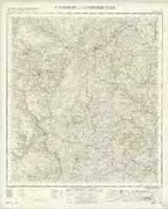
Montgomery and Llandrindod Wells - OS One-Inch Map
1 : 63360 Topographic maps Ordnance Survey Ordnance Survey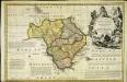
An accurate map of Radnor Shire
1 Karte : Kupferdruck ; 33 x 51 cm Kitchin; Tinney John Tinney
Radnoria comitatvs
1 Karte : Kupferdruck ; 37 x 48 cm Blaeu Joan Blaeu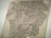
Llandrindod
1 : 31680 This plan of part of Powis,depicts the uplands of the Radnor Forest, to the right of the sheet. A mix of dispersed farmland and commonland,along the valley of the Ithon River dominates the landscape of this,central part of,Wales. Budgen, Thomas
Newtown
1 : 31680 The River Severn Valley,features,runs,from left to right on this plan of part of mid- Wales. With its source high on the Cumbrian Mountains, the river flows through,a narrow rocky channel in its upper course, becoming wider and deeper in its middle course and its valley flatter. Budgen, Thomas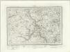
Rhyader (Outline) - OS One-Inch Revised New Series
1 : 63360 Topographic maps Ordnance Survey Ordnance Survey
Rhyader (Hills) - OS One-Inch Revised New Series
1 : 63360 Topographic maps Ordnance Survey Ordnance Survey
Llanidloes (Hills) - OS One-Inch Revised New Series
1 : 63360 Topographic maps Ordnance Survey Ordnance Survey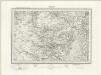
Llanidloes (Outline) - OS One-Inch Revised New Series
1 : 63360 Topographic maps Ordnance Survey Ordnance Survey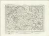
Montgomery (Outline) - OS One-Inch Revised New Series
1 : 63360 Topographic maps Ordnance Survey Ordnance Survey
Montgomery (Hills) - OS One-Inch Revised New Series
1 : 63360 Topographic maps Ordnance Survey Ordnance Survey
Knighton (Hills) - OS One-Inch Revised New Series
1 : 63360 Topographic maps Ordnance Survey Ordnance Survey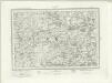
Knighton (Outline) - OS One-Inch Revised New Series
1 : 63360 Topographic maps Ordnance Survey Ordnance Survey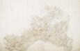
Llanidloes
1 : 31680 In this partly finished plan of central Wales, colour washes depicting relief are combined with numerical annotations in red ink to describe the contours and height of the land. An area calculation table survives in black ink at the bottom margin, the area mapped being recorded as 52.5502 square miles. Archaeological details are named in gothic lettering. Budgen, Thomas Jr.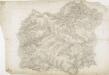
Hafod, Llanidloes
1 : 31680 .This plan of the,Ystwyth valley in the Cambrian Mountains is formally titled. The scale of the drawing is noted and the area of the land recorded,as 183.0453 square miles. Archaeological sites are named in gothic script. Colour washes depicting relief are combined with numerical annotations ('spot heights'), in red and black ink, indicating the height of the hills. The altitudes in red ink,are trigonometrically ascertained; those in black are estimated. Dawson, Robert
Builth
1 : 31680 These field sketches of the Irfon Valley in central Wales were made on several pieces of thin and irregularly cut paper, joined and laid down on thick paper. The assemblage was cut into 12 rectangular pieces, each approximately 200 x 310mm, then remounted to form one sheet. The many pencil notes on the drawing were made before the sheet was cut. The map provides a good illustration of the convention of 'relative command', which indicates the relative height of the hills using black ink numbers: Hill 3 being higher than Hill 2, for example. Brushwork interlining and ink washes further depict relief. Dawson, Robert
Glasllyn
1 : 31680 This drawing is formally titled. The scale is recorded and the area of land surveyed noted in square miles. A triangulation diagram appears on the reverse of the drawing. Trigonometrical points are marked by a dot within a triangle.,From these,points, the surveyor took angular measurements to plot prominent features of the landscape. Lack of shading to,indicate relief suggests that this is an intermediate,drawing rather than,the finished version. Faint pencil lines form a border around the plan. The top-right corner of the border is marked 'Sheet Edge' to identify,the intended borders of the finished drawing. Giles, John C
Builth (Hills) - OS One-Inch Revised New Series
1 : 63360 Topographic maps Ordnance Survey Ordnance Survey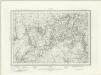
Builth (Outline) - OS One-Inch Revised New Series
1 : 63360 Topographic maps Ordnance Survey Ordnance Survey
SN99 - OS 1:25,000 Provisional Series Map
1 : 25000 Topographic maps Ordnance Survey Ordnance Survey
SN98 - OS 1:25,000 Provisional Series Map
1 : 25000 Topographic maps Ordnance Survey Ordnance Survey
SN97 - OS 1:25,000 Provisional Series Map
1 : 25000 Topographic maps Ordnance Survey Ordnance Survey
SO09 - OS 1:25,000 Provisional Series Map
1 : 25000 Topographic maps Ordnance Survey Ordnance Survey
SN96 - OS 1:25,000 Provisional Series Map
1 : 25000 Topographic maps Ordnance Survey Ordnance Survey
SO08 - OS 1:25,000 Provisional Series Map
1 : 25000 Topographic maps Ordnance Survey Ordnance Survey
SN95 - OS 1:25,000 Provisional Series Map
1 : 25000 Topographic maps Ordnance Survey Ordnance Survey
SO07 - OS 1:25,000 Provisional Series Map
1 : 25000 Topographic maps Ordnance Survey Ordnance Survey
SO19 - OS 1:25,000 Provisional Series Map
1 : 25000 Topographic maps Ordnance Survey Ordnance Survey
SO06 - OS 1:25,000 Provisional Series Map
1 : 25000 Topographic maps Ordnance Survey Ordnance Survey