Maps of Telford and Wrekin

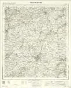
Shrewsbury - OS One-Inch Map
1 : 63360 Topographic maps Ordnance Survey Ordnance Survey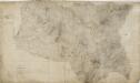
Shrewsbury
1 : 31680 The drawing of this,plan was,begun in 1817 and completed in 1827.,,Because of,many erasures and corrections, the drawing is cracked and dirty, and therefore hard to read. An area calculation table survives in black ink,in the,bottom left margin. Stevens, Henry
Actual survey of the county of Salop, 1
1 Blatt : 71 x 53 cm John Rocque
Actual Survey of the County of Salop
Rocque, John
Actual survey of the county of Salop, 2
1 Blatt : 71 x 53 cm John Rocque
Actual Survey of the County of Salop
Rocque, John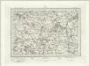
Wem (Outline) - OS One-Inch Revised New Series
1 : 63360 Topographic maps Ordnance Survey Ordnance Survey
Wem (Hills) - OS One-Inch Revised New Series
1 : 63360 Topographic maps Ordnance Survey Ordnance Survey
Shrewsbury (Hills) - OS One-Inch Revised New Series
1 : 63360 Topographic maps Ordnance Survey Ordnance Survey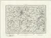
Shrewsbury (Outline) - OS One-Inch Revised New Series
1 : 63360 Topographic maps Ordnance Survey Ordnance Survey
Part of Shropshire containing 126 square miles. Surveyed and Drawn by H. Stevens R. M. D. 1816''
1 : 31680 .This is the first map to conform fully to the 1816 Ordnance Survey Circular, which stated that every plan was to,have an area title, survey and drawing date,,and a note of,its author's,name and rank.,The,map shows,a section of Offa's Dyke, the great earth bank running 176 miles along or near the English border from the North Wales coast south to Chepstow., Offa's Dyke is eight miles longer than Hadrian's Wall but, because it was not a stone construction, was never garrisoned., Its purpose was to mark rathen than defend the frontier. Stevens, Henry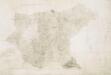
Wem
1 : 31680 This plan shows northern Shropshire and its border with Cheshire and Flintshire. The Ellesmere Canal is marked in blue. The draughtsman has recorded the individual locks, most notably on the section leading towards Whitchurch. An area calculation table survives in black ink in the right margin. Stevens, Henry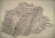
Much Wenlock
1 : 31680 This plan,of,part of East Shropshire is dominated by Wenlock Edge., Running from the bottom left of the drawing to the top right, this,heavily,wooded,limestone ridge,extends for 16 miles across Shropshire.,,It shelves steeply into the patchwork fields of Ape Dale on its,western face, and,slopes gently into the Corve Dale to the east., The remains of the ancient Long Forest are also noted. Stevens, Henry
Nantwich (Outline) - OS One-Inch Revised New Series
1 : 63360 Topographic maps Ordnance Survey Ordnance Survey
Nantwich (Hills) - OS One-Inch Revised New Series
1 : 63360 Topographic maps Ordnance Survey Ordnance Survey
Market Drayton
1 : 31680 This plan covers the Shropshire,Northern Plain, near the border with Cheshire and Staffordshire. The area,is characterised by small woodlands, formal parkland, meres (lakes), mosses, pools and other wetland habitats. Mills are indicated near the town of Market Drayton, central towards the top,,where about two hundred workers were employed in the manufacture of horse-hair products. Stevens, Henry
Combermere
1 : 31680 This drawing is formally titled at the top of the sheet. The draughtsman has made an annotation in ink along a yellow line, reading: 'Judged place of the North Edge of the Drayton sheet'. Sections of the Ellesmere Canal and the Birmingham and Chester Canal are shown in blue with individual locks indicated. Stevens, Henry
SJ33 - OS 1:25,000 Provisional Series Map
1 : 25000 Topographic maps Ordnance Survey Ordnance Survey
SJ32 - OS 1:25,000 Provisional Series Map
1 : 25000 Topographic maps Ordnance Survey Ordnance Survey
SJ31 - OS 1:25,000 Provisional Series Map
1 : 25000 Topographic maps Ordnance Survey Ordnance Survey
SJ43 - OS 1:25,000 Provisional Series Map
1 : 25000 Topographic maps Ordnance Survey Ordnance Survey
SJ30 - OS 1:25,000 Provisional Series Map
1 : 25000 Topographic maps Ordnance Survey Ordnance Survey
SJ42 - OS 1:25,000 Provisional Series Map
1 : 25000 Topographic maps Ordnance Survey Ordnance Survey
SJ41 - OS 1:25,000 Provisional Series Map
1 : 25000 Topographic maps Ordnance Survey Ordnance Survey
SJ53 - OS 1:25,000 Provisional Series Map
1 : 25000 Topographic maps Ordnance Survey Ordnance Survey
SJ40 - OS 1:25,000 Provisional Series Map
1 : 25000 Topographic maps Ordnance Survey Ordnance Survey
SJ52 - OS 1:25,000 Provisional Series Map
1 : 25000 Topographic maps Ordnance Survey Ordnance Survey
SJ51 - OS 1:25,000 Provisional Series Map
1 : 25000 Topographic maps Ordnance Survey Ordnance Survey
SJ63 - OS 1:25,000 Provisional Series Map
1 : 25000 Topographic maps Ordnance Survey Ordnance Survey