Maps of Lincolnshire

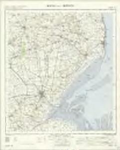
Boston and Skegness - OS One-Inch Map
1 : 63360 Topographic maps Ordnance Survey Ordnance Survey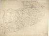
Boston
This drawing covers the part of Lincolnshire known as South Holland. It shows the saltmarshes, intertidal banks of sand and mud, shallow waters and deep channels that characterise the Wash, the largest estuarine system in Britain. Depicted further inland, to the left of the sheet, are ancient cattle droves, the long straight roads that are a prominent feature of this part of Lincolnshire. Budgen, Charles
Tattershall(002OSD000000013U00243000)
1 : 31680 This drawing covers part of the Lincolnshire coast. It shows sand dunes and silt and the navigable portion off the coast known as the Boston Deeps on the right of the sheet. Canals and dykes are a manmade feature of the East Fen and are highlighted in blue towards the left of the plan. These date from the 17th century, when James I appointed Dutch engineer Cornelius Vermuyden to direct the drainage of the fens wetlands. Many local people opposed the scheme as the plan involved commonland on which they grazed cattle. As a result of Vermuyden's work, the Fens changed radically in appearance, from an area of flooded marshes to one of extensively farmed agricultural land. Budgen, Charles
Tattershall(002OSD000000013U00242000)
1 : 31680 Dikes and canals constructed to drain the fens are the prominent feature of this plan of the West Fen in Lincolnshire. These date from the 17th century, when James I appointed Dutch engineer Cornelius Vermuyden to direct the drainage of the wetlands. Many local people opposed the scheme as the plan involved commonland on which they grazed cattle. As a result of Vermuyden's work, the fens changed radically in appearance, from an area of flooded marshes to one of extensively farmed agricultural land. Budgen, Charles
Horncastle (Hills) - OS One-Inch Revised New Series
1 : 63360 Topographic maps Ordnance Survey Ordnance Survey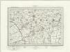
Horncastle (Outline) - OS One-Inch Revised New Series
1 : 63360 Topographic maps Ordnance Survey Ordnance Survey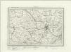
Boston (Outline) - OS One-Inch Revised New Series
1 : 63360 Topographic maps Ordnance Survey Ordnance Survey
Boston (Hills) - OS One-Inch Revised New Series
1 : 63360 Topographic maps Ordnance Survey Ordnance Survey
The Wash (Hills) - OS One-Inch Revised New Series
1 : 63360 Topographic maps Ordnance Survey Ordnance Survey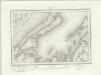
The Wash (Outline) - OS One-Inch Revised New Series
1 : 63360 Topographic maps Ordnance Survey Ordnance Survey
Skegness (Hills) - OS One-Inch Revised New Series
1 : 63360 Topographic maps Ordnance Survey Ordnance Survey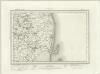
Skegness (Outline) - OS One-Inch Revised New Series
1 : 63360 Topographic maps Ordnance Survey Ordnance Survey
Alford
1 : 31680 This plan covers an area of Lincolnshire from Thrustorpe in the north to Skegness in the south. Sandy beaches, characteristic of the coastline, are represented by banks of yellow dots on a paler yellow wash. The locations of various hotels are indicated along the coast. Further inland, symbols formed of three vertically inclined strokes above a short horizontal line are used to indicate salt marshes. Stevens, H.
Holbeach
1 : 31680 This drawing covers parts of Lincolnshire and Cambridgeshire, showing the River Witham at the top of the sheet flowing south-eastwards into Boston and the Wash. Drains across fens and marshland are highlighted in blue towards the lower part of the plan. These date from the 17th century, when James I appointed Dutch engineer, Cornelius Vermuyden to direct the drainage of the wetlands. Many local people opposed the scheme since it included commonland on which they grazed cattle. As a result of Vermuyden's work, the fens changed radically in appearance, from an area of flooded marshes to one of extensively farmed land. Yeakell, Thomas Jr.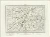
Spalding (Outline) - OS One-Inch Revised New Series
1 : 63360 Topographic maps Ordnance Survey Ordnance Survey
TF57 - OS 1:25,000 Provisional Series Map
1 : 25000 Topographic maps Ordnance Survey Ordnance Survey
TF56 - OS 1:25,000 Provisional Series Map
1 : 25000 Topographic maps Ordnance Survey Ordnance Survey
TF55 - OS 1:25,000 Provisional Series Map
1 : 25000 Topographic maps Ordnance Survey Ordnance Survey
TF47 - OS 1:25,000 Provisional Series Map
1 : 25000 Topographic maps Ordnance Survey Ordnance Survey
TF46 - OS 1:25,000 Provisional Series Map
1 : 25000 Topographic maps Ordnance Survey Ordnance Survey
TF45 - OS 1:25,000 Provisional Series Map
1 : 25000 Topographic maps Ordnance Survey Ordnance Survey
TF37 - OS 1:25,000 Provisional Series Map
1 : 25000 Topographic maps Ordnance Survey Ordnance Survey
TF44 & Parts of TF54 - OS 1:25,000 Provisional Series Map
1 : 25000 Topographic maps Ordnance Survey Ordnance Survey
TF36 - OS 1:25,000 Provisional Series Map
1 : 25000 Topographic maps Ordnance Survey Ordnance Survey
TF43 - OS 1:25,000 Provisional Series Map
1 : 25000 Topographic maps Ordnance Survey Ordnance Survey
TF35 - OS 1:25,000 Provisional Series Map
1 : 25000 Topographic maps Ordnance Survey Ordnance Survey
TF27 - OS 1:25,000 Provisional Series Map
1 : 25000 Topographic maps Ordnance Survey Ordnance Survey
TF34 - OS 1:25,000 Provisional Series Map
1 : 25000 Topographic maps Ordnance Survey Ordnance Survey
TF26 - OS 1:25,000 Provisional Series Map
1 : 25000 Topographic maps Ordnance Survey Ordnance Survey