Maps of Ayr
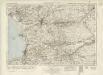
Kilmarnock & Ayr (78) - OS One-Inch map
1 : 63360 Topographic maps Ordnance Survey Ordnance Survey
Kilmarnock & Ayr (78) - OS One-Inch map
1 : 63360 Topographic maps Ordnance Survey Ordnance Survey
COILA PROVINCIA. | THE PROVINCE OF| KYLE.
Auct. Timoth: Pont. [Amsterdam : Joan Blaeu]
Coila provincia
1 Karte : Kupferdruck ; 44 x 55 cm Blaeu; Pont Joan Blaeu
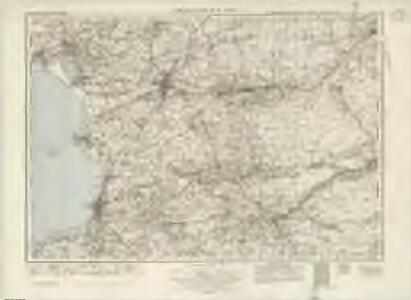
Ayrshire 2 N.
1 : 78000 Johnson, William, fl. 1806-1840
NS33 & Parts of NS23 - OS 1:25,000 Provisional Series Map
1 : 25000 Topographic maps Ordnance Survey Ordnance Survey
NS32 & Parts of NS22 - OS 1:25,000 Provisional Series Map
1 : 25000 Topographic maps Ordnance Survey Ordnance Survey
NS43 - OS 1:25,000 Provisional Series Map
1 : 25000 Topographic maps Ordnance Survey Ordnance Survey
NS42 - OS 1:25,000 Provisional Series Map
1 : 25000 Topographic maps Ordnance Survey Ordnance Survey
NS53 - OS 1:25,000 Provisional Series Map
1 : 25000 Topographic maps Ordnance Survey Ordnance Survey
NS52 - OS 1:25,000 Provisional Series Map
1 : 25000 Topographic maps Ordnance Survey Ordnance Survey
NS63 - OS 1:25,000 Provisional Series Map
1 : 25000 Topographic maps Ordnance Survey Ordnance Survey
NS62 - OS 1:25,000 Provisional Series Map
1 : 25000 Topographic maps Ordnance Survey Ordnance Survey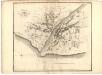
Plan of the Town and Parishes of Ayr, Newton upon Ayr & St. Quivox.
Wood, John, ca. 1780-1847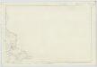
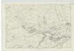
Ayrshire, Sheet XX - OS 6 Inch map
1 : 10560 Topographic maps Ordnance Survey Ordnance Survey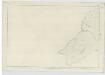
Lanarkshire, Sheet XXXV - OS 6 Inch map
1 : 10560 Topographic maps Ordnance Survey Ordnance Survey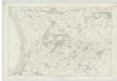
Ayrshire, Sheet XXII - OS 6 Inch map
1 : 10560 Topographic maps Ordnance Survey Ordnance Survey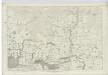
Ayrshire, Sheet XIX - OS 6 Inch map
1 : 10560 Topographic maps Ordnance Survey Ordnance Survey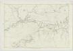
Ayrshire, Sheet XXX - OS 6 Inch map
1 : 10560 Topographic maps Ordnance Survey Ordnance Survey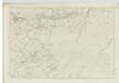
Ayrshire, Sheet XXIV - OS 6 Inch map
1 : 10560 Topographic maps Ordnance Survey Ordnance Survey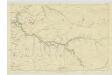
Ayrshire, Sheet XXXVI - OS 6 Inch map
1 : 10560 Topographic maps Ordnance Survey Ordnance Survey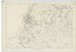
Ayrshire, Sheet XXXIII - OS 6 Inch map
1 : 10560 Topographic maps Ordnance Survey Ordnance Survey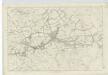
Ayrshire, Sheet XXIX - OS 6 Inch map
1 : 10560 Topographic maps Ordnance Survey Ordnance Survey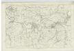
Ayrshire, Sheet XXXV - OS 6 Inch map
1 : 10560 Topographic maps Ordnance Survey Ordnance Survey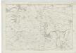
Ayrshire, Sheet XXIII - OS 6 Inch map
1 : 10560 Topographic maps Ordnance Survey Ordnance Survey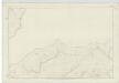
Ayrshire, Sheet XXV - OS 6 Inch map
1 : 10560 Topographic maps Ordnance Survey Ordnance Survey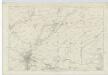
Ayrshire, Sheet XVIII - OS 6 Inch map
1 : 10560 Topographic maps Ordnance Survey Ordnance Survey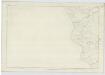
Lanarkshire, Sheet XXIX - OS 6 Inch map
1 : 10560 Topographic maps Ordnance Survey Ordnance Survey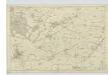
Ayrshire, Sheet XVII - OS 6 Inch map
1 : 10560 Topographic maps Ordnance Survey Ordnance Survey