Maps of Skerryvore
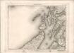
The west coast of Scotland from Ila to Mull.
Mackenzie, Murdoch (Senior), 1712-1797
Mvla insvla
1 Karte : Kupferdruck ; 41 x 53 cm Blaeu; Pont Joan Blaeu
Mula Insula, quae ex Aebudarum numero una est, et Lochabriae ad occasum praetenditur. The Yle of Mul whiche is one of the Westerne Yles, and lyeth ovir against Lochabyr / Auct. Timoth. Pont.
Pont, Timothy, 1560?-1614? Blaeu, Joan, 1596-1673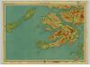
Mull & Iona, Sheet 10 - Bartholomew's "Half Inch to the Mile Maps" of Scotland
1 : 126720 Topographic maps John Bartholomew & Son, Ltd John Bartholomew & Son, Ltd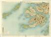
Mull, Sheet 10 - Bartholomew's "Half Inch to the Mile Maps" of Scotland
1 : 126720 Topographic maps Bartholomew, John George John Bartholomew & Co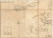
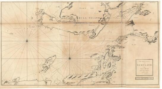
The west side of the island Mull with the islands Tiri and Coll.
Mackenzie, Murdoch (Senior), 1712-1797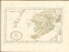

Colonsay - Bartholomew's 'Survey Atlas of Scotland'
1 : 126720 Topographic maps John Bartholomew & Son, Ltd John Bartholomew & Son, Ltd
Iona and Colonsay - OS One-Inch Map
1 : 63360 Topographic maps Ordnance Survey Ordnance Survey
MVLA INSVLA, | quæ ex Æbudarum numero una est, | et Lochabriæ ad occasum prætenditur. | THE YLE OF MVL | whiche is one of the westerne Yles, | and lyeth ovir [!] against Lochabyr
Auct. Timoth. Pont. [Amsterdam : Joan Blaeu]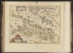
Lorna cum insulis vicinis et provinciis eidem conterminis. Lorn wt the Yles and provinces bordering there-upon / Auct. Timoth. Pont.
Pont, Timothy, 1560?-1614? Blaeu, Joan, 1596-1673
Ivra insvla
1 Karte : Kupferdruck ; 40 x 51 cm Blaeu; Pont Joan Blaeu
Iura Insula, The Yle of Iura one of the westerne Iles of Scotland / Auct. Timoth. Pont.
Pont, Timothy, 1560?-1614? Blaeu, Joan, 1596-1673
Lorna cum insulis vicinis et provinciis eidem conterminis
1 Karte : Kupferdruck ; 38 x 51 cm Blaeu; Pont Joan Blaeu
LORNA cum insulis vicinis | et provinciis eidem conterminis. | LORN Wt the Yles and provinces | bordering there-vpon.
Auct. Timoth. Pont. [Amsterdam : Joan Blaeu]
IVRA INSVLA | The Yle of IVRA | one of the westerne Iles | of SCOTLAND.
Auct. Timoth. Pont. [Amsterdam : Joan Blaeu]
Iona & Colonsay (59) - OS One-Inch map
1 : 63360 Topographic maps Ordnance Survey Ordnance Survey
Iona & Colonsay (59) - OS One-Inch map
1 : 63360 Topographic maps Ordnance Survey Ordnance Survey
North Jura & Firth of Lorne (60) - OS One-Inch map
1 : 63360 Topographic maps Ordnance Survey Ordnance Survey
North Jura & Firth of Lorne (60) - OS One-Inch map
1 : 63360 Topographic maps Ordnance Survey Ordnance Survey
Volume 1: Sheet 35 - Colonsay
1 : 63360 Farquharson, J.
Tiree - OS One-Inch map
1 : 63360 Topographic maps Ordnance Survey Ordnance Survey
Tiree - OS One-Inch map
1 : 63360 Topographic maps Ordnance Survey Ordnance Survey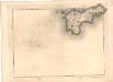
Tiree - OS One-Inch map
1 : 63360 Topographic maps Ordnance Survey Ordnance Survey
Colonsay - OS One-Inch map
1 : 63360 Topographic maps Ordnance Survey Ordnance Survey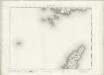
Colonsay - OS One-Inch map
1 : 63360 Topographic maps Ordnance Survey Ordnance Survey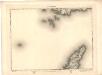
Colonsay - OS One-Inch map
1 : 63360 Topographic maps Ordnance Survey Ordnance Survey
Kilmartin - OS One-Inch map
1 : 63360 Topographic maps Ordnance Survey Ordnance Survey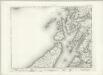
Kilmartin - OS One-Inch map
1 : 63360 Topographic maps Ordnance Survey Ordnance Survey