Maps of West Dunbartonshire
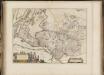
Levinia Vicecomitatus, [or],The Province of Lennox called the Shyre of Dun-Britton / Auct. Timoth. Pont.
Pont, Timothy, 1560?-1614? Blaeu, Joan, 1596-1673
Levinia, vice comitatvs
1 Karte : Kupferdruck ; 38 x 52 cm Blaeu; Pont Joan Blaeu
LEVINIA, | VICE COMITATVS. | The Province of LENNOX, | called the Shyre of Dun-Britton.
Auct: Timoth: Pont. [Amsterdam : Joan Blaeu]
The Shire of Lenox [i.e. Lennox] or Dunbarton / by H. Moll.
Moll, Herman, d. 1732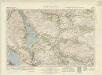
Loch Lomond (66) - OS One-Inch map
1 : 63360 Topographic maps Ordnance Survey Ordnance Survey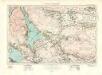
Loch Lomond (66) - OS One-Inch map
1 : 63360 Topographic maps Ordnance Survey Ordnance Survey
Volume 1: Sheet 30 - Glasgow
1 : 63360 Farquharson, J.
Glasgow - OS One-Inch map
1 : 63360 Topographic maps Ordnance Survey Ordnance Survey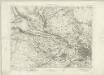
Glasgow - OS One-Inch map
1 : 63360 Topographic maps Ordnance Survey Ordnance Survey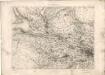
Glasgow - OS One-Inch map
1 : 63360 Topographic maps Ordnance Survey Ordnance Survey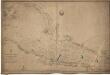
River Clyde, from Greenock to Dumbarton.
Great Britain. Hydrographic Office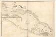
River Clyde from Dumbarton to Glasgow.
Great Britain. Hydrographic Office
NS28 - OS 1:25,000 Provisional Series Map
1 : 25000 Topographic maps Ordnance Survey Ordnance Survey
NS27 - OS 1:25,000 Provisional Series Map
1 : 25000 Topographic maps Ordnance Survey Ordnance Survey
NS38 - OS 1:25,000 Provisional Series Map
1 : 25000 Topographic maps Ordnance Survey Ordnance Survey
NS37 - OS 1:25,000 Provisional Series Map
1 : 25000 Topographic maps Ordnance Survey Ordnance Survey
NS48 - OS 1:25,000 Provisional Series Map
1 : 25000 Topographic maps Ordnance Survey Ordnance Survey
NS59 - OS 1:25,000 Provisional Series Map
1 : 25000 Topographic maps Ordnance Survey Ordnance Survey
NS47 - OS 1:25,000 Provisional Series Map
1 : 25000 Topographic maps Ordnance Survey Ordnance Survey
NS58 - OS 1:25,000 Provisional Series Map
1 : 25000 Topographic maps Ordnance Survey Ordnance Survey
NS57 - OS 1:25,000 Provisional Series Map
1 : 25000 Topographic maps Ordnance Survey Ordnance Survey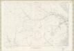
Dunbartonshire Sheet n X - OS 6 Inch map
1 : 10560 Topographic maps Ordnance Survey Ordnance Survey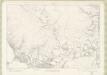
Dunbartonshire Sheet n XIII - OS 6 Inch map
1 : 10560 Topographic maps Ordnance Survey Ordnance Survey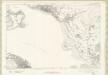
Dunbartonshire Sheet n XVII - OS 6 Inch map
1 : 10560 Topographic maps Ordnance Survey Ordnance Survey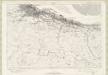
Dunbartonshire Sheet n XXI - OS 6 Inch map
1 : 10560 Topographic maps Ordnance Survey Ordnance Survey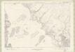
Dunbartonshire Sheet n XI - OS 6 Inch map
1 : 10560 Topographic maps Ordnance Survey Ordnance Survey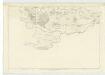
Stirlingshire, Sheet XXXII - OS 6 Inch map
1 : 10560 Topographic maps Ordnance Survey Ordnance Survey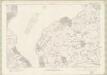
Dunbartonshire Sheet n XIV - OS 6 Inch map
1 : 10560 Topographic maps Ordnance Survey Ordnance Survey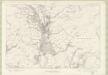
Dunbartonshire Sheet n XVIII - OS 6 Inch map
1 : 10560 Topographic maps Ordnance Survey Ordnance Survey
![Levinia Vicecomitatus, [or],The Province of Lennox called the Shyre of Dun-Britton / Auct. Timoth. Pont.](https://images-2.georeferencer.com/images/iiif/303161662083/full/,300/0/native.jpg)

