Maps of Newham
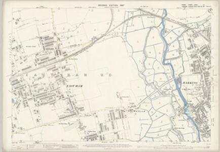
Essex (1st Ed/Rev 1862-96) LXXIII.12 (includes: Barking; East Ham) - 25 Inch Map
1 : 2500 Topographic maps Ordnance Survey Ordnance Survey
Essex (New Series 1913-) n LXXXVI.3 (includes: Barking; East Ham; Ilford) - 25 Inch Map
1 : 2500 Topographic maps Ordnance Survey Ordnance Survey
Essex (New Series 1913-) n LXXXVI.3 (includes: Barking; East Ham; Ilford) - 25 Inch Map
1 : 2500 Topographic maps Ordnance Survey Ordnance Survey
London (Edition of 1894-96) XLIV (includes: Barking; East Ham; Ilford) - 25 Inch Map
1 : 2500 Topographic maps Ordnance Survey Ordnance Survey
Essex (New Series 1913-) n LXXXVI.7 (includes: Barking; East Ham) - 25 Inch Map
1 : 2500 Topographic maps Ordnance Survey Ordnance Survey
London VIII.25 - OS London Town Plan
1 : 1056 Topographic maps Ordnance Survey Ordnance Survey
London VIII.15 - OS London Town Plan
1 : 1056 Topographic maps Ordnance Survey Ordnance Survey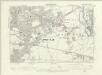
Essex LXXIII.SE - OS Six-Inch Map
1 : 10560 Topographic maps Ordnance Survey Ordnance Survey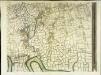
An exact survey of the city's of London Westminster , III
1 Blatt : 53 x 71 cm John Rocque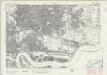
London Sheet L - OS Six-Inch Map
1 : 10560 Topographic maps Ordnance Survey Ordnance Survey
London Sheet L - OS Six-Inch Map
1 : 10560 Topographic maps Ordnance Survey Ordnance Survey
London VIII.NE - OS Six-Inch Map
1 : 10560 Topographic maps Ordnance Survey Ordnance Survey
Essex (New Series 1913-) n LXXXVI.2 (includes: East Ham; West Ham) - 25 Inch Map
1 : 2500 Topographic maps Ordnance Survey Ordnance Survey
Essex (New Series 1913-) n LXXXVI.2 (includes: East Ham; West Ham) - 25 Inch Map
1 : 2500 Topographic maps Ordnance Survey Ordnance Survey
London (Edition of 1894-96) XLIII (includes: East Ham; West Ham) - 25 Inch Map
1 : 2500 Topographic maps Ordnance Survey Ordnance Survey
London (First Editions c1850s) XXI (includes: East Ham; West Ham) - 25 Inch Map
1 : 2500 Topographic maps Ordnance Survey Ordnance Survey
Essex (New Series 1913-) n LXXXVI.6 (includes: East Ham; West Ham) - 25 Inch Map
1 : 2500 Topographic maps Ordnance Survey Ordnance Survey
Essex (New Series 1913-) n LXXXVI.6 (includes: East Ham; West Ham) - 25 Inch Map
1 : 2500 Topographic maps Ordnance Survey Ordnance Survey
London (Edition of 1894-96) LIV (includes: East Ham; West Ham) - 25 Inch Map
1 : 2500 Topographic maps Ordnance Survey Ordnance Survey
London (First Editions c1850s) XXX (includes: East Ham; West Ham) - 25 Inch Map
1 : 2500 Topographic maps Ordnance Survey Ordnance Survey
London VIII.35 - OS London Town Plan
1 : 1056 Topographic maps Ordnance Survey Ordnance Survey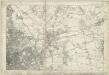
Essex LXXIII - OS Six-Inch Map
1 : 10560 Topographic maps Ordnance Survey Ordnance Survey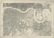
Kent I - OS Six-Inch Map
1 : 10560 Topographic maps Ordnance Survey Ordnance Survey
TQ48 - OS 1:25,000 Provisional Series Map
1 : 25000 Topographic maps Ordnance Survey Ordnance Survey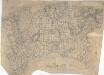
Dagenham
1 : 21120 This rough field sketch, or 'foul' copy, was produced on several pieces of irregularly cut paper joined together and laid on the verso of the triangulation map for southern England. Covering the north side of the Thames, East Ham and Ilford are to the left, and Rainham to the right. The drawing is dominated by a patchwork of field boundaries, with open dotting indicating unproductive enclosed land. The detail recorded here was incorporated in the 'fair' map OSD 132, titled 'Barking'.
Barking, Essex
1 : 21120 This plan of the north side of the Thames shows Barking and Ilford to the left, on the banks of the Roding, and Rainhham and Hornchurch to the right. A patchwork of field boundaries dominate the landscape, with open dotting depicting unproductive enclosed land. Pencil lines intersect across the plan, recording the angular measurements taken by the surveyor to calculate the distances between fixed points in the landscape.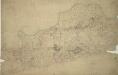
Woolwich
1 : 21120 This drawing covers the south bank of the River Thames from Deptford to Erith. Pencil and red ink rays extending from fixed points are clearly visible on the manuscript, and were used to plot the survey of the area. The numbers 1 to 7 in red ink across the map indicate the position from which field sketches were taken. Buildings are infilled and blocked in red at settlements like Woolwich and Greenwich. Clearly indicated is the Woolwich Warren, site of naval shipbuilding since the early-16th century. Before the Royal Arsenal was officially established there in 1805, the Warren had been home of military armsworks for more than a century.
Kaart van Londen enz. en van het naby gelegen land ruim een uur gaans rondom dezelve stad : getrokken uit de groote gemeeten kaart van de Hr. John Rocque
1 : 63500 Amstersdam : Isaak Tirion
The fourth sheet of an actual survey of the county of Middlesex in which the parishes within the bills of mortality are bounded with red to be distinguished from the others
1 Blatt : 53 x 70 cm John Rocque