Maps of Redbridge
Essex (1st Ed/Rev 1862-96) LXV.8 (includes: Buckhurst Hill; Chigwell; Ilford; Woodford) - 25 Inch Map
1 : 2500 Topographic maps Ordnance Survey Ordnance Survey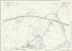
Essex (New Series 1913-) n LXIX.15 (includes: Buckhurst Hill; Chigwell) - 25 Inch Map
1 : 2500 Topographic maps Ordnance Survey Ordnance Survey
Essex (New Series 1913-) n LXXVIII.3 (includes: Chigwell; Ilford; Woodford) - 25 Inch Map
1 : 2500 Topographic maps Ordnance Survey Ordnance Survey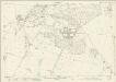
Essex (New Series 1913-) n LXXVIII.3 (includes: Chigwell; Ilford; Woodford) - 25 Inch Map
1 : 2500 Topographic maps Ordnance Survey Ordnance Survey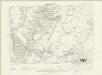
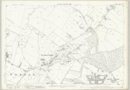
Essex LXV.NE - OS Six-Inch Map
1 : 10560 Topographic maps Ordnance Survey Ordnance Survey
Essex nLXIX.SE - OS Six-Inch Map
1 : 10560 Topographic maps Ordnance Survey Ordnance Survey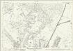
Essex (New Series 1913-) n LXIX.14 (includes: Buckhurst Hill; Woodford) - 25 Inch Map
1 : 2500 Topographic maps Ordnance Survey Ordnance Survey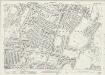
Essex (New Series 1913-) n LXXVIII.2 (includes: Woodford) - 25 Inch Map
1 : 2500 Topographic maps Ordnance Survey Ordnance Survey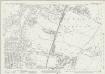
Essex (New Series 1913-) n LXXVIII.2 (includes: Woodford) - 25 Inch Map
1 : 2500 Topographic maps Ordnance Survey Ordnance Survey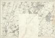
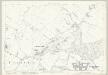
Essex LXV - OS Six-Inch Map
1 : 10560 Topographic maps Ordnance Survey Ordnance Survey
TQ49 - OS 1:25,000 Provisional Series Map
1 : 25000 Topographic maps Ordnance Survey Ordnance Survey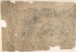
Enfield
Triangulation lines radiating from fixed points are clearly visible on this map. A pecked red line running adjacent to Lee River marks the boundary separating Essex from Hertforshire and Middlesex. Henhault Forest is shown by a stippled canopy of tree tops at the centre of the drawing. Perhaps the most interesting detail on this map is just south of the forest: a small drawing of a tree inside an enclosure marked 'Fairlop Oak'. This giant oak tree was something of a local landmark. In 1791, William Forsyth, gardener to George III, made unsuccessful attempts to halt the tree's decline. The year that this map was published, the tree was badly burnt by a fire started during a picnic. Its health steadily continued to wane until it was blown down in a gale in 1820. The inclusion of details such as the Fairlop Oak reveals the meticulous nature of the Survey, and the great attention paid to local detail. Budgen, Charles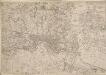
Map of the County of Middlesex in which parishes are bounded with red to be distinguished from the others
The title is missing from this copy of the map. The gives a list of parishes within the Bill of Mortality in scroll at top right with parish boundaries outlined in colour. Land use and reliefs are expressed by symbols, with the built-up area within the City of London represented by stippling. Rocque, John
Ordnance Survey of England. Sheet 257, Romford
1 : 63360 Ordnance survey. GB Southampton : Ordnance Survey Office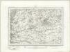
Romford (Outline) - OS One-Inch Revised New Series
1 : 63360 Topographic maps Ordnance Survey Ordnance Survey
Romford (Hills) - OS One-Inch Revised New Series
1 : 63360 Topographic maps Ordnance Survey Ordnance Survey
Map of the New River from its Source near the Town of Ware to London
Map of the course of the New River, a man made water course which has supplied London with fresh water from Hertfordshire since 1613. Commissioned by the House of Commons, the map features title and scale bar at top right and key to colour at bottom right. Telford, Thomas
London.
1 : 95000 Colton, G.W.
Environs of London.
Colton, G.W.
London and its environs : containing the boundaries of the metropolitan boroughs, the different railroads & stations, the new cemeteries, roads, docks, canals, and all the modern improvements : this map is chiefly from the Ordinance Survey, the railroads and other improvements are from the official copies, the boroughs of Marylebone from the survey published by M.r Britton, the whole corrected from personal observation & measurement
1 : 42000 Davies, Benjamin Rees C. F. Cheffins, lithog ; Wm. S. Orr & Co. ; Letts & Son ; J. Cross & Son ; T.W. Saunders
London, England.
1 : 1500000 Colton, G.W.
Die Environs von LONDON
Londýn (Anglie)
Die Environs von London
Londýn (Anglie) Landes Industrie Comptoirs
Environs of London.
1 : 95000 Colton, G.W.
How to travel in and around London by railway
London : M. Vigers
Geological map London.
1 : 90000 Letts, Son & Co.
Orographical map London.
1 : 90000 Letts, Son & Co.
The M.P. atlas
Edinburgh : W. & A.K. Johnston,
London passenger transport map
Ordnance Survey