Maps of Camden
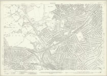
London (1915- Numbered sheets) II.13 (includes: Islington; St Pancras) - 25 Inch Map
1 : 2500 Topographic maps Ordnance Survey Ordnance Survey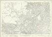
London (1915- Numbered sheets) II.13 (includes: Islington; St Pancras) - 25 Inch Map
1 : 2500 Topographic maps Ordnance Survey Ordnance Survey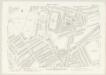
London III.82 - OS London Town Plan
1 : 1056 Topographic maps Ordnance Survey Ordnance Survey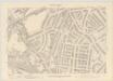
London III.92 - OS London Town Plan
1 : 1056 Topographic maps Ordnance Survey Ordnance Survey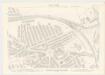
London III.91 - OS London Town Plan
1 : 1056 Topographic maps Ordnance Survey Ordnance Survey
London III.81 - OS London Town Plan
1 : 1056 Topographic maps Ordnance Survey Ordnance Survey
Insurance Plan of London North West District Vol. C: sheet 18-2
1 : 480 This detailed 1901 plan of London is one of a series of four sheets in an atlas originally produced to aid insurance companies in assessing fire risks. The building footprints, their use (commercial, residential, educational, etc.), the number of floors and the height of the building, as well as construction materials (and thus risk of burning) and special fire hazards (chemicals, kilns, ovens) were documented in order to estimate premiums. Names of individual businesses, property lines, and addresses were also often recorded. Together these maps provide a rich historical shapshot of the commercial activity and urban landscape of towns and cities at the time. The British Library holds a comprehensive collection of fire insurance plans produced by the London-based firm Charles E. Goad Ltd. dating back to 1885. These plans were made for most important towns and cities of the British Isles at the scales of 1:480 (1 inch to 40 feet), as well as many foreign towns at 1:600 (1 inch to 50 feet). Chas E Goad Limited Chas E Goad Limited
Insurance Plan of London North West District Vol. C: sheet 23-2
1 : 480 This detailed 1900 plan of London is one of a series of thirteen sheets in an atlas originally produced to aid insurance companies in assessing fire risks. The building footprints, their use (commercial, residential, educational, etc.), the number of floors and the height of the building, as well as construction materials (and thus risk of burning) and special fire hazards (chemicals, kilns, ovens) were documented in order to estimate premiums. Names of individual businesses, property lines, and addresses were also often recorded. Together these maps provide a rich historical shapshot of the commercial activity and urban landscape of towns and cities at the time. The British Library holds a comprehensive collection of fire insurance plans produced by the London-based firm Charles E. Goad Ltd. dating back to 1885. These plans were made for most important towns and cities of the British Isles at the scales of 1:480 (1 inch to 40 feet), as well as many foreign towns at 1:600 (1 inch to 50 feet). Chas E Goad Limited Chas E Goad Limited
Insurance Plan of London North West District Vol. C: sheet 19-1
1 : 480 This detailed 1901 plan of London is one of a series of four sheets in an atlas originally produced to aid insurance companies in assessing fire risks. The building footprints, their use (commercial, residential, educational, etc.), the number of floors and the height of the building, as well as construction materials (and thus risk of burning) and special fire hazards (chemicals, kilns, ovens) were documented in order to estimate premiums. Names of individual businesses, property lines, and addresses were also often recorded. Together these maps provide a rich historical shapshot of the commercial activity and urban landscape of towns and cities at the time. The British Library holds a comprehensive collection of fire insurance plans produced by the London-based firm Charles E. Goad Ltd. dating back to 1885. These plans were made for most important towns and cities of the British Isles at the scales of 1:480 (1 inch to 40 feet), as well as many foreign towns at 1:600 (1 inch to 50 feet). Chas E Goad Limited Chas E Goad Limited
Insurance Plan of London North West District Vol. C: sheet 18-1
1 : 480 This detailed 1901 plan of London is one of a series of four sheets in an atlas originally produced to aid insurance companies in assessing fire risks. The building footprints, their use (commercial, residential, educational, etc.), the number of floors and the height of the building, as well as construction materials (and thus risk of burning) and special fire hazards (chemicals, kilns, ovens) were documented in order to estimate premiums. Names of individual businesses, property lines, and addresses were also often recorded. Together these maps provide a rich historical shapshot of the commercial activity and urban landscape of towns and cities at the time. The British Library holds a comprehensive collection of fire insurance plans produced by the London-based firm Charles E. Goad Ltd. dating back to 1885. These plans were made for most important towns and cities of the British Isles at the scales of 1:480 (1 inch to 40 feet), as well as many foreign towns at 1:600 (1 inch to 50 feet). Chas E Goad Limited Chas E Goad Limited
PLAN OF THE HAMLET OF KENTISH TOWN and its VICINITY 45 A
1 : 4572 The title and compass of this plan feature at top right, with scale bar and key at bottom right. The boundaries of the Gloucester Palace District and Holmes Estate are outlined in red and green respectively. The development of Kentish Town as a predominantly middle-class residential suburb began in the 1840s and the area lost the rural charm that had, along with its many inns and public houses, made it a popular destination for day trips from London.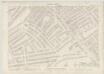
London III.83 - OS London Town Plan
1 : 1056 Topographic maps Ordnance Survey Ordnance Survey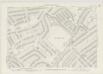
London III.93 - OS London Town Plan
1 : 1056 Topographic maps Ordnance Survey Ordnance Survey
London III.71 - OS London Town Plan
1 : 1056 Topographic maps Ordnance Survey Ordnance Survey
London III.72 - OS London Town Plan
1 : 1056 Topographic maps Ordnance Survey Ordnance Survey
PLAN OF THE HAVERSTOCK HILL AND KENTISH TOWN ESTATE, being a portion of the FREEHOLD GROUND RENTS OF THE LORD SOUTHAMPTON
1 : 1968 The development of Kentish Town as a predominantly middle-class residential suburb began in the 1840s. This plan of the Haverstock Hill and Kentish Town Estates was produced for the sale at auction of Lord Southampton's estate in 1840. The plan features title at top right, compass at top left, and scale bar at bottom left, with individual lots numbered for reference. Madeley
Insurance Plan of London North West District Vol. C: sheet 17
1 : 480 This detailed 1901 plan of London is one of a series of four sheets in an atlas originally produced to aid insurance companies in assessing fire risks. The building footprints, their use (commercial, residential, educational, etc.), the number of floors and the height of the building, as well as construction materials (and thus risk of burning) and special fire hazards (chemicals, kilns, ovens) were documented in order to estimate premiums. Names of individual businesses, property lines, and addresses were also often recorded. Together these maps provide a rich historical shapshot of the commercial activity and urban landscape of towns and cities at the time. The British Library holds a comprehensive collection of fire insurance plans produced by the London-based firm Charles E. Goad Ltd. dating back to 1885. These plans were made for most important towns and cities of the British Isles at the scales of 1:480 (1 inch to 40 feet), as well as many foreign towns at 1:600 (1 inch to 50 feet). Chas E Goad Limited Chas E Goad Limited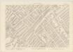
London III.73 - OS London Town Plan
1 : 1056 Topographic maps Ordnance Survey Ordnance Survey
Insurance Plan of London North West District Vol. C: sheet 19-2
1 : 480 This detailed 1901 plan of London is one of a series of four sheets in an atlas originally produced to aid insurance companies in assessing fire risks. The building footprints, their use (commercial, residential, educational, etc.), the number of floors and the height of the building, as well as construction materials (and thus risk of burning) and special fire hazards (chemicals, kilns, ovens) were documented in order to estimate premiums. Names of individual businesses, property lines, and addresses were also often recorded. Together these maps provide a rich historical shapshot of the commercial activity and urban landscape of towns and cities at the time. The British Library holds a comprehensive collection of fire insurance plans produced by the London-based firm Charles E. Goad Ltd. dating back to 1885. These plans were made for most important towns and cities of the British Isles at the scales of 1:480 (1 inch to 40 feet), as well as many foreign towns at 1:600 (1 inch to 50 feet). Chas E Goad Limited Chas E Goad Limited
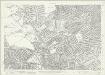
Insurance Plan of London West North-West District Vol. B: Key Plan
1 : 3600 This "key plan" indicates coverage of the Goad 1902 series of fire insurance maps of London that were originally produced to aid insurance companies in assessing fire risks. The building footprints, their use (commercial, residential, educational, etc.), the number of floors and the height of the building, as well as construction materials (and thus risk of burning) and special fire hazards (chemicals, kilns, ovens) were documented in order to estimate premiums. Names of individual businesses, property lines, and addresses were also often recorded. Together these maps provide a rich historical shapshot of the commercial activity and urban landscape of towns and cities at the time. The British Library holds a comprehensive collection of fire insurance plans produced by the London-based firm Charles E. Goad Ltd. dating back to 1885. These plans were made for most important towns and cities of the British Isles at the scales of 1:480 (1 inch to 40 feet), as well as many foreign towns at 1:600 (1 inch to 50 feet). Chas E Goad Limited Chas E Goad Limited
Essex nLXXVII - OS Six-Inch Map
1 : 10560 Topographic maps Ordnance Survey Ordnance Survey
London Sheet G - OS Six-Inch Map
1 : 10560 Topographic maps Ordnance Survey Ordnance Survey
Middlesex XII - OS Six-Inch Map
1 : 10560 Topographic maps Ordnance Survey Ordnance Survey
A Survey of the Roads and Foot-paths in the Parish of ISLINGTON. From a plan in the Vestry Room, Drawn in the Year 1735
1 : 14400 This is a plan of footpaths and roads in the parish of Islington. It extends from Battle Bridge to Highgate and from ''Cruch End'' to Kings Land and the boundary to Shoreditch. An interesting feature on this map is Jack Straws House near Highbury. Jack Straw was a leader of one band of rebels who attacked the Treasurer's House at Highbury on June 14, 1381. The Peasants' Revolt over increasing taxation was largely due to the monarchy's prosectution of war against France. Toll gates are also marked in various places. Hawsworth, J.
PLAN of the Parish of St. Mary. Islington
This is a plan of the parish of St Mary's, Islington, with three vignettes depicting the Scotch Church, the New Church and St Peter's Chapel down the right of the plate. Baker, B.
Insurance Plan of London North North West District Vol. D: Key Plan
1 : 10560 This "key plan" indicates coverage of the Goad 1892 series of fire insurance maps of London that were originally produced to aid insurance companies in assessing fire risks. The building footprints, their use (commercial, residential, educational, etc.), the number of floors and the height of the building, as well as construction materials (and thus risk of burning) and special fire hazards (chemicals, kilns, ovens) were documented in order to estimate premiums. Names of individual businesses, property lines, and addresses were also often recorded. Together these maps provide a rich historical shapshot of the commercial activity and urban landscape of towns and cities at the time. The British Library holds a comprehensive collection of fire insurance plans produced by the London-based firm Charles E. Goad Ltd. dating back to 1885. These plans were made for most important towns and cities of the British Isles at the scales of 1:480 (1 inch to 40 feet), as well as many foreign towns at 1:600 (1 inch to 50 feet). Chas E Goad Limited Chas E Goad Limited
Insurance Plan of London North District Vol. D: Key Plan
1 : 3600 This "key plan" indicates coverage of the Goad 1901 series of fire insurance maps of London that were originally produced to aid insurance companies in assessing fire risks. The building footprints, their use (commercial, residential, educational, etc.), the number of floors and the height of the building, as well as construction materials (and thus risk of burning) and special fire hazards (chemicals, kilns, ovens) were documented in order to estimate premiums. Names of individual businesses, property lines, and addresses were also often recorded. Together these maps provide a rich historical shapshot of the commercial activity and urban landscape of towns and cities at the time. The British Library holds a comprehensive collection of fire insurance plans produced by the London-based firm Charles E. Goad Ltd. dating back to 1885. These plans were made for most important towns and cities of the British Isles at the scales of 1:480 (1 inch to 40 feet), as well as many foreign towns at 1:600 (1 inch to 50 feet). Chas E Goad Limited Chas E Goad Limited
PLAN OF ISLINGTON PARISH
1 : 9744 This detailed plan of the parish of Islington records each property and field boundary and even indicates the layout of the gardens and trees. A vignette in the lower right corner shows a view of Canonbury from 1821. The note at lower left reports the increase in building over the last seven years and the population growth. Dent, R.
A Plan of te Parish of ST MARY ISLINGTON, with the boundaries of the Several Ecclesiastical Districts, Sueveyed by R. Creighton for the Parochial History, BY S. LEWIS, JUNR.
1 : 15840 Plan of the parish of St Mary's Islington, with the nine ecclesiastical districts that make up the parish delineated by pastel colours. Dower, John, Pentonville.