Maps of Flintshire
Flintshire XVII - OS Six-Inch Map
1 : 10560 Topographic maps Ordnance Survey Ordnance Survey
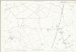
Denbighshire XXI.NE - OS Six-Inch Map
1 : 10560 Topographic maps Ordnance Survey Ordnance Survey
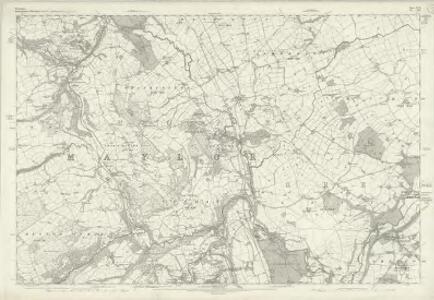
Denbighshire XXI.NE - OS Six-Inch Map
1 : 10560 Topographic maps Ordnance Survey Ordnance Survey
Denbighshire XXI.NE - OS Six-Inch Map
1 : 10560 Topographic maps Ordnance Survey Ordnance Survey
Flintshire XVII.NE - OS Six-Inch Map
1 : 10560 Topographic maps Ordnance Survey Ordnance Survey
Denbighshire XXI.SE - OS Six-Inch Map
1 : 10560 Topographic maps Ordnance Survey Ordnance Survey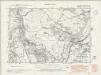
Denbighshire XXI.SE - OS Six-Inch Map
1 : 10560 Topographic maps Ordnance Survey Ordnance Survey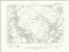
Denbighshire XXI.SE - OS Six-Inch Map
1 : 10560 Topographic maps Ordnance Survey Ordnance Survey
Flintshire XVII.SE - OS Six-Inch Map
1 : 10560 Topographic maps Ordnance Survey Ordnance Survey
Flintshire XVII.NW - OS Six-Inch Map
1 : 10560 Topographic maps Ordnance Survey Ordnance Survey
Flintshire XVII.NW - OS Six-Inch Map
1 : 10560 Topographic maps Ordnance Survey Ordnance Survey
Flintshire XVII.NW - OS Six-Inch Map
1 : 10560 Topographic maps Ordnance Survey Ordnance Survey
Denbighshire XXI.SW - OS Six-Inch Map
1 : 10560 Topographic maps Ordnance Survey Ordnance Survey
Denbighshire XXI.SW - OS Six-Inch Map
1 : 10560 Topographic maps Ordnance Survey Ordnance Survey
Flintshire XVII.SW - OS Six-Inch Map
1 : 10560 Topographic maps Ordnance Survey Ordnance Survey
Flintshire XVII.2 (includes: Hope; Mold Rural) - 25 Inch Map
1 : 2500 Topographic maps Ordnance Survey Ordnance Survey
Flintshire XVII.6 (includes: Hope; Llanfynydd) - 25 Inch Map
1 : 2500 Topographic maps Ordnance Survey Ordnance Survey
Flintshire XVII.10 (includes: Hope; Llanfynydd) - 25 Inch Map
1 : 2500 Topographic maps Ordnance Survey Ordnance Survey
Flintshire XVII.5 (includes: Hope; Llanfynydd; Treuddyn) - 25 Inch Map
1 : 2500 Topographic maps Ordnance Survey Ordnance Survey
Flintshire XVII.9 (includes: Llanfynydd; Treuddyn) - 25 Inch Map
1 : 2500 Topographic maps Ordnance Survey Ordnance Survey
Flintshire XVII.1 (includes: Hope; Llanfynydd; Mold Rural; Treuddyn) - 25 Inch Map
1 : 2500 Topographic maps Ordnance Survey Ordnance Survey
SJ35 - OS 1:25,000 Provisional Series Map
1 : 25000 Topographic maps Ordnance Survey Ordnance Survey
SJ25 - OS 1:25,000 Provisional Series Map
1 : 25000 Topographic maps Ordnance Survey Ordnance Survey
Cheshire XLV - OS Six-Inch Map
1 : 10560 Topographic maps Ordnance Survey Ordnance Survey
Cyrn y Brain
1 : 31680 The county boundary of Denbighshire and Flintshire is indicated here by a red pecked line. The plan is formally titled, with a note in the top left corner explaining that it has been copied from the original protraction with north facing upwards instead of true. A triangulation diagram appears on the reverse of the drawing: this enabled the draughtsman to plot with prominent topographical features with precision. Many pencil lines radiate from a trigonometrical point at Cefny Fedw, indicated by a dot within a triangle. These represent the angular measurements taken from this point. Giles, John C.
Flint (Outline) - OS One-Inch Revised New Series
1 : 63360 Topographic maps Ordnance Survey Ordnance Survey
Flint (Hills) - OS One-Inch Revised New Series
1 : 63360 Topographic maps Ordnance Survey Ordnance Survey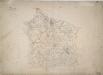
Mold
1 : 31680 A triangulation diagram appears on the reverse of this diagram, enabling the draughtsman to plot features of the landscape with precision. An area calculation is also written on the back of the sheet. At Northop, pencil lines radiate from a dot within a red triangle. This is a trigonometrical station from which angular measurements were taken. The ancient Watts Dike is named in gothic script; the standard presentation after 1816, when the inclusion of archaeological features became obligatory. A note in the bottom left of the drawing gives the date on which the drawing was received in the Tower - one of the few plans to do so. Giles, John C.
Cheshire XLVI.13 (includes: Allington; Burton; Pulford) - 25 Inch Map
1 : 2500 Topographic maps Ordnance Survey Ordnance Survey