Maps of Westminster
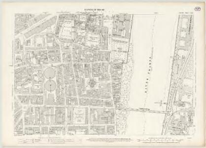
London VII.93 - OS London Town Plan
1 : 1056 Topographic maps Ordnance Survey Ordnance Survey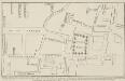
Dean Yard [A Plan of], taken in the year 1734 & 1748.
This is a retrospective plan made from an earlier drawing. It shows the buildings that once covered the southern half of Deans Yard. Among these are the Quaker Meeting House, the Quaker School, the Little Almonry and the Alms Houses. Smith, John Thomas
Insurance Plan of London Western District Vol. A: sheet 38-3
1 : 480 This detailed 1901 plan of London is one of a series of forty-one sheets in an atlas originally produced to aid insurance companies in assessing fire risks. The building footprints, their use (commercial, residential, educational, etc.), the number of floors and the height of the building, as well as construction materials (and thus risk of burning) and special fire hazards (chemicals, kilns, ovens) were documented in order to estimate premiums. Names of individual businesses, property lines, and addresses were also often recorded. Together these maps provide a rich historical shapshot of the commercial activity and urban landscape of towns and cities at the time. The British Library holds a comprehensive collection of fire insurance plans produced by the London-based firm Charles E. Goad Ltd. dating back to 1885. These plans were made for most important towns and cities of the British Isles at the scales of 1:480 (1 inch to 40 feet), as well as many foreign towns at 1:600 (1 inch to 50 feet). Chas E Goad Limited Chas E Goad Limited
Insurance Plan of London Western District Vol. A: sheet 39-1
1 : 480 This detailed 1901 plan of London is one of a series of forty-one sheets in an atlas originally produced to aid insurance companies in assessing fire risks. The building footprints, their use (commercial, residential, educational, etc.), the number of floors and the height of the building, as well as construction materials (and thus risk of burning) and special fire hazards (chemicals, kilns, ovens) were documented in order to estimate premiums. Names of individual businesses, property lines, and addresses were also often recorded. Together these maps provide a rich historical shapshot of the commercial activity and urban landscape of towns and cities at the time. The British Library holds a comprehensive collection of fire insurance plans produced by the London-based firm Charles E. Goad Ltd. dating back to 1885. These plans were made for most important towns and cities of the British Isles at the scales of 1:480 (1 inch to 40 feet), as well as many foreign towns at 1:600 (1 inch to 50 feet). Chas E Goad Limited Chas E Goad Limited
A MAPP of the Parish of St MARGARETS Westminster taken from the last Survey with Corrections 7A
1 : 3692 This is John Strype's first edition of Stow's survey. John Stow was a retired sailor who dedicated his retirement to gathering information from records and residents of the Georgian city.The survey extended to include London and Westminster in their entirety, capturing London between Restoration and 18th-century developments.The land on Mill Bank is denoted "Marshy Ground". Renowned for its unhealthy damp atmosphere,it would become the site of the infamous Millbank Penitentiary, and later Tate Britain. Above this a "New Church" is in the process of completion. This would become St John's. Although the survey proved popular, Stow died in poverty at the age of 80, having been granted licence to beg by James I. Stow, John
The Plan of ye City of Westminster [showing five locations proposed for the placing of a new bridge]
1 : 3600 Due to the growth of the area in the 18th century, a bridge at Westminster became necessary.This plan shows suggested locations for the building of a bridge. The five locations proposed are: "A", the Horse Ferry on Millbank; "B", College Street or the Slaughter House; "C", the wool stable opposite New Place Yard; "D", Stephen's Alley; "E", Whitehall. There are evident concerns about the Whitehall location being too near the 'elbow' of the river. Cole, B.
A MAPP of the Parish of St MARGARETS Westminster taken from the last Survey with Corrections 7 B
This is John Strype's second edition of Stow's survey, published "due to Act of Parliament". This is a reference to the Copyright Act just passed in an effort to stop unauthorised copying of maps. John Stow was a retired sailor who dedicated his retirement to gathering information from records and residents of the Georgian city. The survey extended to include London and Westminster in their entirety, capturing London between Restoration and 18th-century developments. The land on Mill Bank is denoted "Marshy Ground". Renowned for its unhealthy damp atmosphere, it would become the site of the infamous Millbank Penitentiary, and later Tate Britain. Above this a "New Church" sin the process of completion. This would become St John's. Although the survey proved popular, Stow died in poverty at the age of 80,having been granted licence to beg by James I. Stow, John
A PLAN of the Lower Parts of the Parishes of ST Margaret and ST JOHN the EVANGELIST, WESTMINSTER, from the HORSE FERRY to WHITEHALL, taken from an ACTUAL SURVEY
1 : 2286 This map shows developments around Westminster Abbey and on the bank of the Thames. Lediard, T.
Manuscript] Procession of the Coronation of King George the Second and his Quee
1 : 900 This manuscript plan shows the route of the procession of George II's Coronation, from Westminster Hall to the Abbey. George II's reign was dominated by the Jacobin conflict, and his reign was threatened in 1745 by Charles Edward Stuart, the Young Pretender, who landed in Scotland. The Jacobite threat came to an end when Charles was defeated at the Battle of Culloden in April 1746.The country prospered greatly during George II's reign, with the coal and shipbuilding industries becoming more productive, an overall growth in the population, and the establishment of British control in Madras and Bengal.
A PLAN of Part of the Ancient City of WESTMINSTER
1 : 1010 In the forty years prior to the publication of this map Sir Christopher Wren had been surveyor of the area around Westminster Abbey and had undertaken restoration work, while his assistant Nicholas Hawksmoor designed the West Towers. The layout of individual piers in Westminster Abbey is shown. C. Fourdrinier & Co,
A PLAN of Part of the Ancient City of Westminster
1 : 1028 Thomas Lediard was the agent and surveyor for the Commission for Streets and Waterways.Westminster bridge, the first major bridge to be built across the Thames since the medieval London Bridge, is marked as "New Bridge".The expansion of Westminster in the 18th century necessitated an alternative to the timber Putney Bridge, the only river crossing west of the City.The grey blocks featured on this map are new buildings on the new streets near the approach to Westminster Bridge. Thomas Lediard Esq
Report from Commissioners under 46 Geo III. For Improvements in Westminster.
This plan was ordered by the House of Commons, showing the property that needed to be bought and demolished to make way for the improvements at Westminster Bridge. The watermen who were made largely redundant by this new structure were paid 163;25,000 in compensation. Basire, J.
A Groundplot of part of the Citty of WESTMINSTER [Showing the route of the Procession from the Hall to the Abbey of the Coronation of James II 23rd of April 1685]
1 : 912 The route of the Coronation of King James II in 1685 was lined with His Majesty's Troop of Horses and Regiments of Footguards, represented on this map by groups of circles. At the time there were standing armies of nearly 20,000 men in British kingdoms. The procession moved from Westminster Hall to Westminster Abbey. James converted to Catholicism in 1669, but despite this he succeeded to the throne peacefully at the age of 51. Aiming for religious toleration, James issued the Declaration of Indulgence in 1687. The following year his son, James Stuart, was born to his second wife, the Catholic Mary of Modena, arousing fear that a Roman Catholic dynasty would be established. The Protestant husband of James's elder daughter, William of Orange, invaded on 5 November 1688 and the army and the navy rallied to William, precipitating James' escape to France. James was defeated at the Battle of the Boyne, in Ireland, when he tried to reclaim the throne in 1690. He spent the rest of his life in exile in France, dying there in 1701.
FOUNDATION PLAN of the ANCIENT PALACE of Westminster~ Measured, Drawn & Engraved by I. T. SMITH.
1 : 2556 This annotated plan of the Palace of Westminster and the immediate surrounding land includes a plan of part of Westminster as it was in the time of Richard II. Smith, John Thomas
Insurance Plan of London Western District Vol. A: sheet 39-3
1 : 480 This detailed 1901 plan of London is one of a series of forty-one sheets in an atlas originally produced to aid insurance companies in assessing fire risks. The building footprints, their use (commercial, residential, educational, etc.), the number of floors and the height of the building, as well as construction materials (and thus risk of burning) and special fire hazards (chemicals, kilns, ovens) were documented in order to estimate premiums. Names of individual businesses, property lines, and addresses were also often recorded. Together these maps provide a rich historical shapshot of the commercial activity and urban landscape of towns and cities at the time. The British Library holds a comprehensive collection of fire insurance plans produced by the London-based firm Charles E. Goad Ltd. dating back to 1885. These plans were made for most important towns and cities of the British Isles at the scales of 1:480 (1 inch to 40 feet), as well as many foreign towns at 1:600 (1 inch to 50 feet). Chas E Goad Limited Chas E Goad Limited
Insurance Plan of London Western District Vol. A: sheet 38-1
1 : 480 This detailed 1901 plan of London is one of a series of forty-one sheets in an atlas originally produced to aid insurance companies in assessing fire risks. The building footprints, their use (commercial, residential, educational, etc.), the number of floors and the height of the building, as well as construction materials (and thus risk of burning) and special fire hazards (chemicals, kilns, ovens) were documented in order to estimate premiums. Names of individual businesses, property lines, and addresses were also often recorded. Together these maps provide a rich historical shapshot of the commercial activity and urban landscape of towns and cities at the time. The British Library holds a comprehensive collection of fire insurance plans produced by the London-based firm Charles E. Goad Ltd. dating back to 1885. These plans were made for most important towns and cities of the British Isles at the scales of 1:480 (1 inch to 40 feet), as well as many foreign towns at 1:600 (1 inch to 50 feet). Chas E Goad Limited Chas E Goad Limited
Insurance Plan of London Western District Vol. A: sheet 6-2
1 : 480 This detailed 1901 plan of London is one of a series of forty-one sheets in an atlas originally produced to aid insurance companies in assessing fire risks. The building footprints, their use (commercial, residential, educational, etc.), the number of floors and the height of the building, as well as construction materials (and thus risk of burning) and special fire hazards (chemicals, kilns, ovens) were documented in order to estimate premiums. Names of individual businesses, property lines, and addresses were also often recorded. Together these maps provide a rich historical shapshot of the commercial activity and urban landscape of towns and cities at the time. The British Library holds a comprehensive collection of fire insurance plans produced by the London-based firm Charles E. Goad Ltd. dating back to 1885. These plans were made for most important towns and cities of the British Isles at the scales of 1:480 (1 inch to 40 feet), as well as many foreign towns at 1:600 (1 inch to 50 feet). Chas E Goad Limited Chas E Goad Limited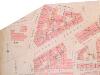
Insurance Plan of London West Vol. A: sheet 6-2
1 : 480 This detailed 1891 plan of London is one of a series of fourteen sheets in an atlas originally produced to aid insurance companies in assessing fire risks. The building footprints, their use (commercial, residential, educational, etc.), the number of floors and the height of the building, as well as construction materials (and thus risk of burning) and special fire hazards (chemicals, kilns, ovens) were documented in order to estimate premiums. Names of individual businesses, property lines, and addresses were also often recorded. Together these maps provide a rich historical shapshot of the commercial activity and urban landscape of towns and cities at the time. The British Library holds a comprehensive collection of fire insurance plans produced by the London-based firm Charles E. Goad Ltd. dating back to 1885. These plans were made for most important towns and cities of the British Isles at the scales of 1:480 (1 inch to 40 feet), as well as many foreign towns at 1:600 (1 inch to 50 feet). Chas E Goad Limited Chas E Goad Limited
Insurance Plan of London Western District Vol. A: sheet 7
1 : 480 This detailed 1901 plan of London is one of a series of forty-one sheets in an atlas originally produced to aid insurance companies in assessing fire risks. The building footprints, their use (commercial, residential, educational, etc.), the number of floors and the height of the building, as well as construction materials (and thus risk of burning) and special fire hazards (chemicals, kilns, ovens) were documented in order to estimate premiums. Names of individual businesses, property lines, and addresses were also often recorded. Together these maps provide a rich historical shapshot of the commercial activity and urban landscape of towns and cities at the time. The British Library holds a comprehensive collection of fire insurance plans produced by the London-based firm Charles E. Goad Ltd. dating back to 1885. These plans were made for most important towns and cities of the British Isles at the scales of 1:480 (1 inch to 40 feet), as well as many foreign towns at 1:600 (1 inch to 50 feet). Chas E Goad Limited Chas E Goad Limited
Insurance Plan of London West Vol. A: sheet 7
1 : 480 This detailed 1891 plan of London is one of a series of fourteen sheets in an atlas originally produced to aid insurance companies in assessing fire risks. The building footprints, their use (commercial, residential, educational, etc.), the number of floors and the height of the building, as well as construction materials (and thus risk of burning) and special fire hazards (chemicals, kilns, ovens) were documented in order to estimate premiums. Names of individual businesses, property lines, and addresses were also often recorded. Together these maps provide a rich historical shapshot of the commercial activity and urban landscape of towns and cities at the time. The British Library holds a comprehensive collection of fire insurance plans produced by the London-based firm Charles E. Goad Ltd. dating back to 1885. These plans were made for most important towns and cities of the British Isles at the scales of 1:480 (1 inch to 40 feet), as well as many foreign towns at 1:600 (1 inch to 50 feet). Chas E Goad Limited Chas E Goad Limited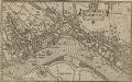
WESTMINSTER
This plan-view of Westminster was published in Norden's 'Speculum Britanniae' in 1593. The title appears at top right below the royal arms, with a compass rose at the foot of the plate. Under different jurisdiction than the City of London, Westminster had developed during the middle ages into a centre of royal administration. Along the Strand are the former residences of the Bishops deposed at the Reformation. By the late 16th Century, these properties were in the hands of the Queen's courtiers, statesmen and other people of influence. Norden, John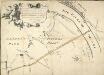
Plan of the Road through Westminster and Tutthill Fields & from St. James's Park Gate by Buckingham House & from Hyde Park Corner to a Bridge that is desired to be made over the Thames 1768 27
This engraved plan shows the road through Tutthill Fields in Westminster leading to the new bridge at Vauxhall.The plan's title features in banner at top left, with compass star at bottom right.The proposed new road stippled and highlighted in colour.
PLAN OF an ESTATE SITUATE AT MILLBANK WESTMINSTER belonging to THE MARQUIS OF SALISBURY.
1 : 1440 South of Tothill Fields lies the estate of The Marquis of Salisbury.The estate had about 30 tenants, each of whom are recorded in a reference list in the top right hand corner.This plan has been copied from an original in the possession of the Commission for Woods and Forests. Land use is indicated by various shades of green and stippling.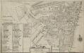
Plan of the Parish of St. Margaret, Westminster From Lea & Morden's Map
1 : 6336 The Abbey, Manchester House and the parish church are shown in elevation. The Decoy in St James' Park is shown. Robert Lea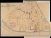
A PLAN of the Streets in the united Parishes of ST. MARGARET & ST. JOHN THE EVANGELIST, Westminster. From a Survey made by I.H. Taylor. No. 22 PARLIAMENT STREET 1828.
Plan of the parishes of St Margaret's, outlined in blue line, and St James', delineated in pink, Westminster. A thin red line shows the boundary of the Tothill Fields District. The large 6-petal structure depicted at lower left is Millbank Penitentiary, built in response to requests for prison reform and finally completed in 1821. Taylor, J. H.
A Copy of Part of a Map of London from Newcourt
This is a copy of part of the Faithorne map. It is an example of a bird's-eye (or 'plan') view. Crace often had copies made of maps if he was unable to procure an original.
Drawn plan of the Goring Estate] 3
This is a copy by Crace of a plam of the Goring Estate as it was in 1640. The drawing shows the site in Mulberry Garden Fields where Buckingham Palace was built. Crace, Frederick
Plan of Lands in the vicinity of the River Thames between Pimlico, Chelsea Hospital and the Penitentiary at Millbank.
1 : 3192 This plan of the parishes of Chelsea and St George, Hanover Square, shows the reservoirs of the Chelsea Water Company and the Ranelagh and Scholars Pond sewers. The note at lower left explains that the drawing is taken from the general plan of the district's sewers made by Peter Potter in 1815. Also shown in the plan are the Ranelagh Gardens, near Chelsea Hospital, which was last licensed as a place of public resort in 1804. Nelson, J.
Plan of the Esate belonging to Lord Grosvenor
This plan of Pimlico shows the reservoirs of the Chelsea Water Company, the Ranelagh and Scholars Pond sewers and the proposed new buildings and street layout.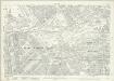
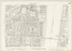
London (1915- Numbered sheets) V.13 (includes: City Of Westminster) - 25 Inch Map
1 : 2500 Topographic maps Ordnance Survey Ordnance Survey
London (Edition of 1894-96) LXXV (includes: City Of Westminster) - 25 Inch Map
1 : 2500 Topographic maps Ordnance Survey Ordnance Survey