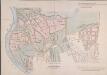
Maps of Kensington and Chelsea
London VII.71 - OS London Town Plan
1 : 1056 Topographic maps Ordnance Survey Ordnance Survey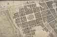
A Plan of the Cities of London and Westminster, and Borough of Southwark; with the contiguous buildings; from an actual survey, taken by John Rocque, Land-Surveyor, and engraved by John Pine
John Pine and John Tinney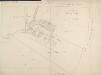
Drawn plan of the estate of Lord Berkley
1 : 768 This plan of Lord Berkley's Estate north of Piccadilly is based on a survey by Haynes in 1767. The plan shows the land from Tyburn Lane to Burlington House, including the Shoulder-of-Mutton Field, Audley Field and Great Brook Field, where the original May Fair was held. The plan also shows the new houses along Curzon Street. Haynes, John
Drawn Plan of King Scholar's Sewer
1 : 1200 This tracing of the King Scholar's sewer in Mayfairis based on a survey carried out by the Commissioners of Sewers. The plan features a scale bar down the right side of the sheet, with boundaries of private properties outlined in red. Open spaces are depicted in green and watercourses in blue.
A SURVEY OF THE CONDUITS &c. to WHITEHALL, St.JAMES &c.
1 : 3600 This is a 19th century copy of an original 1718 plan held by the Society of Antiquaries. t details the conduits supplying water to St. James's and Whitehall from Hyde Park. Long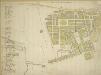
Plan of the Parish of St. George, Hanover Square
The streets of the parish are numbered in red ink for reference, with a key along the left side of the sheet.The Parish of St George was created in 1725 and covered an area previously in the Parish of St. Martin-in-the-Fields that stretched from Regent Street (then called Swallow Street) to the Serpentine, and from Oxford Street to Mayfair, Belgravia and Pimlico.
Insurance Plan of London: General Key Plan
1 : 4800 This "key plan" indicates coverage of the Goad 1889 series of fire insurance maps of London that were originally produced to aid insurance companies in assessing fire risks. The building footprints, their use (commercial, residential, educational, etc.), the number of floors and the height of the building, as well as construction materials (and thus risk of burning) and special fire hazards (chemicals, kilns, ovens) were documented in order to estimate premiums. Names of individual businesses, property lines, and addresses were also often recorded. Together these maps provide a rich historical shapshot of the commercial activity and urban landscape of towns and cities at the time. The British Library holds a comprehensive collection of fire insurance plans produced by the London-based firm Charles E. Goad Ltd. dating back to 1885. These plans were made for most important towns and cities of the British Isles at the scales of 1:480 (1 inch to 40 feet), as well as many foreign towns at 1:600 (1 inch to 50 feet). Chas E Goad Limited Chas E Goad Limited
ST. GEORGE'S PARISH, HANOVER SQUARE.
1 : 8448 This plan of the Parish of St George is surrounded by views of St George's church, Knightsbridge chapel, Conduit Street chapel, Chelsea chapel, Audley Street chapel and Berkeley chapel, the whole set within a decorative border. The title and imprint appear at the foot of the plate. The Parish of St George was created in 1725 and covered an area previously in the Parish of St. Martin-in-the-Fields that stretched from Regent Street (then called Swallow Street) to the Serpentine, and from Oxford Street to Mayfair, Belgravia and Pimlico. Bickham, J.
Insurance Plan of London: General Key Plan of North Side of River
1 : 4800 This "key plan" indicates coverage of the Goad 1889 series of fire insurance maps of London that were originally produced to aid insurance companies in assessing fire risks. The building footprints, their use (commercial, residential, educational, etc.), the number of floors and the height of the building, as well as construction materials (and thus risk of burning) and special fire hazards (chemicals, kilns, ovens) were documented in order to estimate premiums. Names of individual businesses, property lines, and addresses were also often recorded. Together these maps provide a rich historical shapshot of the commercial activity and urban landscape of towns and cities at the time. The British Library holds a comprehensive collection of fire insurance plans produced by the London-based firm Charles E. Goad Ltd. dating back to 1885. These plans were made for most important towns and cities of the British Isles at the scales of 1:480 (1 inch to 40 feet), as well as many foreign towns at 1:600 (1 inch to 50 feet). Chas E Goad Limited Chas E Goad Limited
A PLAN OF HIS MAJESTY'S BAYLIWICK OF ST. JAMES IN THE COUNTY OF MIDDLESEX
1 : 2400 This drawn survey of the West of London extends from Knightsbridge to Temple Bar and from Marylebone Gardens to Buckingham Palace. Buildings are indicated in red, open spaces and park land in green and watercourses in blue. Symbols are used to distinguish land use. Gough, William
Drawn plan of the Manor of Eybury
1 : 3192 This is a 19th-Century copy of a 1614 survey found in the records relating to the Grosvenor Estate. The plan shows the low-lying canals running from Oxford Street to the River Thames that were later used to operate the Chelsea Waterworks. Saunders, G.
HYDE PARK
1 : 3960 The title and compass star of this plan appear at middle left, with them scale bar at bottom right. At over 340 acres the largest of all the royal parks, Hyde Park was originally a hunting ground for deer, boars and wild bull. Bequeathed to the monks of Westminster after the conquest of Geoffrey de Mandeville in the 1140s, the park was appropriated by Henry VIII at the dissolution of the monasteries in 1536. The park was opened to the public at the beginning of the 17th century, and remained a deer hunting ground until 1768. Bennett, S.
PLAN OF HYDE PARK as it was in 1725
1 : 792 This retrospective plan of Hyde Park was produced from an earlier plan held in the Vestry Room in St George's Church, Hanover Square. Its title features at top right, with the scale bar at top left. At over 340 acres of land the largest of all the royal parks, Hyde Park was originally a hunting ground for deer, boars and wild bull. Bequeathed to the monks of Westminster after the conquest of Geoffrey de Mandeville in the 1140s, the park was appropriated by Henry VIII at the dissolution of the monasteries in 1536. The park was opened to the public at the beginning of the 17th century, and remained a deer hunting ground until 1768. Neele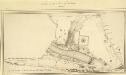
MILITARY SKETCH OF HYDE PARK
This plan shows the barracks along Knightsbridge erected for the Horse Guard at the end of the 18th century. The title appears at lower left, below the scale bar. At over 340 acres the largest of the royal parks, Hyde Park was originally a hunting ground for deer, boars and wild bull. Bequeathed to the monks of Westminster after the conquest of Geoffrey de Mandeville in the 1140s, the park was appropriated by Henry VIII at the dissolution of the monasteries in 1536. The park was opened to e public at the beginning of the 17th century and remained a deer-hunting ground until 1768. Baker, B.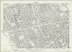
London (1915- Numbered sheets) V.9 (includes: City Of Westminster; St Marylebone; St Pancras) - 25 Inch Map
1 : 2500 Topographic maps Ordnance Survey Ordnance Survey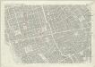
London (First Editions c1850s) XXXIV (includes: City Of Westminster; St Marylebone; St Pancras) - 25 Inch Map
1 : 2500 Topographic maps Ordnance Survey Ordnance Survey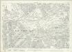
London (1915- Numbered sheets) V.13 (includes: City Of Westminster) - 25 Inch Map
1 : 2500 Topographic maps Ordnance Survey Ordnance Survey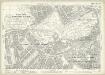
London (Edition of 1894-96) LXXV (includes: City Of Westminster) - 25 Inch Map
1 : 2500 Topographic maps Ordnance Survey Ordnance Survey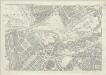
London (First Editions c1850s) XLIII (includes: City Of Westminster) - 25 Inch Map
1 : 2500 Topographic maps Ordnance Survey Ordnance Survey
Insurance Plan of London Vol. IX: Key Plan
1 : 480 This "key plan" indicates coverage of the Goad 1889 series of fire insurance maps of London that were originally produced to aid insurance companies in assessing fire risks. The building footprints, their use (commercial, residential, educational, etc.), the number of floors and the height of the building, as well as construction materials (and thus risk of burning) and special fire hazards (chemicals, kilns, ovens) were documented in order to estimate premiums. Names of individual businesses, property lines, and addresses were also often recorded. Together these maps provide a rich historical shapshot of the commercial activity and urban landscape of towns and cities at the time. The British Library holds a comprehensive collection of fire insurance plans produced by the London-based firm Charles E. Goad Ltd. dating back to 1885. These plans were made for most important towns and cities of the British Isles at the scales of 1:480 (1 inch to 40 feet), as well as many foreign towns at 1:600 (1 inch to 50 feet). Chas E Goad Limited Chas E Goad Limited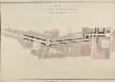
PLAN OF A NEW STREET FROM CHARING CROSS TO PORTLAND PLACE
The lack of street planning in the West End had been lamented by the architect John Gwynn in 1766 and he had suggested a plan along similar lines to the one shown here. In 1811 Portland Place would revert to the Crown, and without a new road to decrease travelling time to the city centre, profitable development of the land was unlikely. Basire, James
The Conduit Mead. The Property Belonging to the City of London
This is a 19th-Century tracing of a 1794 survey of properties belonging to the Corporation of London in New Bond Street, Conduit Street, South Molton Street and Stratford Place, Mayfair.
Drawn Plan of the Property belonging to the Crown in Park Lane and Carrington Place
1 : 480 This plan has a scale bar at bottom centre and shows the ground plans of the houses and stables in the estate, with the names of leaseholders indicated. Chawner, Thomas
PLAN of Improvement on the Crown's Estate in HAMILTON PLACE and PICCADILLY
1 : 480 The title of this plan appears at top right, with the publishers imprint and explanatory note. Houses to be built are indicated by the letter ''A''. Commissioned by the House of Commons, the plan appeared in the report of the Surveyor General of His Majesty's Land Revenue of 1805. Fordyce, John
Plan of the Houses, Stables and Gardens in Hamilton Place
1 : 480 This plan shows the renovations on the Crown's estate in Hamilton Place, Piccadilly. The plan features an explanatory note at lower left and scale bar at bottom centre. Properties in the estate appear in pink, with the stables in Hamilton Mews in pale pink. Open spaces are in green and roads in yellow. Chawner, Thomas
Map SHEWING THE IMPROVEMENTS Now in Progress at the WEST END OF LONDON
1 : 3840 The title of this plan of Hanover Square and the Parish of St George appears with the publisher's imprint at lower right. Compass star and scale bars are featured at top left. The plan shows Buckingham Palace and additions made in the Regency period to the street plan. The Parish of St. George was established in 1725 and extended from Regent Street (then called Swallow Street) to the Serpentine, and from Oxford Street to include the whole of Mayfair, Belgravia and Pimlico. Ward, E. T.
A new and exact plan of the city of London and suburbs thereof, 1
1 Blatt : 60 x 52 cm Henry Overton
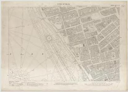
London VII.SW - OS Six-Inch Map
1 : 10560 Topographic maps Ordnance Survey Ordnance Survey
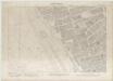
Ordnance Survey of London Skeleto
Ordnance Survey