Maps of Medway
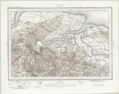
Chatham (Outline) - OS One-Inch Revised New Series
1 : 63360 Topographic maps Ordnance Survey Ordnance Survey
Chatham (Hills) - OS One-Inch Revised New Series
1 : 63360 Topographic maps Ordnance Survey Ordnance Survey
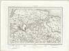
A topographical-map, of the county of Kent, 8
1 Blatt : 54 x 70 cm A. Dury, W. Herbert
A Map of the Isle of Sheppey
This map of the Isle of Sheppey dates from 1574 and is thought to be the work of the cartographer Robert Lythe.Lythewas a cartographer of note as he created the first accurate map of Ireland while under the employ of the Crown and is therefore comparable to Christopher Saxton in his importance in the context of the history of cartography. This map was created for the purposes of defence and also to solve the problem of drainage in the area. The emphasis on streams and waterways suggests a link with the repeated attempts to avoid the silting up of Sandwich Haven by increasing the amount of water it could hold. The works were to be financed by a local levy, hence perhaps the prominence of names which may be a guide to apportionment. Anglo-Spanish relations had been in steady decline since the accession of the protestant Elizabeth I in 1558. In 1574 there was a fear that the Spanish would launch an attack from the Netherlands on ships at Chatham. In the idea of transferring the main fleet to Queenborough was suggested as a precaution. Under the command of Sir William Winter, Surveyor of the Navy and Sir William Pelham, Lieutenant General of Ordnance, and Lythe a survey of Sheppey was carried out. Sheerness and the Isle of Grain were rejected in favour of a new port at Swaleness opposite Queenbrough which would prevent a raid from the rear by way of the Swale. Swaleness was a marsh and in order to build fortifications drainage and embanking or the area was necessary. This was authorised by the Privy Council in September 1574. Earthworks were created but the fortifications were not built and in the event the Spanish did not invade until 1588. Lythe, Robert
TQ87 - OS 1:25,000 Provisional Series Map
1 : 25000 Topographic maps Ordnance Survey Ordnance Survey
TQ86 - OS 1:25,000 Provisional Series Map
1 : 25000 Topographic maps Ordnance Survey Ordnance Survey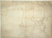
A Rough Plan of the Mouth of the River Medway
This is a rough sketch of the Mouth of the Medway. It is not dated. The fortification of Sheppy and the entrance to the river Medway was not part of the 1539 defence program, prompted by the fear of an invasion from the combined forces of France and Spain after Francis I of France, and Charles V Holy Roman Emperor and King of Spain signed a peace treaty in 1538. However, it was during Henry VIII’s reign the Medway was first used as a naval anchorage. By 1547 the approaches to the area were defended by block houses’ in addition to the medieval castle of Queenborough. Since the accession of the Protestant Elizabeth I in 1558 England’s relationship with Spain had deteriorated to the extent that Philip II wished to depose Elizabeth in favour of the Catholic Mary Stuart, Queen of Scotland, who had agreed to disinherit her protestant son (later James VI of Scotland and I of England) in favour of Philip. The fear that Spanish warships might raid from the Flemish ports in an attempt to destroy ships anchored in the river meant that the defence of the Medway was again under consideration in 1574.
TQ76 - OS 1:25,000 Provisional Series Map
1 : 25000 Topographic maps Ordnance Survey Ordnance Survey
TQ77 - OS 1:25,000 Provisional Series Map
1 : 25000 Topographic maps Ordnance Survey Ordnance Survey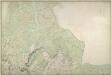
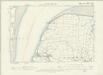
Halstow (Kent)
1 : 10560 Drawing showing the area around Halstow in Kent. This map is drawn on rectangular sheet lines, enclosed by a black border. Fields are coloured brown where cultivated, and green or blank if untilled. Marshland dominates this estuarine landscape and is depicted by symbols with three vertically inclined strokes above a short horizontal line. Stonework buildings or structures are drawn in red ink at settlements such as Iwade and Halstow at the centre of the plan. Ruled pencil rays intersect the map, evidence of angular measurements taken by the surveyor between fixed triangulation points. Altitudes ('spot heights') are measured and noted in red-ink figures.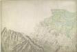
Rainham (Kent)
1 : 10560 This map of the Rainham Marshes in Kent is drawn on rectangular sheet lines, enclosed by a black border. Fields are coloured brown where cultivated, and green or blank if untilled. Stonework buildings or structures are drawn in red ink at the major settlement of Rainham, at the bottom right of the plan. Infilled or blocked areas of black or sepia ink indicate structures or buildings made from impermanent materials such as wood. Corrections have been made on this plan and the altitudes from sites of eminenece ('spot heights') are noted in red ink figures. Field boundaries are measured rather than estimated or sketched.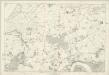
Kent XI - OS Six-Inch Map
1 : 10560 Topographic maps Ordnance Survey Ordnance Survey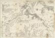
Kent XIX - OS Six-Inch Map
1 : 10560 Topographic maps Ordnance Survey Ordnance Survey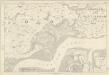
Kent XII - OS Six-Inch Map
1 : 10560 Topographic maps Ordnance Survey Ordnance Survey
Kent XX - OS Six-Inch Map
1 : 10560 Topographic maps Ordnance Survey Ordnance Survey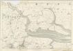
Kent XXI - OS Six-Inch Map
1 : 10560 Topographic maps Ordnance Survey Ordnance Survey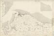
Kent XIII (inset VI) - OS Six-Inch Map
1 : 10560 Topographic maps Ordnance Survey Ordnance Survey
TQ96 - OS 1:25,000 Provisional Series Map
1 : 25000 Topographic maps Ordnance Survey Ordnance Survey
TQ97 - OS 1:25,000 Provisional Series Map
1 : 25000 Topographic maps Ordnance Survey Ordnance Survey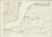
Essex nXCVI - OS Six-Inch Map
1 : 10560 Topographic maps Ordnance Survey Ordnance Survey
Lyding [Lidsing], Kent
1 : 10560 These rough pencil and ink field sketches of the North Downs in Kent were,produced on about 7 pieces of irregularly cut paper, which were then joined together and,laid down on thick card. The relief of the chalk hills is depicted by heavy,brushwork, giving the map a three-dimensional quality.
Great Britain [Second land utilisation survey] 1:25,000
Coleman, Alice Isle of Thanet Geographical Association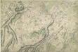
Sittingbourne, Kent
1 : 10560 This plan, showing the area around Sittingbourne in Kent, is drawn on rectangular sheet lines and enclosed by a black border. Fields are coloured brown where cultivated, and green or blank if untilled. Stonework buildings or structures are drawn in red ink at major settlements like Milton and Sittingbourne, at the centre top of the plan. Infilled or blocked areas of black or sepia ink depict structures or buildings made from impermanent materials such as wood. Corrections have been made on this plan and it is likely that the red-ink numerical annotations of altitude are measured rather than estimated or sketched.
Milton, Kent
1 : 10560 This original protraction of the Swale in Kent extends from Milton to Conyer Creek, and comprises the first plottings from the field book of the area. Ruled-black sheet lines indicate the edges of the area that were copied for the finished drawings OSD 112 and OSD 113. The plan is made up of two pieces of paper, irregularly cut and then joined together.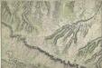
Boxley, Kent
1 : 10560 .This map, showing the area around Boxley in Kent, is drawn on rectangular sheet lines, enclosed by a black border. Fields are coloured brown where cultivated, and green or blank if untilled. Stonework buildings and structures are drawn in red ink at major settlements. Infilled or blocked areas of black or sepia ink depict structures or buildings made from less permanent materials, such as wood. Corrections have been made to this plan, and spot heights (altitudes) are clearly plotted in red-ink figures.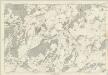
Kent XXXII - OS Six-Inch Map
1 : 10560 Topographic maps Ordnance Survey Ordnance Survey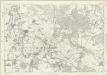
Kent XXXI - OS Six-Inch Map
1 : 10560 Topographic maps Ordnance Survey Ordnance Survey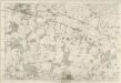
Kent XXXIII - OS Six-Inch Map
1 : 10560 Topographic maps Ordnance Survey Ordnance Survey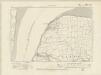
Kent IV.SW - OS Six-Inch Map
1 : 10560 Topographic maps Ordnance Survey Ordnance Survey