Maps of England
Northumberland nLXXXVI.NE - OS Six-Inch Map
1 : 10560 Topographic maps Ordnance Survey Ordnance Survey
Northumberland nLXXXVI.NE - OS Six-Inch Map
1 : 10560 Topographic maps Ordnance Survey Ordnance Survey
Northumberland nLXXXVI.NE - OS Six-Inch Map
1 : 10560 Topographic maps Ordnance Survey Ordnance Survey
Northumberland (Old Series) LXXXI.15 (includes: Seaton Valley; Whitley And Monkseaton) - 25 Inch Map
1 : 2500 Topographic maps Ordnance Survey Ordnance Survey
Northumberland (New Series) LXXXVI.4 (includes: Blyth; Whitley And Monkseaton) - 25 Inch Map
1 : 2500 Topographic maps Ordnance Survey Ordnance Survey
Northumberland (New Series) LXXXVI.4 (includes: Blyth; Whitley And Monkseaton) - 25 Inch Map
1 : 2500 Topographic maps Ordnance Survey Ordnance Survey
Northumberland (New Series) LXXXVI.8 (includes: Seaton Valley; Whitley And Monkseaton) - 25 Inch Map
1 : 2500 Topographic maps Ordnance Survey Ordnance Survey
Northumberland (New Series) LXXXVI.8 (includes: Seaton Valley; Whitley And Monkseaton) - 25 Inch Map
1 : 2500 Topographic maps Ordnance Survey Ordnance Survey
Northumberland (New Series) LXXXVI.7 (includes: Seaton Valley; Whitley And Monkseaton) - 25 Inch Map
1 : 2500 Topographic maps Ordnance Survey Ordnance Survey
Northumberland (New Series) LXXXVI.7 (includes: Seaton Valley; Whitley And Monkseaton) - 25 Inch Map
1 : 2500 Topographic maps Ordnance Survey Ordnance Survey
Northumberland (New Series) LXXXVI.3 (includes: Blyth; Seaton Valley; Whitley And Monkseaton) - 25 Inch Map
1 : 2500 Topographic maps Ordnance Survey Ordnance Survey
Northumberland (New Series) LXXXVI.3 (includes: Blyth; Seaton Valley; Whitley And Monkseaton) - 25 Inch Map
1 : 2500 Topographic maps Ordnance Survey Ordnance Survey
Northumberland (Old Series) LXXXI.14 (includes: Seaton Valley) - 25 Inch Map
1 : 2500 Topographic maps Ordnance Survey Ordnance Survey
Northumberland (Old Series) LXXXI.11 (includes: Blyth; Seaton Valley; Whitley And Monkseaton) - 25 Inch Map
1 : 2500 Topographic maps Ordnance Survey Ordnance Survey
Northumberland (Old Series) LXXXI.11 (includes: Blyth; Seaton Valley; Whitley And Monkseaton) - 25 Inch Map
1 : 2500 Topographic maps Ordnance Survey Ordnance Survey
Northumberland nLXXXVI - OS Six-Inch Map
1 : 10560 Topographic maps Ordnance Survey Ordnance Survey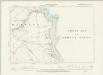
Northumberland LXXXI.SE - OS Six-Inch Map
1 : 10560 Topographic maps Ordnance Survey Ordnance Survey
Northumberland LXXXI.SW - OS Six-Inch Map
1 : 10560 Topographic maps Ordnance Survey Ordnance Survey
Northumberland (Old Series) LXXXI.10 (includes: Blyth; Seaton Valley) - 25 Inch Map
1 : 2500 Topographic maps Ordnance Survey Ordnance Survey
Northumberland (Old Series) LXXXIX.3 (includes: Seaton Valley; Whitley And Monkseaton) - 25 Inch Map
1 : 2500 Topographic maps Ordnance Survey Ordnance Survey
Northumberland (Old Series) LXXXIX.2 (includes: Seaton Valley; Whitley And Monkseaton) - 25 Inch Map
1 : 2500 Topographic maps Ordnance Survey Ordnance Survey
NZ37 & Parts of NZ38 - OS 1:25,000 Provisional Series Map
1 : 25000 Topographic maps Ordnance Survey Ordnance Survey
Northumberland LXXXI - OS Six-Inch Map
1 : 10560 Topographic maps Ordnance Survey Ordnance Survey
Northumberland LXXXIX.NE - OS Six-Inch Map
1 : 10560 Topographic maps Ordnance Survey Ordnance Survey
Northumberland LXXXIX.NW - OS Six-Inch Map
1 : 10560 Topographic maps Ordnance Survey Ordnance Survey
Northumberland (Old Series) LXXXI.16 & 12 (includes: Whitley And Monkseaton) - 25 Inch Map
1 : 2500 Topographic maps Ordnance Survey Ordnance Survey
Northumberland (Old Series) LXXXI.16 & 12 (includes: Whitley And Monkseaton) - 25 Inch Map
1 : 2500 Topographic maps Ordnance Survey Ordnance Survey
Northumberland (Old Series) LXXXIX.4 (includes: Tynemouth; Whitley And Monkseaton) - 25 Inch Map
1 : 2500 Topographic maps Ordnance Survey Ordnance Survey
The Course of River Tyne from Newcastle to Tynemouth
This is a detailed map of the course of the River Tyne from Newcastle to the mouth of Tynemouth River, it dates from around 1590. On the basis of style it can be attributed to Richard Poulter, a mariner accomplished in chart making. It is possible that Poulter’s name and the cartouche have been lost when the map was cropped. The map shows the sandbanks and sounding at low tide and notes the need for beacons to be placed on rocks which are submerged at high tide. Water depths at high tide are also indicated. The intersecting lines which cover the map are lines of constant bearing known as rhumb lines. These radiate from compass roses and allow the sailor to plot a course from harbour to harbour using dividers and straight edge. It is likely that this chart was prepared for presentation to a government official who would have power to implement the changes suggested. A possible recipient could be Lord Burghley, Elizabeth Secretary of State. Poulter, Richard
Tynemouth (Outline) - OS One-Inch Revised New Series
1 : 63360 Topographic maps Ordnance Survey Ordnance Survey