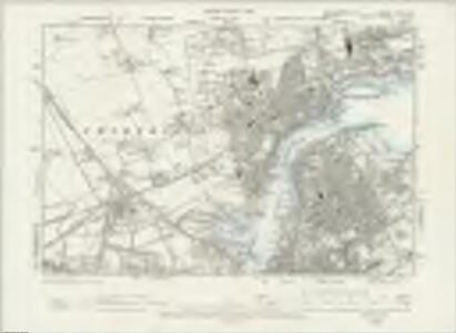
Maps of Sunderland
Northumberland LXXXIX.SE - OS Six-Inch Map
1 : 10560 Topographic maps Ordnance Survey Ordnance Survey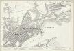
Northumberland (Old Series) LXXXIX.12 (includes: South Shields; Tynemouth) - 25 Inch Map
1 : 2500 Topographic maps Ordnance Survey Ordnance Survey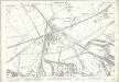
Northumberland (Old Series) LXXXIX.15 (includes: Tynemouth; Wallsend) - 25 Inch Map
1 : 2500 Topographic maps Ordnance Survey Ordnance Survey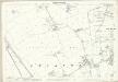
Northumberland (Old Series) LXXXIX.11 (includes: Tynemouth) - 25 Inch Map
1 : 2500 Topographic maps Ordnance Survey Ordnance Survey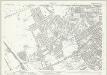
Northumberland (New Series) XCV.4 (includes: Tynemouth) - 25 Inch Map
1 : 2500 Topographic maps Ordnance Survey Ordnance Survey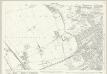
Northumberland (New Series) XCV.4 (includes: Tynemouth) - 25 Inch Map
1 : 2500 Topographic maps Ordnance Survey Ordnance Survey
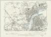
River Tyne Docks ... Albert Edward Dock (Northumberland and Tyne Docks): sheet 1~r
1 : 2400 This detailed 1921 plan of River Tyne Docks is one of a series of one sheet in an atlas originally produced to aid insurance companies in assessing fire risks. The building footprints, their use (commercial, residential, educational, etc.), the number of floors and the height of the building, as well as construction materials (and thus risk of burning) and special fire hazards (chemicals, kilns, ovens) were documented in order to estimate premiums. Names of individual businesses, property lines, and addresses were also often recorded. Together these maps provide a rich historical shapshot of the commercial activity and urban landscape of towns and cities at the time. The British Library holds a comprehensive collection of fire insurance plans produced by the London-based firm Charles E. Goad Ltd. dating back to 1885. These plans were made for most important towns and cities of the British Isles at the scales of 1:480 (1 inch to 40 feet), as well as many foreign towns at 1:600 (1 inch to 50 feet). Chas E Goad Limited Chas E Goad Limited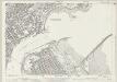
Durham IV.1 (includes: South Shields; Tynemouth) - 25 Inch Map
1 : 2500 Topographic maps Ordnance Survey Ordnance Survey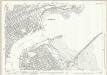
Durham IV.1 (includes: South Shields; Tynemouth) - 25 Inch Map
1 : 2500 Topographic maps Ordnance Survey Ordnance Survey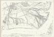
Durham III.8 (includes: Jarrow; South Shields; Tynemouth; Wallsend) - 25 Inch Map
1 : 2500 Topographic maps Ordnance Survey Ordnance Survey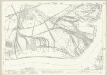
Durham III.8 (includes: Jarrow; South Shields; Tynemouth; Wallsend) - 25 Inch Map
1 : 2500 Topographic maps Ordnance Survey Ordnance Survey
River Tyne Docks ... Albert Edward Dock (Northumberland and Tyne Docks): sheet 1-2
1 : 480 This detailed 1894 plan of River Tyne Docks is one of a series of three sheets in an atlas originally produced to aid insurance companies in assessing fire risks. The building footprints, their use (commercial, residential, educational, etc.), the number of floors and the height of the building, as well as construction materials (and thus risk of burning) and special fire hazards (chemicals, kilns, ovens) were documented in order to estimate premiums. Names of individual businesses, property lines, and addresses were also often recorded. Together these maps provide a rich historical shapshot of the commercial activity and urban landscape of towns and cities at the time. The British Library holds a comprehensive collection of fire insurance plans produced by the London-based firm Charles E. Goad Ltd. dating back to 1885. These plans were made for most important towns and cities of the British Isles at the scales of 1:480 (1 inch to 40 feet), as well as many foreign towns at 1:600 (1 inch to 50 feet). Chas E Goad Limited Chas E Goad Limited
River Tyne Docks ... Albert Edward Dock (Northumberland and Tyne Docks): sheet 1-3
1 : 480 This detailed 1894 plan of River Tyne Docks is one of a series of three sheets in an atlas originally produced to aid insurance companies in assessing fire risks. The building footprints, their use (commercial, residential, educational, etc.), the number of floors and the height of the building, as well as construction materials (and thus risk of burning) and special fire hazards (chemicals, kilns, ovens) were documented in order to estimate premiums. Names of individual businesses, property lines, and addresses were also often recorded. Together these maps provide a rich historical shapshot of the commercial activity and urban landscape of towns and cities at the time. The British Library holds a comprehensive collection of fire insurance plans produced by the London-based firm Charles E. Goad Ltd. dating back to 1885. These plans were made for most important towns and cities of the British Isles at the scales of 1:480 (1 inch to 40 feet), as well as many foreign towns at 1:600 (1 inch to 50 feet). Chas E Goad Limited Chas E Goad Limited
River Tyne Docks ... Albert Edward Dock (Northumberland and Tyne Docks): sheet 1-1
1 : 480 This detailed 1894 plan of River Tyne Docks is one of a series of three sheets in an atlas originally produced to aid insurance companies in assessing fire risks. The building footprints, their use (commercial, residential, educational, etc.), the number of floors and the height of the building, as well as construction materials (and thus risk of burning) and special fire hazards (chemicals, kilns, ovens) were documented in order to estimate premiums. Names of individual businesses, property lines, and addresses were also often recorded. Together these maps provide a rich historical shapshot of the commercial activity and urban landscape of towns and cities at the time. The British Library holds a comprehensive collection of fire insurance plans produced by the London-based firm Charles E. Goad Ltd. dating back to 1885. These plans were made for most important towns and cities of the British Isles at the scales of 1:480 (1 inch to 40 feet), as well as many foreign towns at 1:600 (1 inch to 50 feet). Chas E Goad Limited Chas E Goad Limited
A Coloured Plan of Tynemouth Abbey and Castle
This is a map of Tynemouth dating from 1545. On the basis of handwriting it is thought that the cartographer was Gian Tommaso Scala, described, with Antonio da Bergamo, as 'Italians expert in fortifying' and employed by Henry VIII in the 1540’s as engineers. Tynemouth was reviewed by Sir Richard Lee in February 1545. He found it to be 'a place moste apte and nedeful to be fortyfied' 'none within this realme more'. Hostilities between England and France broke out once again in 1542 and Henry VIII was concerned about possible French plans to attack via the North as well as from Scotland. Reflecting this concern Lee was sent to survey the area with Gian Tommaso Scala and Antonio da Bergamo. This drawing and the proposals it contains may be the result of this survey. It shows two Italianate demi-bastions. These are very large and were intended to house artillery and reinforce the curtain wall which defended the west, landward, side. These proposals show the transmission of the Italian trace italienne fortification to the English. Quadrilinear in overall layout with massive angle-bastions the trace Italian fortification provided fire power outwards and flanking power along the walls so that no blind spots existed, enabling defenders to cover all the surrounding ground. Nothing like Scala’s proposal was built as there was not sufficient time to undertake anything so complex. A large ditch and a very long earth wall were built instead. Scala, Gian Tommaso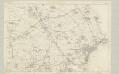
Northumberland LXXXIX - OS Six-Inch Map
1 : 10560 Topographic maps Ordnance Survey Ordnance Survey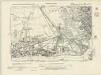
Durham III.NE - OS Six-Inch Map
1 : 10560 Topographic maps Ordnance Survey Ordnance Survey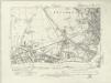
Durham III.NE - OS Six-Inch Map
1 : 10560 Topographic maps Ordnance Survey Ordnance Survey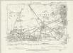
Durham III.NE - OS Six-Inch Map
1 : 10560 Topographic maps Ordnance Survey Ordnance Survey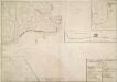
A Plan of Tinmouth Town and Castle and Clifford Fort, scituate at the Entrance of the River Tine
View of Tynemouth Castle, town and Clifford Fort with a separate small plan of Clifford Fort and section of the same fort. Tynemouth castle is situated on the cliff overlooking the River Tyne. The stone Barbican was built in the 14th century but there has been a castle on this site since the 11th century as there are records dating from 1095 detailing William Rufus’ successful capture of Earl Robert’s castle. Inside the Castle complex is Tynemouth Priory- this was once the richest priory in England and it has an impressive 22 meter high presbytery. By the 17th century the castle was a ruin and defence of the river was taken over by Clifford Fort at North Shield, which was built in 1672. The fort was built to protect the entrance to the River Tyne during the 3rd Dutch War. It was designed by a Swedish military engineer, Martin Beckman, and built by a Yorkshire architect, Robert Trollope.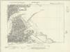
Durham IV.NW - OS Six-Inch Map
1 : 10560 Topographic maps Ordnance Survey Ordnance Survey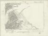
Durham IV.NW - OS Six-Inch Map
1 : 10560 Topographic maps Ordnance Survey Ordnance Survey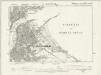
Durham IV.NW - OS Six-Inch Map
1 : 10560 Topographic maps Ordnance Survey Ordnance Survey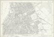
Durham IV.5 (includes: South Shields; Tynemouth) - 25 Inch Map
1 : 2500 Topographic maps Ordnance Survey Ordnance Survey
Northumberland (New Series) LXXXVI.16 (includes: Tynemouth) - 25 Inch Map
1 : 2500 Topographic maps Ordnance Survey Ordnance Survey
Northumberland (New Series) LXXXVI.16 (includes: Tynemouth) - 25 Inch Map
1 : 2500 Topographic maps Ordnance Survey Ordnance Survey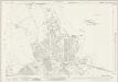
Northumberland (New Series) LXXXVII.13 & 14 (includes: Tynemouth) - 25 Inch Map
1 : 2500 Topographic maps Ordnance Survey Ordnance Survey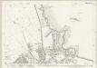
Northumberland (New Series) LXXXVII.14 (inset LXXXVII.13) (includes: Tynemouth) - 25 Inch Map
1 : 2500 Topographic maps Ordnance Survey Ordnance Survey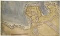
Tynemouth
This is a plan of fortifications at Tynemouth. It shows the internal structures of the fort, noting the function of each; stables, constable’s lodgings and gate house are marked. The town itself is shown in relation to the fort as a generic group of buildings, revealing that the defence fortifications are the primary concern of the draughtsman. This plan dates from 1580’s, a time of unease in England about the possibility of a Spanish invasion. The Anglo-Spanish relationship had been in steady decline since the accession of the protestant Elizabeth I. Raids on transatlantic shipping by English seamen such as Francis Drake and England’s support of the Protestant rebellion in the Spanish ruled Netherlands made matters worse and war broke out in 1585, culminating in the events of the Spanish Armada. It is recorded that on 18th March 1588, Lord Hunsdon, Governor at Berwick, informed Sir Francis Walsingham that in response to the Council’s worries about the decay of Tynemouth, he would go there with his surveyor of works, a very skilful man’ and take a perfect view’, which he would then bring to London. This plan may be the referred to perfect view’, reflecting the concern over Tynemouth’s defences in the face of the impending Spanish invasion. This plan is also interesting as it does not show two Italianate demi bastions. These were proposed to be built in plans dating from 1545. Their absence here compounds the documentary evidence that suggests that they were never built.