Maps of Sarreguemines

Le Flambeau de la Guerre Allumee au Rhin
Mollova mapová sbírka Delisle, Guillaume Schenk, Peter II
Meßtischblatt 3581 : Saar- Buckenheim, 1917
1 : 250000 Saar- Buckenheim. - Aufnahme 1882, hrsg. 1883, Auflagendr. 1917. - 1:25000. - [Berlin]: Königl. Preuss. Landesaufnahme, 1917. - 1 Kt.
Meßtischblatt 3580 : Insmingen, 1916
1 : 250000 Insmingen. - Aufn. 1882, hrsg. 1883, Aufldr. 1916. - 1:25000. - [Berlin]: Reichsamt für Landesaufnahme, 1916. - 1 Kt.
Meßtischblatt 3556 : Forbach, 1936
1 : 250000 Forbach. - Hrsg. 1883, bericht. 1929, einzelne Nachtr. 1936. - 1:25000. - Berlin: Reichsamt für Landesaufnahme, 1936. - 1 Kt.
Meßtischblatt 6808 : Saargemünd, 1940
1 : 250000 Saargemünd. - Aufn. 1881, 1912, 1933/35, hrsg. 1883, bericht. - 1:25000. - [Berlin]: Reichsamt für Landesaufnahme, 1940. - 1 Kt.
Meßtischblatt 6808 : Saargemünd, 1937
1 : 250000 Saargemünd. - Aufn. 1881, 1912, 1933/35, bericht. 1933, letzte Nachtr. 1936/37. - 1:25000. - [Berlin]: Reichsamt für Landesaufnahme, 1937. - 1 Kt.
Meßtischblatt 6909 : Rohrbach b. Bitsch, 1942
1 : 250000 Rohrbach b. Bitsch. - Hrsg. 1883, Ausg. 1942 - 1:25000. - [Berlin]: Preußische Landesaufnahme, Hauptvermessungsabt. XI, 1942. - 1 Kt.
Meßtischblatt 3558 : Bliesbrücken, 1883
1 : 250000 Bliesbrücken. - Aufn. 1881. - 1:25000. - [Berlin]: Reichsamt für Landesaufnahme, 1883. - 1 Kt.
Le Flambeau de la Guerre Allumee au Rhin
Mollova mapová sbírka Delisle, Guillaume Schenk, Peter II
Le Theatre de la Guerre Sur le Haut Rhein
1 : 142000 Mollova mapová sbírka Sanson, Guillaume
Carte Particuliere de Pays qui sont situéz entre le Rhein, la Saare, la Moselle, et la Basse Alsace
1 : 150000 Mollova mapová sbírka Jaillot, Alexis-Hubert Jaillot, Alexis Hubert
Partie Meridionale Des Pays Qui Sont Situéz Entre Le Rhein, La Saare, La Moselle Et La Basse Alsace
1 : 150000 Mollova mapová sbírka Mortier, Pieter Covens, Johannes I
Mediomatrici
1 Karte : Kupferdruck ; 43 x 50 cm Sanson chez l'auteur
Partie Meridionale Des Pays Qui Sont Situéz Entre Le Rhein, La Saare, La Moselle, Et La Basse Alsace. [Karte], in: Atlas nouveau, contenant toutes les parties du monde [...], Bd. 1, S. 241.
1 Karte aus Atlas Sanson, Nicolas Jaillot, Alexis Hubert und Mortier, Pieter
Archid.conné de Sarbovrg dans l'Evesché de Metz
1 : 240000 Mollova mapová sbírka Sanson, Nicolas Mariette, Pierre Sanson, Nicolas
[Lotrinsko a Sársko]
Lotrinsko (Francie) Buna, Wilhelm C.
Le Theatre de Bellone :
Mollova mapová sbírka Schenk, Pieter Braakman, Adriaan
Mediomatrici
1 Karte : Kupferdruck ; 44 x 51 cm Sanson; Robert de Vaugondy chez l'auteur, chés le Sr. Robert geog. ord. du roi quai de l'horloge
Carte du Duché de Lorraine, gravée sur les derniers memoires
1 : 600000 [Amsterdam] : [De La Feuille?]
Département de la Meurte
1 Karte : Kupferdruck ; 48 x 48 cm Houdan au bureau de l'atlas national rue de la Harpe no. 26, et au dépôt du dit atlas rue de la Monnoye no. 5
Alsatia inferior [Karte], in: Gerardi Mercatoris et I. Hondii Newer Atlas, oder, Grosses Weltbuch, Bd. 1, S. 244.
1 Karte aus Atlas Mercator, Gerhard und Hondius, Jodocus Jansson, Jan
Les Estats du Duc de Lorraine ou sont les Duchez de Lorraine et de Bar :
1 : 180000 Mollova mapová sbírka Jaillot, Alexis-Hubert Jaillot, Alexis Hubert

[Atlas départemental : La France et ses colonies] No. 56 Moselle
1 : 670000 publ. par Michel fils ainé [dressé par A. Lorrain, et gravé par H. Dandeleux] Versailles [etc.] : Barreswil et Andrieux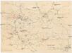
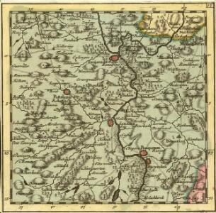
Übersichtskarte für den 15ten August Abends
1 : 200000 Francie Kgl. Hofbuchh. v. E.S. Mittler Sohn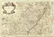
L'Alsace Divisée En Ses Principales Parties.
1 : 250000 Mollova mapová sbírka Jaillot, Alexis-Hubert Jaillot, Alexis Hubert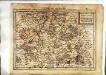
Lotharingia septentrionalis
1 Karte : Kupferdruck ; 17 x 24 cm Mercator; Keere Cloppenburgh
Alsatia tam svperior, quam inferior una cum Svndgovia
1 Karte auf 2 Blättern : Kupferdruck ; 110 x 37 cm Specklin Homännische Erben
Alsatia tam svperior, quam inferior una cum Svndgovia
1 Karte auf 2 Blatt : Kupferdruck ; 110 x 37 cm Specklin Homännische Erben
Lotharingia ducatus
1 Karte : Kupferdruck ; 35 x 46 cm Mercator; Hondius Henricus Hondius
Lotharingia ducatus
1 Karte : Kupferdruck ; 35 x 46 cm Mercator; Hondius Jodocus Hondius