Maps of Haguenau

Le Flambeau de la Guerre Allumee au Rhin
Mollova mapová sbírka Delisle, Guillaume Schenk, Peter II

Le cours du Rhin de Bâle à Hert près Philisbourg contenant l'Alsace et partie du Brisgau, 4
1 Blatt : 76 x 52 cm Le Rouge
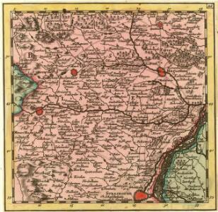
Carte über den groesten Theil des untern Elsasses, nebst der Grenze von Teutschland und Lotharingen. &c.
Bechstatt, I. C.
Topographische - Carte des Rheinstromes und seiner beiderseitigen Ufer von Hüningen bis Lauterburg...

Meßtischblatt 3618 : Schiltigheim, 1913
1 : 250000 Schiltigheim. - Aufn. 1883, hrsg. 1885, gedr. [19]13. - 1:25000. - [Berlin]: Reichsamt für Landesaufnahme, 1913. - 1 Kt.
Meßtischblatt [7312] : Kinzigmündung, 1886
1 : 250000 Kinzigmündung. - 1:25000. - Leipzig: Giesecke & Devrient, 1886. - 1 Kt.
Meßtischblatt 3617 : Truchtersheim, 1885
1 : 250000 Truchtersheim. - Aufn. 1883. - 1:25000. - [Berlin]: Reichsamt für Landesaufnahme, 1885. - 1 Kt.
Meßtischblatt [3616 = 7310] : Wasselnheim, 1884
1 : 250000 Wasselnheim. - Aufn. 1883. - 1:25000. - [Berlin]: Reichsamt für Landesaufnahme, 1884. - 1 Kt.
Meßtischblatt 3609 : Brumath, ca. 1914
1 : 250000 Brumath. - 1:25000. - [Berlin]: [Reichsamt für Landesaufnahme], ca. 1914. - 1 Kt.
Meßtischblatt 3608 : Hochfelden, 1888
1 : 250000 Hochfelden. - Aufn. 1886. - 1:25000. - [Berlin]: Reichsamt für Landesaufnahme, 1888. - 1 Kt.
Meßtischblatt 3607 : Zabern, 1885
1 : 250000 Zabern. - Aufn. 1883. - 1:25000. - [Berlin]: Reichsamt für Landesaufnahme, 1885. - 1 Kt.
Meßtischblatt 3598 : Hagenau (Im Elsass), 1884
1 : 250000 Hagenau (Im Elsass). - Aufn. 1883. - 1:25000. - [Berlin]: Reichsamt für Landesaufnahme, 1884. - 1 Kt.
Meßtischblatt 3597 : Pfaffenhofen, 1885
1 : 250000 Pfaffenhofen. - Aufn. 1883. - 1:25000. - [Berlin]: Reichsamt für Landesaufnahme, 1885. - 1 Kt.
Meßtischblatt 3596 : Buchsweiler, 1885
1 : 250000 Buchsweiler. - Aufn. 1883. - 1:25000. - [Berlin]: Reichsamt für Landesaufnahme, 1885. - 1 Kt.
Haguenau, ville forte de la Basse Alsace

Pfaltzbvrg
Mollova mapová sbírka Merian, Matthaeus Merian, Matthäus - dědici
Pfaltzbvrg
Mollova mapová sbírka Merian, Matthaeus Merian, Matthäus - dědici
Hagenaw eine aus denen X Reichs Staedtten im Elsas.
Mollova mapová sbírka Bodenehr, Gabriel Bodenehr, Gabriel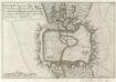
Haguenaw liegt im Untern Elsass ahn dem flüslein Moteren.
1 : 200000 Mollova mapová sbírka Person, Nikolaus Person, Nicolas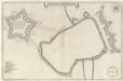
Gründtriß der Statt Hagenaw
1 : 7000 Mollova mapová sbírka Merian, Matthaeus Merian, Matthäus
Meßtischblatt 3583 : Saareinsberg, 1914
1 : 250000 Saareinsberg. - Aufn. 1883, hrsg. 1885, Auflagendr. 1914. - 1:25000. - [Berlin]: Königl. Preuss. Landesaufnahme, 1914. - 1 Kt.
Meßtischblatt 3584 : Niederbronn, 1885
1 : 250000 Niederbronn. - Aufn. 1883. - 1:25000. - [Berlin]: Reichsamt für Landesaufnahme, 1885. - 1 Kt.
Meßtischblatt 3585 : Wörth (An der Sauer), 1885
1 : 250000 Wörth (An der Sauer). - Aufn. 1883. - 1:25000. - [Berlin]: Reichsamt für Landesaufnahme, 1885. - 1 Kt.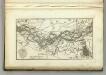
Map of the Course fo the Rhine, in the Environs of Strasbourg.
1 : 47000 Melish, John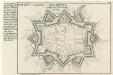
Pfalzburg :
Mollova mapová sbírka Bodenehr, Gabriel Bodenehr, Gabriel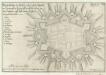
Phalsbourg oder Pfaltzburg :
Mollova mapová sbírka Person, Nikolaus Person, Nicolas
Meßtischblatt 3606 : Pfalzburg, 1884
1 : 250000 Pfalzburg. - Aufn. 1882. - 1:25000. - [Berlin]: Reichsamt für Landesaufnahme, 1884. - 1 Kt.
Blatt 13. Leutesheim, uit: Topographische Karte des Rheinstromes und seiner beiderseitigen Ufer von Hueningen bis Lauterburg oder längs der Französich-Badischen Gränze, ... / ... reducirt und gezeichnet ... im Bureau der Grossherzoglich Badischen Rheingränz-Berichtigungs Commission
1 : 20000 titelvariant: Rheingränz-Carte; Annotatie: Voor aanwezige bladen zie overzichtsblad Grossherzogliche Badische Rheingränz-Berichtigungs Commission. Bureau Freiburg im Breisgau : im Herder'schen Künst-Institut