Maps of Saverne

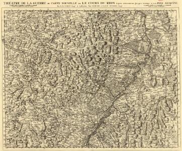
Théatre de la Guerre ou Carte Nouvelle De le Cours du Rhin depuis Strasbourg jusqu'a Worms et Les Pays Adjacens
1 : 250000 Mollova mapová sbírka Delisle, Guillaume Ottens, Josua
Cursus Rheni à Basilea usque ad Bonnam III. Sect.
1 : 260000 Mollova mapová sbírka Delisle, Guillaume Homann, Johann Baptista - dědici
Neue General Kriegs Karte des Rheinstrohms
1 : 2700000 hrsg. von Johann Walch In Augsburg : im Willischen Kunstverlag
Neue general Kriegs Karte des Rheinstrohms
1 : 270000 Alsasko (Francie) Walch, Johann Iohann Walch im Willischen Kunstverlag
12) VI.N.E. ''Mannheim'', uit: Carte géologique de France
1 : 500000 Annotatie: Voor aanwezige bladen zie bladoverzicht [S.l : s.n.]
Charte der Laender am Rhein von Strasburg bis Mannheim
Mannheim (Německo) Mannert, Conrad Adam Gottlieb Schneider u. Weigels
Charte von dem königlich Bayerschen Kreise des Rhein
1 : 360000 Bavorsko (Německo) Blume, J. A. Pladt

Charte der Lænder am Rhein von Strasburg bis Mannheim
1 Karte : Kupferdruck ; 47 x 65 cm Mannert in der kays: priv. Kunsthandlung Adam Gottlieb Schneider u: Weigels
Le Cours du Rhin depuis Strasbourg jusqu'a Worm et les Pays Adjacens
1 : 240000 Mollova mapová sbírka Delisle, Guillaume Liébaux L'Isle, Guillaume de
Cursus Rheni a Basilea usque ad Bonnam, III. sect. exhibitus
1 : 258000 Alsasko (Francie) Delisle, Guillaume per Homann. Heredes
Cursus Rheni a Basilea usque ad Bonnam, III. sect. exhibitus
1 : 258000 Alsasko (Francie) Delisle, Guillaume per Homann. Heredes
Cursus Rheni infra Argentoratum usq; ad Wormatiam, cum adjacentibus Regionibus
1 : 2900000 Mollova mapová sbírka Seutter, Matthäus Seutter, Matthäus
Per Inclyti Circuli Suevici Supremorum Ordinum :
1 : 160000 Mollova mapová sbírka Pfeffel, Johann Andreas Homann, Johann Baptista - dědici
Per Inclyti Circuli Suevici Supremorum Ordinum :
1 : 160000 Mollova mapová sbírka Pfeffel, Johann Andreas Pfeffel, Johann Andreas I.
Exactissima Tabula Electoratuum Moguntini, Trevirensis et Palatini Episcopatuum Spirensis, et Wormatiensis Comitatuum Sarbruck, Ottweiler Bitsch Sarwerden Falckenstein, Leiningen, Veldentz et Super et Inferior Sponheim.
1 : 240000 Mollova mapová sbírka Person, Nikolaus Person, Nicolas
Generalkarte von Zentraleuropa

Landgraviatus Alsatiæ inferioris novissima tabula
1 Karte : Kupferdruck ; 45 x 55 cm Visscher; Schenk nunc apud Petrum Schenk iunior
Die Grafschaft Hanau-Lichtenberg mit dem Departement Nieder-Elsas
1 : 180000 Müller, Johann Jakob
Neueste Karte und Richtige Vorstellung Aller Städte, Vestungen, Schlösser und remarquablen Ort, welche die Kron Frankreich zwischen dem Rhein, Saar, Mosel und im Elsaß wirklich besitzet
Mollova mapová sbírka Pfann, Wilhelm Ziegerkunst, Johann
Neueste Karte und Richtige Vorstellung Aller Städte, Vestungen, Schlösser und remarquablen Ort, welche die Kron Frankreich zwischen dem Rhein, Saar, Mosel und im Elsaß wirklich besitzet
Mollova mapová sbírka Pfann, Wilhelm
L'Alsace Divisée En Ses Principales Parties.
1 : 250000 Mollova mapová sbírka Jaillot, Alexis-Hubert Jaillot, Alexis Hubert
Charte des Baierschen [sic] Rheinkreises
1 : 629000 Bavorsko (Německo) Martin Gleditsch
Carte Particuliere Des Pays Qui Sont Situéz Entre Le Rhein, La Saare, la Moselle, Et La Basse Alsace [...] [Karte], in: Atlas nouveau, contenant toutes les parties du monde [...], Bd. 1, S. 244.
1 Karte aus Atlas Sanson, Nicolas Jaillot, Alexis Hubert und Mortier, Pieter
Le Theatre de Bellone :
Mollova mapová sbírka Schenk, Pieter Braakman, Adriaan
Landgraviatus Alsatiae Inferioris Novissima Tabula
1 : 280000 Mollova mapová sbírka Visscher, Nicolaes Jansz. Schenk, Peter II
Landgraviatus Alsatiae Inferioris novissima tabula, in qua simul Marchionatus Badensis, Ortenavia caeteraque tam Lotharingica quam alia confinia / accuratissimè describuntur per Nicolaum Visscher
1 : 300000 Annotatie: Cum privilegio Ordinum Hollandiæ et Westfrisiæ; Origineel is Blad 113 in atlas factice; Annotatie geografische gegevens: Schaalstokken: Milliaria Germanica communia, en: Milliaria Gallica communia Nicolaes Jansz. Visscher jr. 1649-1702 [Amsterdam : Nicolaus Visscher]
Carte particulìere des pays quì sont sítuéz entre la Rhein, la Saare, la Mosselle et la basse Alsace, contenant partìe du Palatinat, des Electorats de Mayence de Treves des Eveschés de Spìres et de Wormes avec les Duchés de Deuxponts et des Sìmmeren.
from Atlas françois : contenant les cartes geographiques dans lesquelles sont tres exactement remarquez les empires, monarchies, royaumes et estats de l'Europe, de l'Asie, de l'Afrique et l'Amérique : avec les tables et cartes particulieres de France, de Flandre, d'Allemagne, d'Espagne et d'Italie / par ... Hubert Iaillot, geographe ordinaire ...
Département du Bas Rhin
1 Karte : Kupferdruck ; 40 x 35 cm Capitaine s.n.