Maps of Erzgebirge

S. R. Imp. Circuli Franconici Geographica Delineatio Francken-Land mit Seinen Gräntzen
Mollova mapová sbírka Endter, Wolfgang Moritz Endter, Wolfgang Moritz
Militair Karte von Süd-Deutschland in 20 Sectionen
1 : 400000 3. Section Coulon, Alois von A. von Coulon
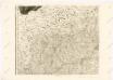
Terra Advocatorvm vulgo Voightland
1 : 290000 Vogtland (Německo) Örnehufvud, Olof Hansson Blaeu, Joan J. Blaeu
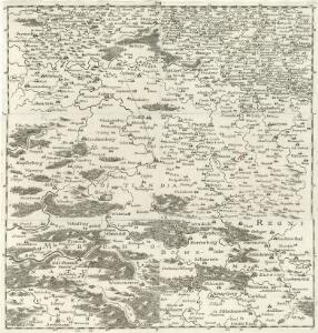
Carte topographique d'Allemagne contenant une partie du royaume de Boheme, une partie de la Saxe
1 Karte : Kupferdruck ; 46 x 61 cm Jaeger; Hauer se vend chez I. W. A. Iaeger
TERRA ADVOCATORVM | Vulgo | VOIGHTLAND
Descripta ab Olao Ioannis Gotho | S.R.M. Sueciæ Geographo. Amstelædami | J. Blaeu excudebat.

Terra Advocatorvm Vulgo Voightland
1 : 290000 Mollova mapová sbírka Örnehufvud, Olof Hansson Blaeu, Joan I.
Mappa geographica regni Bohemiae in duodecim circuloc divisae ... Sectio. VI.

Delineatio geographica specialis territorii celsissimorum S. R. I. comitum Ruthenorum de Plauia utriusque linea senioris et iunioris partem Vogtlandiae
1 : 150000 Greiz (Německo) Schulz, Johann Gottlieb Lotter, Georg F. Tob. Conrado Lotter
Delineatio geographica specialis territorii celsissimorum S.R.I. comitum Ruthenorum de Plauia utriusque linea senioris et iunioris partem Vogtlandiae
1 : 150000 Greiz (Německo) Schulz, Johann Gottlieb Lotter, Georg F. Tob. Conrado Lotter
Delineatio Geographica Territorii Celsissimorum S.R.I. Comitum Ruthenorum de Plauen utriusque Lineae Senioris nempe ac Iunioris partem Vogtlandiae olim ac hodie sic dictae constituentis
1 : 140000 Mollova mapová sbírka Homann, Johann Baptist Homann, Johann Baptista
Delineatio geographica territorii celsissimorum S.R.I. comitum Ruthenorum de Plauen utriusque lineae senioris nempe ac iunioris, partem Vogtlandiae, olim ac hodie sic dictae constituensis
1 : 140000 Plauen (Německo) impensis Homannianorum Heredum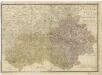
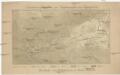
Elbogner dan Saatzer Kreis und Egerische = Gebiet

Zu den Operationen der Generale Syburg, Schenkendorf und Linden gegen die Reichsarmee, vom 15ten Februar bis zum 5ten April 1761

[Karlovarsko]
Karlovy Vary-oblast (Česko)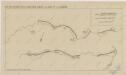
Sbírka map a diagramů použitých na mírových konferencích v Paříži v letech 1919 - 1920
Orientirungskartchen zur Hydrographie des Egergebietes
Krušné hory (Česko a Německo)
Reußische Fürstentümer 1848, Reuß ältere Linie, Reuß jüngere Linie
Reuß Älterer Linie, Reuß Jüngerer Linie Kunz, Andreas ; Moeschl, Joachim Robert
Reußische Fürstentümer 1824, Reuß ältere Linie, Reuß jüngere Linie
Reuß Älterer Linie, Reuß Jüngerer Linie Kunz, Andreas ; Moeschl, Joachim Robert
Charte vom Elbogner Kreise ...

142. Plauen (bijgeschreven: Löbenstein), uit: Topographische Uebersichtskarte des Deutschen Reiches / herausgegeben v. d. Kartogr. Abt. d. Königl. Preuß. Landesaufnahme
1 : 200000 titelvariant: Topogr. Übersichtskarte des Deutschen Reiches; Annotatie: Titel boven bladen ook: Topogr. Übersichtskarte des Deutschen Reiches; Annotatie geografische gegevens: Op elk blad twee maatstokken: 10 Kilometer = 5,5 cm; 1 geogr. Meile = 3,6 cm; Legenda onder op elk blad Königlich Preußische Landesaufnahme. Kartographische Abtheilung [S.l : Königlich Preußische Landesaufnahme, Kartographische Abtheilung]
Carte von Ertzgebürgischen Creysse in Churfurstenthum Sachssen
1 : 170000 Mollova mapová sbírka Schenk, Pieter Schenk, Peter I
Elbogner dan Saatzer Kreis und Egerische-Gebiet
1 : 240000 Loket-oblast (Sokolov, Česko) Berndt, Johann Christoph Peter franza [sic]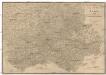
Elbogner dan Saatzer Kreis und Egerische-Gebiet
1 : 240000 Loket-oblast (Sokolov, Česko) Berndt, Johann Christoph Peter franza [sic]
Elbogner dan Saatzer Kreis und Egerische Gebiet
1 : 240000 Loket-oblast (Sokolov, Česko) Berndt, Johann Christoph Peter Franza
Elbogner dan Saatzer Kreis und Egerische Gebiet
1 : 240000 Loket-oblast (Sokolov, Česko) Berndt, Johann Christoph Peter Franza
Elbogner dan Saatzer Kreis und Egerische Gebiet
1 : 240000 Loket-oblast (Sokolov, Česko) Berndt, Johann Christoph Peter Franza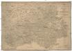
Elbogner dan Saatzer Kreis und Egerische Gebiet
1 : 240000 Loket-oblast (Sokolov, Česko)