Maps of Weißenburg-Gunzenhausen

Weitere Fortsetzung des heurigen Kriegs Theatri
Mollova mapová sbírka Lidl, Johann Jakob Lidl, Johann Jacob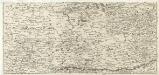
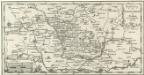
S. R. Imp. Circuli Franconici Geographica Delineatio Francken-Land mit Seinen Gräntzen
Mollova mapová sbírka Endter, Wolfgang Moritz Endter, Wolfgang Moritz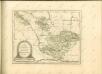
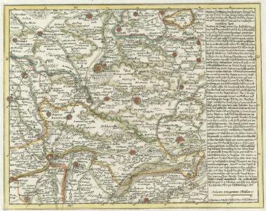
Vorstellung der Teuffels-Mauer in Nordgau und anliegenden Gegenden
1 : 340000 Mollova mapová sbírka
172. Nördlingen, uit: Topographische Uebersichtskarte des Deutschen Reiches / herausgegeben v. d. Kartogr. Abt. d. Königl. Preuß. Landesaufnahme
1 : 200000 titelvariant: Topogr. Übersichtskarte des Deutschen Reiches; Annotatie: Titel boven bladen ook: Topogr. Übersichtskarte des Deutschen Reiches; Annotatie geografische gegevens: Op elk blad twee maatstokken: 10 Kilometer = 5,5 cm; 1 geogr. Meile = 3,6 cm; Legenda onder op elk blad Königlich Preußische Landesaufnahme. Kartographische Abtheilung [S.l : Königlich Preußische Landesaufnahme, Kartographische Abtheilung]
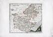
Nova comitatus Pappenheimensis tabula, cum finitimis diversorum imperii statuum locis et tractibus, nec non dynastia Bellenberg in Suevia sita
1 : 90000 Švábsko (Německo) impensis Homannianorum Heredum
Bairische Landtafeln XXIIII. Darinnē das hochlöblich Furstenthumb Obern unnd Nidern Bayrn sambt der Obern Pflaz Erz unnd Stifft Salzburg Eichstet unnd andern mehrern anstossenden Herschafftē]
1 : 145000 Mollova mapová sbírka Apian, Philipp Amman, Jost Apian, Petrus
Nova Comitatus Pappenheimensis Tabula
1 : 80000 Mollova mapová sbírka Homann, Johann Baptist Homann, Johann Baptista - dědici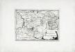
Die Grafschaft Pappenheim
1 Karte : Kupferdruck ; 19 x 27 cm Reilly F. J. J. von Reilly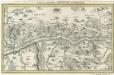
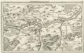
Gegend zwischen Neuburg und Donauwerth.
1 : 140000 Mollova mapová sbírka Bodenehr, Gabriel Bodenehr, Gabriel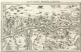
Gegend zwischen Neuburg und Donauwerth
Mollova mapová sbírka Bodenehr, Gabriel Bodenehr, Gabriel
Neuburg an der Donau mit der Gegend auf 2 Stund.
1 : 170000 Mollova mapová sbírka Bodenehr, Gabriel Bodenehr, Gabriel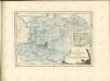
Ingolstatt mit der Gegend
Mollova mapová sbírka Riegel, Christoph Bodenehr, Gabriel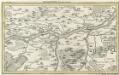
Ingolstatt mit der Gegend.
Mollova mapová sbírka Bodenehr, Gabriel Bodenehr, Gabriel
A plan of the famous victory at Bleinem obtained by His Grace the Duke of Malborough over the Elector of Bavaria and the Marechals Tallard and Marcin, the 13th August, 1704 S.N
1 : 20000 J. van Vianen fecit [Amsterdam] : Reynerus Leers excudit
Plan of the glorious Battle of Hochstet
Plan of the glorious Battle of Hochstet [or Blenheim]. ... For Tindal's Continuation of Rapin's History of England. [London]
Accurater Prospect u. Grundris der Gegend der Kayserl. Freyen Reichs Stadt Weissenburg am Nordgau
1 : 20000 Mollova mapová sbírka Homann, Johann Baptist Homann, Johann Baptista
Unter allen Schlachten dieses Seculi hat die Höchste Stadt die Schlacht bey Höchstädt geschehen den 13. Aug. 1704

Oettingscher Plan, der blutig dencontre so d. 19. Aug. 1726 zwischer vom fürstl. u. gr. ottingl. und Nördlingl. der gefallen
Mollova mapová sbírka
[Plan von Sulzburg]
1 Plan : Kupferdruck ; 14 x 18 cm Merian Merian
La Battaille de Hoechstedt
1 : 50000 Mollova mapová sbírka Husson, Pieter Husson, Pierre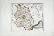
Die Grafschaft Oetingen
1 Karte : Kupferdruck ; 23 x 27 cm Reilly F. J. J. von Reilly
Ingolstad 129, uit: Special-Karte von Mittel-Europa / nach amtlichen Quellen bearbeitet von W. Liebenow
1 : 300000 titelvariant: W. Liebenow's Mittel-Europa; Annotatie: Titel boven de bladen: W. Liebenow's Mittel-Europa Johannes Wilhelm Liebenow 1822-1897 Frankfurt a. M. : Ludwig Ravenstein
Sacri Romani imperii circuli et electoratus Bavariae tabula, 3
4 Blätter : s.n.
[Fol. I]
1 Karte : 43 x 55 cm Königliche Akademie der Wissenschaften
Das Herzogthum Ober und Nieder Baiern, 1
1 Karte : 43 x 55 cm Lotter
Souabe Septentrionale.
1 : 240000 L'Isle, Guillaume de, 1675-1726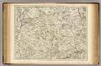
Souabe Septentrionale.
1 : 240000 L'Isle, Guillaume de, 1675-1726